Long before we embarked on our [potentially] year-long adventure, Jenn had stumbled across a company called Oxalis Adventure Tours that does caving expeditions in Vietnam’s Phong Nha-Ke Bang National Park. Oxalis has an exclusive license to operate in a number of caves in the area and runs small group sizes, ensuring a more private and personal experience.
Phong Nha-Ke Bang National Park protects one of the largest and oldest limestone karst regions in the world, containing over 300 caves and grottos, including the largest cave in the world, Son Doong, which has a passage measuring 5 kilometers long by 200 meters tall. The park was declared a UNESCO world heritage site in 2003, thanks to its unique geology, enormous expanse, and endemic species diversity within its caves and landscapes. Our exploration was confined to the Tu Lan Cave system, a collection of 10 caves around 70 kilometers northwest of Phong Nha, near the small village Tan Hoa. These caves have only been fully explored relatively recently, starting in 1992 but with new areas being found as recently as 2012.
We arrived in Phong Nha by bus, which started out poorly when we were crammed into a stifling minibus and driven in circles around Huế for 30-40 minutes, at speeds any respectable tortoise would have easily outpaced. We were dropped off a mere kilometer or two from where we started, and boarded a large bus that was also inclined to operate at a slug’s pace, stopping frequently to pick up packages, shout at people along the road, and occasionally take on a new passenger. Once we finally achieved a faster-than-walking speed, Jenn sniffed, “do you smell smoke?” The driver, not wanting to get damp in the rain that started to fall, decided it was best to indulge his nicotine habit directly into the recirculated air of our sealed bus. The last straw came when we arrived in Phong Nha and were instructed to get off the bus to wait for our hotel pickup. After a few minutes of standing around, the bus driver started gesturing for us to get back on the bus again, which seemed odd, so I hesitantly boarded. Jenn clearly wasn’t fast enough for them, as the driver grabbed her bag’s shoulder harness and yanked, while the co-driver shoved her from behind. Enough was enough, so we pushed our way off the bus and stalked up the street in the rain, determined to find our own way, only to discover that the hotel was a mere 100 meters or so from the bus station.
Upon arriving (finally, and in one piece), the hotel announced that we were given a beautiful mountain view, which we unsuccessfully attempted to admire through the pitch blackness and falling rain. In the morning, however, we were in fact treated to the morning light illuminating a spectacular limestone peak immediately across the road. A quick breakfast and we boarded our transfer to the caves, enjoying a winding journey along the Ho Chi Minh highway, passing verdant mountains, flooded rice fields, and a landscape that was positively bristling with jagged limestone formations.


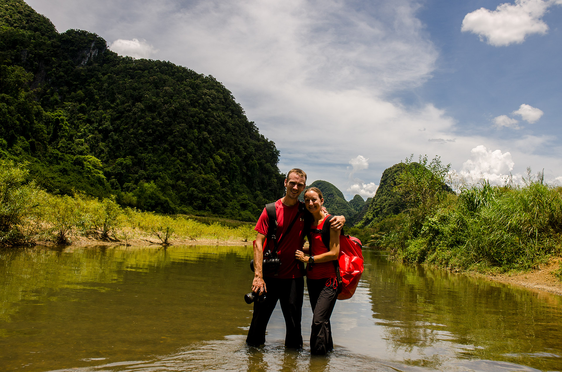
Our group was small, only 5 people in total, with two easy-going Americans from Utah, and an extremely quiet gentleman from Korea. Our two Vietnamese guides, Lam and Binh, were friendly and chatty, quick to laugh or joke, and proved to be an endless source of entertainment throughout the trip. We all set off through the valley between the dramatic stone outcroppings, passing “cow city” along the way – a group of buildings to provide shelter for the roughly 700 Tan Hoa villagers’ livestock, built at the base of the limestone cliffs. Locals began building these shelters near the steep rocks after a devastating flood in 2010, in order to more quickly evacuate their cattle to higher ground when water levels begin to rise.

The walk along the flat valley floor went quickly, with the grassy expanse rising and falling gently, bisected by the gentle current of the Rao Nan River. We soon found ourselves scrambling up some boulders while cool, damp air wafted down from above. Reaching the top, we stared down into the gaping entrance of Rat Cave. I’m not entirely sure what I expected – maybe more like a person-sized entrance to a larger expanse beyond – but the yawning maw of the cave mouth dwarfed us as we passed underneath.


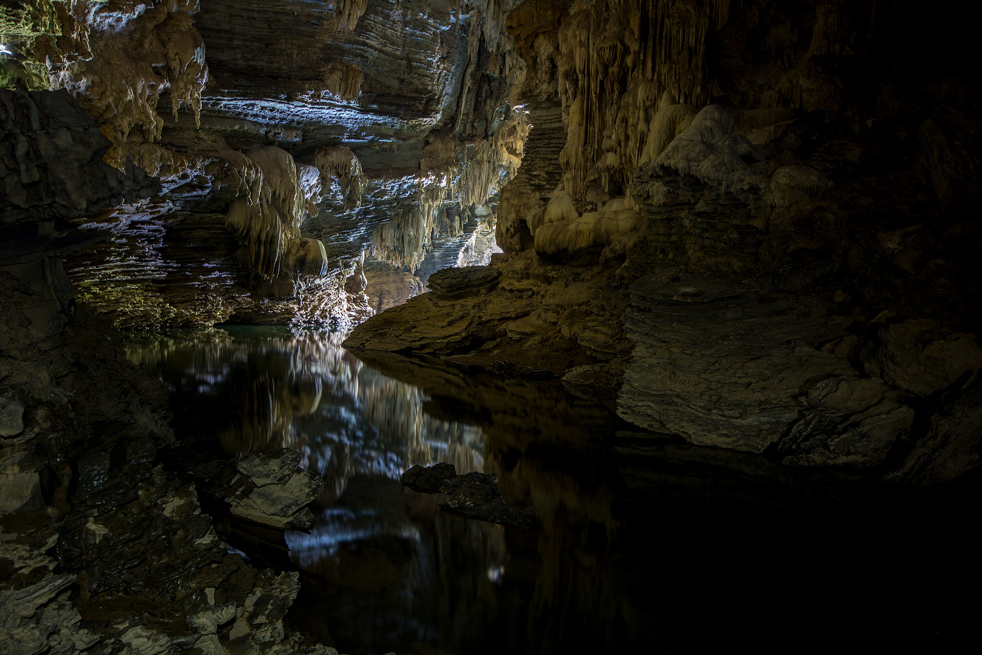
All of the caves in this region were carved by flowing water, working its way into cracks in the limestone and patiently wearing away tunnels through the mountains over millions of years. This means that the “dry” caves, without any flowing water, tend to be the oldest (roughly 5 million years old) and at the highest elevations, with their formations blunted and worn from years of wind and dripping calcium carbonate-rich water. Rat Cave was such a cave, one of only two we would visit that required no swimming. As we wandered through the 300-meter-long passage, we wove amongst beautifully patterned stalactites and stalagmites – ribbed columns jutting out of the floor, lumpy stone piles resembling softened ice cream, and formations that dangled from the ceiling like melting icicles. Lam asked if anyone was afraid of spiders, before helpfully pointing out a truly enormous, hand-sized cave spider, whose eyes glowed in the reflected light of our headlamps. We explored a side-passage to discover cave crickets, roughly 3 times the size of a normal cricket, who seemed to leap 5–6’ with ease.


After we emerged, blinking, back into the sunlight, we hiked a short distance for a picnic lunch by a small stream that ran through La Ken Valley. Our do-it-yourself banh mi – a Vietnamese sandwich with any number of ingredients tucked into a baguette – were delicious, and I was introduced to one of my guilty pleasures for the rest of the trip, the Choco Pie. Choco Pies consist of a horribly artificial marshmallow filling, soft, preservative-laden cookies, and a chocolate coating that is hardly worthy of the name. It all adds up to a sickeningly-sweet dessert that I was immediately hooked on, and am happy that they don’t seem to be sold outside Vietnam, lest I make an entire diet out of them.
After lunch we headed uphill, climbing 150 meters to the top of Lom Com Mountain, which presumably means ‘Place of Red Welts’ after our experience with the voracious mosquitos there. Fleeing our tiny, winged attackers, we ascended Mango Mountain before picking our way back down the rocks to arrive in Tu Lan Valley, at a campsite beside a small waterfall. The cool, blue waters were perfect for washing away all the sweat and dirt of the day, and we happily discovered a nook behind the waterfall where not even these incredibly persistent mosquitos could penetrate. Plus, frankly, if there’s a better way to end a hike than leaping off rocks into the base of a waterfall, I don’t think I know of it.


After dinner, Lam and Binh broke out a deck of playing cards, where they proceeded to teach us – and then school us – in the intricacies of two of their local games, tinlen and binh. Tinlen seems to be a much more complicated version of the American game of “asshole (pig),” while binh was a unique game involving organizing and playing combinations of traditional poker hands. In particular, Binh excelled at his namesake game, organizing his cards into ideal hands at a pace that indicated some kind of innate genius for numbers. He often had his entire hand planned before Jenn and I had a chance to even take inventory. Jenn showed a talent for the game as well, while I seemed to struggle with getting through all of the possibilities in a timely manner, either leaving the other players impatiently waiting, or making a hurried and incomplete decision.
The next morning, we headed into Ken Cave, our first “wet” cave. Ken Cave has a river snaking through it, so we were going to have to swim 200 meters before finding a place to explore on foot. We strapped on our dry bags, tightened our helmets and jumped into the beautiful turquoise water. After the initial odd sensation of swimming with a hiking pack, clothes, and boots on, it was pleasant to be floating in the cool waters of the cave. The bats enjoyed our intrusion as well, since our headlamps attracted swarms of bugs, ensuring an easy meal while they swooped again and again in front of our lights. As a wet cave, Ken Cave was quite a bit younger than Rat Cave (wet caves in this area average around 3 million years old), and thus was very different – full of many more delicate, jagged or sharp formations than the first cavern, and still undergoing active erosion. Here, I experimented for the first time with “light painting” – setting up my camera on a tripod and triggering the shutter, then playing my flashlight beam across the cavern to illuminate the formations.


After lunch, we set off in our sodden clothes and eventually squished our way through the forest to a vibrant green river flowing out of a pitch black hole in the side of the mountain. Tu Lan Cave has both a wet and a dry entrance, allowing us to swim in and then trek out the other side. Another younger cave, Tu Lan provided some of the most interesting and varied rock formations we saw during the trip. Sculpted rock terraces filled one room; nearby, stone waterfalls poured out of the ceiling and petrified broccoli florets erupted from the floor.


After a short, 1.5-km walk, we reached our next cave, Kim Cave, which also had a wet and dry entrance. After a longer, upstream swim – around 500 meters – we pulled ourselves out of the water to discover we had arrived at a striking little water cascade, its small roar echoing in the empty cavern. While the formations in Kim Cave seemed to be more simple than the others, the clear, green waters cascading down the rocks were stunning.


After a peaceful night in the To Mo Valley, and getting whipped in many more hands of binh and tinlen, we set off on our third and final day of caving. We had a short 100-meter swim into Hung Ton Cave, where Lam showed us a new type of rock formation – ‘cave pearls.’ These small spheres are formed as water drips from the cave’s ceiling (over the course of hundreds of years), eventually drying and encasing grains of sand in a shell of calcite crystals. Lam informed us that they look like stones, but are actually quite fragile and can crumble into dust if exposed to air/sunlight outside the cave. To exit Hung Ton, a 15-meter (50-foot) ladder allows access to the elevated dry passage – which doesn’t sound like much until you’re standing on top of it looking down!


Finally, after a trek thru the jungles of Hung Ton Valley, we squeezed our way into Secret Cave, one of the least explored caves in the system. Secret Cave is accessed through an incredibly tight passage that seemed to be nothing more than a hole in the side of the hill, and doesn’t feel like much more than that while you’re worming your way inside. Explorers have attempted to investigate a number of passages inside the cave, but most of the crevices haven’t been large enough to pass through, meaning there are likely other passages inside that are still undiscovered.


As we exited the smaller Secret Cave, we discovered that we were overlooking the same river we crossed on the first day, leading us back to the Oxalis basecamp. Despite the permanently wet clothes/boots, a persistent smell of swamp water, and mosquito bites dotting every inch of exposed skin, we were both disappointed to head back. Our caving adventure in central Vietnam was definitely one of the best things we’ve done in Asia!


Total distance: 13.2 miles (jungle trekking = 10.1 miles, caving = 2.5 miles, swimming = 0.6 miles)
Elevation gain: 1,969 feet


Light painting was really great! The s-s-s-s-spider…argh!! Why did you specify women in the picture of the two graves? Also, what on earth was in your packs? Jenn’s pack looks like it weighed more than she does! Great pictures. Countryside is spectacular.
Mom
The women’s tombs had fences around them, while the men’s did not. Packs were full of camera gear in dry boxes, and anything else we needed for the day’s trekking.
Great pics! Esp the beautiful spider pic!!! <3 <3 <3