Nestled snugly amongst the thick evergreen forests of the verdant Matter Valley (Mattertal) sits one of Switzerland’s most beautiful treasures. Named for the prominent peak that stands like a sentry over the remote, alpine village, Zermatt is a veritable haven for skiers, hikers, and outdoor adventurers alike. Under the protective shadow of the Matterhorn’s snow-capped slopes, rustic chalets and Valais blacknose sheep pepper the valley floor. Only three main streets span the hamlet, and for as long as anyone can remember, the town has been ‘car-free.’ The only vehicles permitted along Zermatt’s pristine avenues are miniature, electric-powered taxis and small service vehicles (also electric). In an effort to preserve air quality and, in turn, residents’ flawless view of the country’s revered Matterhorn, gas-powered engines are strictly prohibited, and cars must be parked in a lot some five kilometers (three miles) outside the town limits. Because of this thoughtful restriction, most visitors arrive in Zermatt via the Matternhorn Gotthard Bahn, a gorgeous little train running from the nearby mountain towns of Brig and Visp. As our train pulled away from the platform in Brig, warm sunshine and panoramic, alpine views enveloped us as we snaked along the turquoise waters of the Vispa River. When we arrived in Zermatt an hour later, it was as if we were suddenly teleported back in time to a more peaceful world – where crowded streets were traded for quaint passageways, and the sounds of car engines and horns were magically replaced by bleating ewes and whistling songbirds. And that view of the Matterhorn? It was as close to perfection as I could imagine.


HÖRNLIWEG
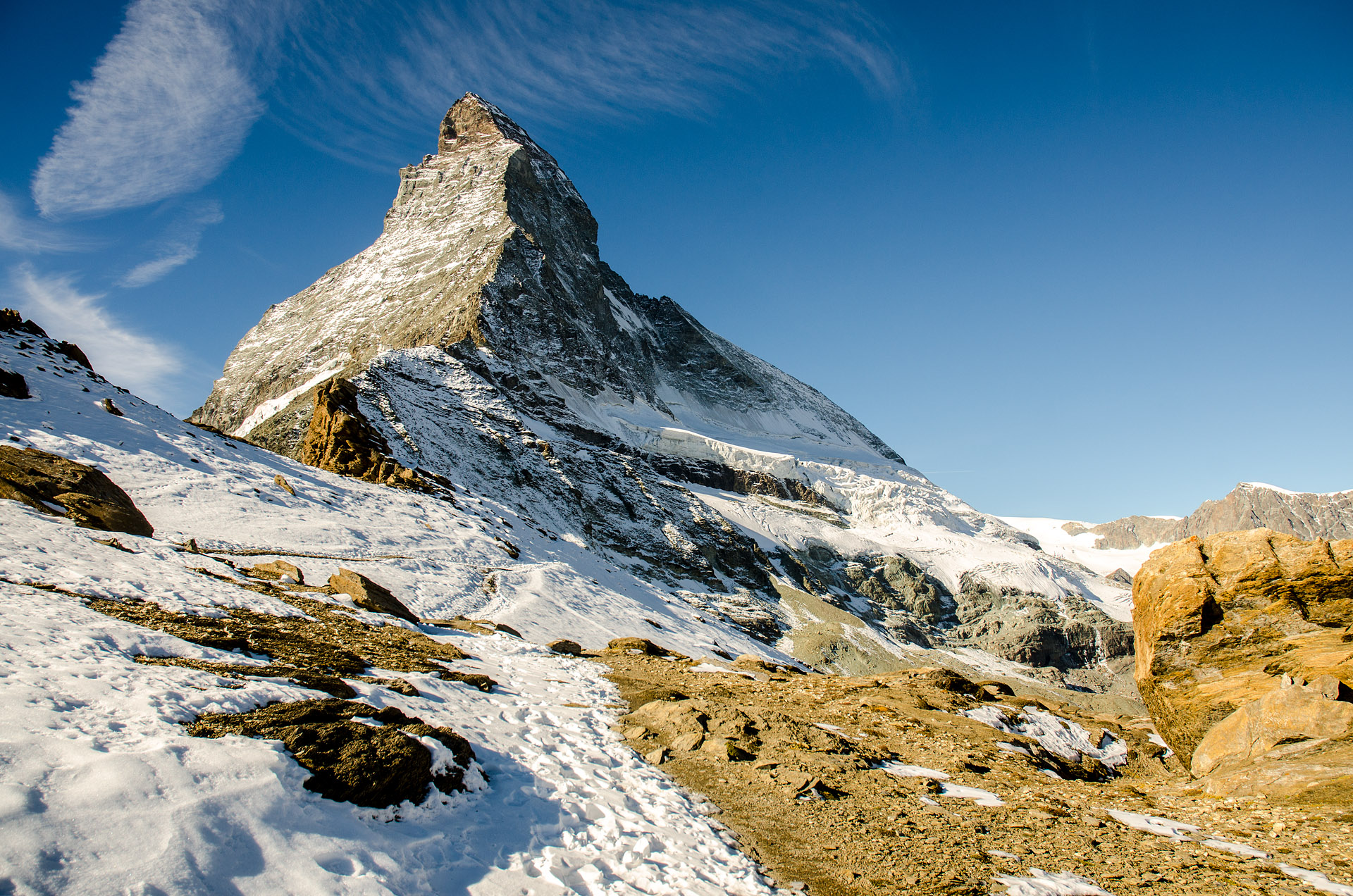
The morning of our first full day in Zermatt, we awoke to find a crystal-clear view of the Matterhorn’s summit greeting us through the French doors that lead out to our garden terrace. With not even a wisp of a cloud in the sky, we decided to dedicate our first day of hiking to the iconic trail that winds along the Matterhorn’s northeastern slope to the basecamp at Hörnlihütte. Similar to our experience in the Dolomites, we ended up resigning ourselves to the [pricey] lifts to get up out of the valley, as hiking up through the forest would tack on 3–5 hours in one direction – an entire day of hiking in itself if followed round-trip, let alone with autumn’s attenuated daylight hours.
We headed out into the crisp morning air, seemingly now the end of our nine-month, perpetual summer, and hopped on the Matterhorn Express to Schwarzsee. As the gondola climbed out of the valley, we were awestruck by the views of the incredible summits surrounding us. The glaciated peaks were aglow in the intense sunshine, soaring over the blanket of fluffy fog that had cunningly crept into the Matter Valley. Under the pervasive peak of the Matterhorn, the trail passed by the sapphire Schwarzsee Lake before climbing alongside an expansive glacial valley. The trail eventually twisted to the more northern edge of the ridge, and the persistent shade gave rise to a slick, snow-covered track. With fixed ropes to assist as the trail ascended more steeply over slippery sections of snow and rock, we carefully made our way up. With each step we took, the view just seemed to get better and better, and we struggled to put down the cameras (embarrassingly, by the day’s end, I may or may not have snapped 466 photographs of the Matterhorn and its snow-capped neighbors. I swear this was an atypically inflated number of shutter clicks).
The trail eventually turned back toward the east, and we made one last ascent up a sun-drenched, rocky ridge, now finally free of the slick snow cover. Balanced at the edge of the Hörnligrat, the Matterhorn’s sheer, northeastern ridge, Hörnlihütte base camp overlooked the steep glacial valley below. Here, the fingerlike projections of the Furgg, Theodul, Triftji, Breithorn, and Gorner Glaciers poured into a craggy, russet basin, peppered with small glacial pools. At 3,260 meters (10,696 feet), Hörnlihütte’s expansive sundeck offered the perfect lunch spot, with unsurpassed views of the 4,000-meter massifs of the Pennine Alps in the distance, as well as the bowed summit of the 4,478-meter (14,692-foot) Matterhorn looming overhead.


Total distance: 5.7 miles
Elevation gain: 2,323 feet


Note: Some of the snowy sections of trail are quite exposed, and while there are fixed ropes in spots, crampons might be a reasonable consideration. Our hiking boots proved to be okay, but we were descending the slick areas quite slowly. While there weren’t a lot of other hikers on the trail, about half had on crampons, and I’m guessing it would have given a feeling of extra security in addition to (obvious) better traction.
Glacier Paradise
Because we had purchased full-price lift tickets for the day, we decided put our passes to their full use and make a quick trip up to Glacier Paradise after our incredible hike to Matterhorn base camp. Perched atop the summit of Klein Matterhorn (‘Little Matterhorn’) at 3,883 meters (12,740 feet), Glacier Paradise is the highest cable car station in Europe. Not only are the views expectedly awesome, but the station serves as a base for some fantastic year-round skiing on the Theodul Glacier. Apparently, it’s a summer training paradise for international ski teams and, in fact, when we purchased our tickets that morning, a skier from the Swedish national team was heading up for some work on the slopes.
While skiing wasn’t on our agenda for the afternoon, we did enjoy the panoramic vistas from the Breithorn Viewpoint. As its name suggests, the lookout offered a stunning glimpse of neighboring Breithorn’s summit (13,661 feet; 4,164 meters), recognizable by its weighty crown of glistening, perennial snow. To the northwest, the frozen expanses of the Theodul and Furgg Glaciers blanketed the landscape. From here, we were able to look back at Hörnligrat, as well as the swath of terrain we’d hiked only hours earlier. We were also able to get a unique view of the surprisingly furrowed south face of the Matterhorn, soaring majestically above a spine of serrated peaks in the distance.


FIVE LAKES
For our second day of hiking, we opted for a trail that our host had suggested to us, as it was unexpectedly difficult to find a lot of route information online. With weather that was nearly as nice as the previous day, we set out for the ‘5-Seenweg’ (Five Lakes) trail. Akin to the previous day, we headed to the town center and hopped on the funicular to Sunnegga. From the top of the funicular station, we were again welcomed with a lovely view of the celebrated Matterhorn, though today only the crooked crest peeked out from a ribbon of cottony, cumulus clouds.
The Five Lakes trail rolled gradually along gentle hills, passing through sunlit alpine meadows and shaded coniferous forests. While it was only the beginning of October, the deciduous needles of the larch trees were already turning a dazzling shade of yellow, creating a smoldering canopy above our heads as we traversed the wooded hillside. As we walked, the trail’s five namesake lakes – Leisee, Mosjesee, Grünsee, Grindjisee, and Stellisee – popped one by one from the picturesque landscape. Small fish circled in the shallows of the translucent pools, and the Matterhorn’s reflection could be seen in the mirrored surfaces of three of the lakelets (Leisee, Grindjisee, and Stellisee). If pressed to pick a favorite lake, I’d probably choose Grindjisee, as it’s tucked off the trail a bit, offering not only some additional serenity but ostensibly the most photogenic perspective of the Matterhorn, its muted point framed by verdant pines and golden grasses.
Upon reaching the last lake, Stellisee, the trail forked in two directions – one leading up to Blauherd (and ultimately back down to Sunnegga), and one branching off toward Fluhalp, a summer-season lodge with panoramic views of Adlerhorn’s tapered summit and the undulating tongue of the Findel Glacier. We selected the latter, to try to extend the hike a bit before returning to Sunnegga, and also to check out some additional alpine scenery. When we arrived at Fluhalp, we were met with a rewarding vista of the crests of Adlerhorn, Strahlhorn, and Rimpfischhorn. We could also see what appeared to be the top of a glacial flow, although a short ridge hindered our view into what we thought was a glacial valley. Thus, we headed up the side of the ridge via some nicely-worn sheep tracks to try for a better vantage point. Indeed, upon reaching the top of the rise we were able to peer straight down onto the Findel Glacier – a totally worthwhile extension of the hike.
Although undeniably scenic, this was probably our least favorite hike of the lot. While it was nice to change up the typical summit scenery with some lakes and pine forests, there just wasn’t a lot of elevation gain, and it kind of lacked that wow factor. For anyone looking for an easy day hike in the area, though, this one may fit the bill.


Total distance: 8.8 miles
Elevation gain: 1,904 feet


HÖHBALMEN
Our final hike in Switzerland was up to what is evidently considered one of Zermatt’s most spectacular viewpoints, Höhbalmen. The hike was recommended to us earlier in the day by our paragliding pilot, Chris. Even though our paragliding adventure consumed half of a day, we managed to squeeze in just under half of the longer circuit Chris had suggested (we opted to just start late and shorten the route as the forecast predicted some iffy weather the following day). I have to say, we were both extremely glad that Chris mentioned Höhbalmen to us, as our search for hikes online didn’t turn up any results for this route (much to our surprise after seeing how spectacular the hike was).
The route to Höhbalmen began from the center of Zermatt village, a highpoint right from the get-go as we didn’t have to take another silly (and expensive) cable car/funicular/train to effectively embark on our hike. The first part of the trail climbed fairly steeply to Edelweiss, a hotel and restaurant perched prominently at the edge of the cliff face overlooking the quaint hamlet. From here, the trail split in two directions, each leading to either end of the loop trail. It was already mid-afternoon, and we knew we’d likely not have the time to complete the entire loop. Thus, after a bit of indecisiveness (we were using Chris’ hand-drawn, blue sticky note as our guide), we ultimately opted to head left toward Zmutt, as that was one of the landmarks on our trusty, cartoon map… and we at least knew it was in the direction of the Matterhorn.
The trail from Edelweiss to Höhbalmen climbed quite steeply, averaging around a 23% grade (~3,600 feet of gain over 3 miles). The dirt track wrapped around the flank of a scenic hillside, draped in golden grasses and providing an ever-present view of Zermatt’s charming chalets as well as the imposing summits that encircle the Matter Valley. The one peak we had yet to see along the trail, though, was the Matterhorn, and we began to wonder if the path would ever crest the sharp slope like we thought it would. Eventually, and quite suddenly, the track did finally level out atop the hillside, giving way to a gorgeous panorama of the Matterhorn and a number of other snow-capped crests of the Pennine Alps – Klein Matterhorn, Breithorn, Castor and Pollux, Liskamm, Monte Rosa (Switzerland’s highest peak), Adlerhorn, Strahlhorn, and Rimpfischhorn. It was just breathtaking and, while we didn’t have time to complete the entire loop before the sun fell below the horizon, we were extremely happy we were able to fit in this hike. Thanks, Chris – it was a stunner!


Total distance: 6.4 miles
Elevation gain: 3,581 feet


Suffice it to say, I loved Zermatt… like, really loved it. I expected it to be beautiful, but I guess it substantially surpassed any expectation I had. The visit definitely made me want to return Switzerland again, to spend significantly more time hiking in the Alps. Heck, I could even see myself living there, and I am not a cold-weather person (I know, I know… being a New Englander I should inherently love snow and winter and all that other crap, but I don’t). While the mercury topped out in the high 40s (8–9°C) while we were there (sans wind chill), the amazing views and laid-back atmosphere made you (almost) forget how chilly it was. Zermatt, we were completely enchanted by your scenery and charm, and we shall return!
Yet another random aside:
When we were in Tuscany with the family, we learned that my brother’s friends would be heading to Zermatt in December. Looking forward to some fresh powder for boarding and skiing, they requested a ritualistic snow dance while we were there. Aspiring for the maximum success, I figured there was no better place for the ritual than on the snow-covered slopes of the Matterhorn. Thus, on the morning of October 8th, I did a few twirls and made some convincing appeals to the Swiss snow gods. Apparently, I have some friggin’ effective skills, because a mere three days later, on the 11th of October, it snowed. I mean, it was quite a trivial dusting, but I shall still maintain that I made it snow. Here you go, Robby and Cassie – proof of flakes and many good vibes for a safe, snowy, and spectacular trip to Switzerland!


Amazing. Doesn’t look like you need a snow dance, though.