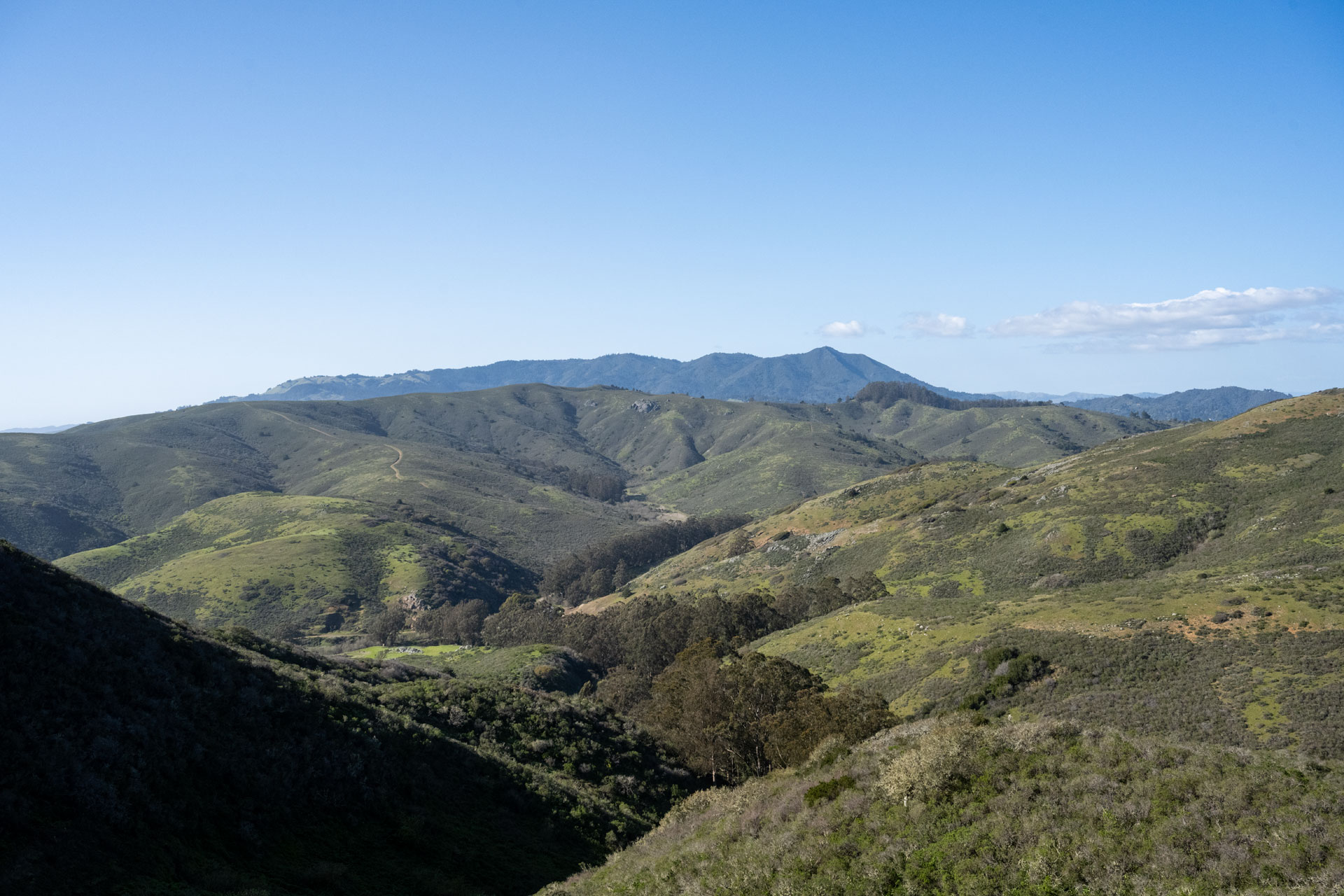
A stunning spot for any visitor to the Bay area, the Marin Headlands are a scenic stretch of coastal cliffs that sit just north of the Golden Gate Bridge. Here, you can enjoy blufftop trails, sandy beaches, historic batteries, towering redwoods, charming lighthouses, and views of San Francisco’s most iconic landmark.
The Marin Headlands are part of the 80,000-acre Golden Gate National Recreation Area (GGNRA), one of the world’s largest urban national parks. The amount of things to explore here is kind of overwhelming. There are 37 individual park sites, 19 distinct ecosystems inhabited by more than 2,400 unique plant and animal species, 1,200 historic structures, over 130 miles of trails, and dozens of camping sites, picnic areas, and beaches. GGNRA is also home to a few of San Francisco’s most famous attractions: Muir Woods, Alcatraz, and The Presidio of San Francisco.


This sprawling natural and cultural preserve is spread across three counties: Marin (north of the Golden Gate), San Francisco (south of the Golden Gate), and San Mateo (south of SF). With hundreds of natural and historic sites peppering such a huge area, you can’t begin to see it all in just a short stay. Consequently, we’re here to offer a few of our favorite spots to help get you started.
If nothing here speaks to you, check out a comprehensive inventory of things to do on the GGNRA website. There’s certainly no shortage of options within this diverse park. The preserve has got something for everyone; there are a number of dog-friendly trails and beaches; and it’s just plain gorgeous. A bonus for us was that, with our home base in Sonoma, a large chunk of the GGNRA – specifically, the Marin Headlands – was north of the Golden Gate. This meant we didn’t have to cross the bridge at $8 a whack and battle the constant barrage of city traffic to enjoy it. All that stood between us and countless recreation opportunities was straight, 45-minute shot down 101 and the occasional congestion in San Rafael (still more palatable than SF’s gridlock). Whether you visit for a day at the beach or a flower-laden walk, we hope you find as much enjoyment here as we did.


Battery Spencer
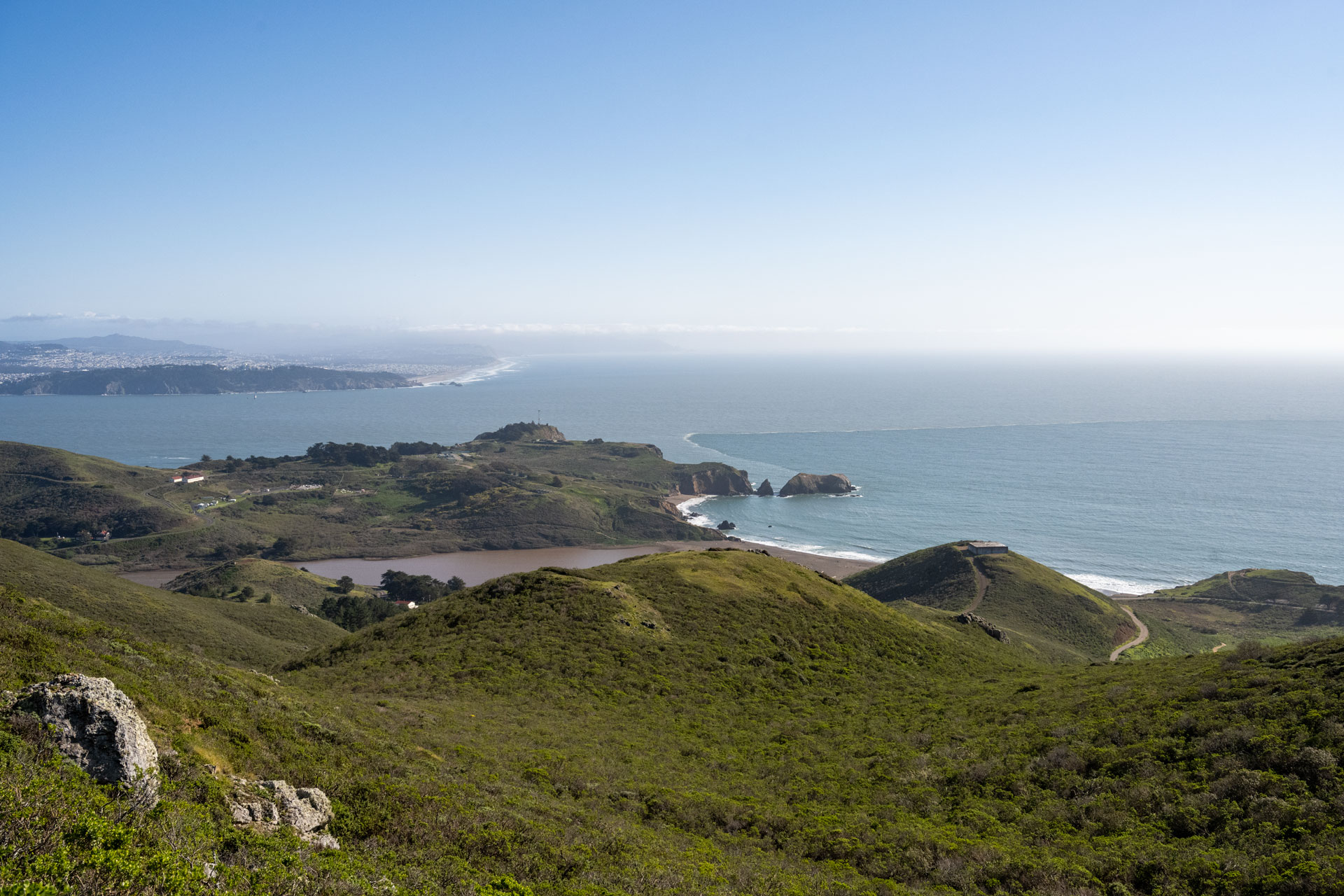
Probably one of the most famous views of the Golden Gate is the one from Battery Spencer. It’s the closest viewpoint to the bridge, with the northern tower almost hitting you in the face. Battery Spencer sits just north of the bridge, where a winding road leads you to the top of a tall bluff. From the parking area, a short pathway (less than half a mile roundtrip) takes you to an old concrete battery that overlooks the bridge and city. In addition to a bird’s-eye view of the world-famous landmark, you get a great look at downtown San Francisco to the south and a peek at Alcatraz Island to the east.


Pro tip: If you’re interested in photography, it’s best to visit later in the day just before sunset. The warm glow of the afternoon sun sets the bridge on fire just before it dips behind the headlands. Be prepared to share the space and to park further away, however, as this is the most popular time of day to visit. If you choose to visit in the morning, you’ll be shooting directly into the sun (southeast). Additionally, if Karl (the legendary San Francisco fog) happens to roll in, this can be a great spot to catch the crimson towers poking out from a sea of clouds. As luck would have it, the one time I drove past and Karl was at his best was also the one time I didn’t have my freakin’ camera in the car.
Hawk Hill
For a slightly different vantage point, head a bit further west to Hawk Hill (the parking area is labeled Top of Four Vista Points on Google Maps). This overlook (facing due east) offers a more pulled back view of the bridge and, arguably, a better look at downtown. Whether you enjoy the vista from the parking area or walk up the short dirt path to Hawk Hill, you’ll get a strikingly similar view. That few extra feet of height is advantageous for photography, though, and the walk is similar to Battery Spencer – less than half a mile roundtrip. If you’re keen to check historic batteries off your list, Battery 129 conveniently sits atop Hawk Hill. The best part, though? This overlook is significantly less busy than Battery Spencer, so it’s a great place to go if you’re not one for crowds.


Pro tip: Large sections of Conzelman Road are one-way. If you want to combine Hawk Hill with Battery Spencer, be sure to visit Hawk Hill first. If you park at Battery Spencer first, the road becomes one-way. Consequently, you have to drive back down, back through the Baker-Barry tunnel (which is one-way and tends to have a queue), and then back up to Hawk Hill. Having to make this second lap can be a massive pain in the ass (and time sink) if there’s heavy tourist traffic.
To visit both viewpoints, first park at the small lot at Hawk Hill (Top of Four Vista Points). Make sure you don’t drive beyond this, as this section of road also turns into a one-way route (winding down the headlands toward Rodeo Beach, in the opposite direction of Battery Spencer). Making that mistake would also force you to make a second lap up. If you stop at the Top of Four Vista Points lot, you can easily drive back down the way you came and then head over to Battery Spencer.
Black Sand Beach
If you’re looking to visit a black sand beach without flying to the Hawaiian Islands, you can find one right along the Marin Headlands. To reach the beach, it’s just a 0.3-mile walk from Upper Fisherman’s Parking Lot to the sand. It’s a small cove and seemingly less visited than some of Marin’s other beaches. When I stopped by on a Thursday afternoon in May, I was the only one there.

Know before you go: This is yet one more site that sits along a one-way stretch of Conzelman Road. It’s on the one-way segment beyond the Hawk Hill/Top of Four Vista Points parking area. Consequently, this could be a good place to visit after you check out Hawk Hill.
Rodeo Beach, Coastal & Miwok Trails
If you’ve read any of our other California posts, you’ll probably notice some recurrent grumbling about the lack of longer-distance, dog-friendly trails in the area. Sure, you can find a lot of short (often paved) walking paths. But it you enjoy hiking and your dog is used to 10–20 miles at whack, you’re largely in trouble. Enter: Golden Gate National Recreation Area.
With a number of dog-friendly trails within the park, we were able to first put together a loop that afforded Sanchez at least a moderate outing of six miles with just over 1,200 feet of vertical gain. It was a decent little loop, and one you might enjoy even if you’re not exploring with a pup.
The circuit begins and ends at Rodeo Beach, a little isthmus of sand bounded by the rolling waves of the Pacific and a sheltered lagoon. From the beach, the Lagoon trail first passes alongside the small inlet, and can be a great place for birdwatching. This path then links up with the Coastal and Miwok Trails, both of which wind up and down the coastal bluffs. The trails occasionally pass by old batteries and, in the spring, poppies and other colorful wildflowers abound.
If you’re looking for a shorter or longer route, an entire labyrinth of trails can be accessed from the beach. And if you’re wandering around without a pup, you’ll have many more trail options available. Additionally, if you’re just looking for a picnic on the beach, Rodeo Beach makes a pretty nice spot. If Rodeo Beach doesn’t do it for you, you can also head to Muir Beach, a bit further north. This beach also provides access to the same network of trails, so you can plan a similar outing here. If you want to visit both beaches and are up for a longer hike, the two are joined by a 5.5-mile section of the Coastal Trail. The roundtrip hike clocks in at just over 11 miles with 3,300 feet of vertical gain. This out-and-back also allows you to visit Tennessee Beach – a quiet cove where you can also bring your leashed pup. The entire section of the Coastal Trail from Rodeo Beach to Muir Beach is dog-friendly, so your pup is allowed to join you on this route.

Know before you go: If you’re hiking around this area with your doggo, you really need to take time to study the map so you can plot a pet-friendly route. In many places, dog-friendly trails link up with pet-prohibited trails, so it can be a bit of a challenge. Additionally, some trails are only dog-friendly in certain sections (e.g. Coastal, Miwok), while others are off-limits entirely (e.g. Tennessee Valley). Make sure you check the NPS website for detailed restrictions (AllTrails is mediocre at best), and stay on dog-friendly trails. And as always, remember to leash and clean up after your fuzzy buddy.
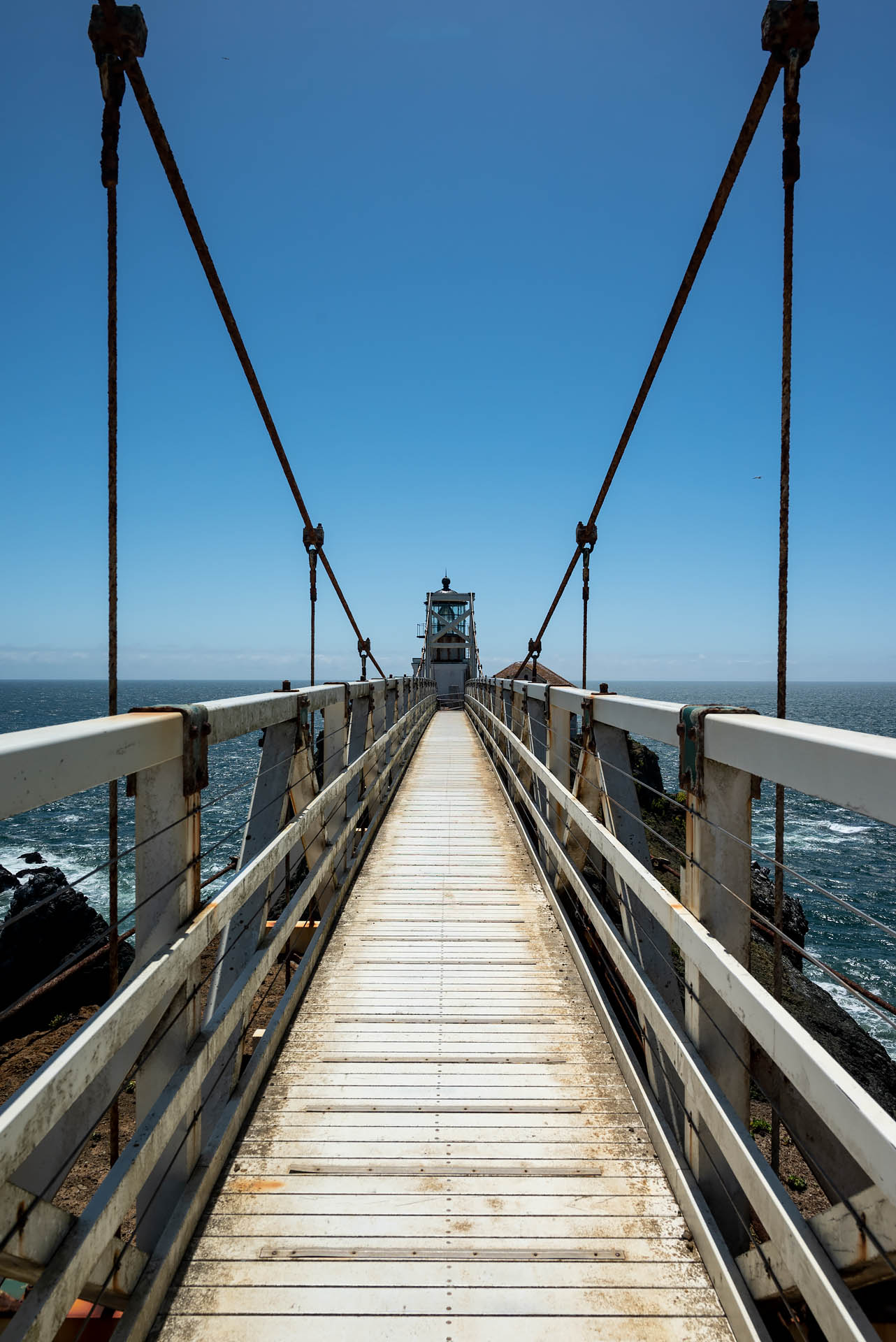
Point Bonita Lighthouse
During California’s Gold Rush years of the mid-19th century, the treacherous waters around San Francisco Bay saw an overwhelming surge in maritime traffic. Crews struggled to navigate the perilous straits, and some 300 ships ran aground during this period. To provide a safer passage for the influx of fortune-seekers pouring into the area, the government constructed the Point Bonita Lighthouse in 1855.
Only the third lighthouse to be built on the west coast, Point Bonita was set on the headlands at the mouth of San Francisco Bay, 306 feet above the Pacific. The light was positioned high on the bluffs, mirroring the stations that dotted the country’s east coast. However, San Francisco was a different monster. Here the beam of light struggled to penetrate the city’s infamous, low-hanging fog, offering little help to vulnerable seafarers. Because of this, the light station was relocated to a spot two hundred feet lower on the promontory in 1877.
In order to move the light to its current location, workers had to hand-carve a tunnel more than 100 feet long through the rocky headland. The light also became equipped with the first fog signal on the west coast. It wasn’t the blaring warning siren one would expect, however. Rather, Point Bonita’s “foghorn” was actually a surplus 24-pounder siege gun supplied by the U.S. Army. The enormous cannon was fired every half hour by its keeper, a retired Army sergeant, during periods of low visibility.


Today, the Point Bonita Lighthouse is still perched more than 100 feet above the churning currents of the Pacific. It is still an active light and is maintained by the U.S. Coast Guard. However, accessing the lighthouse today is much different than it was in the 19th century. The natural land bridge that once led out to the light eroded away during the late 1930s and early 1940s. To reach the light, a cable suspension bridge was constructed in the 1950s, echoing the design of the city’s engineering masterpiece. It’s now the only lighthouse in the country that is accessed via suspension bridge.
If you’d like to visit this unique and historic landmark, a half-mile-long trail leads out to the light, passing through the original, hand-hewn tunnel and across the 156-foot span. I have to say, I thought this was quite the charming little gem perched out on the Marin Headlands.


Know before you go:
(1) The lighthouse has fairly restricted hours. Some days of the week it’s closed entirely, some days it’s open for just a few hours, while others it’s open for up to six hours (9:30 a.m. to 3:30 p.m.). Days and times change seasonally, so be sure to check the NPS page for current operating hours before visiting. If you visit when it’s closed, you can’t access the tunnel or suspension bridge, which means you can’t actually view the lighthouse at all. NPS Staff also close up promptly at closing time, so make sure you’re there well before if you plan to spend a bit of time.
(2) The lighthouse may be inaccessible due to inclement weather. If the winds exceed 30 mph, the staff will close the suspension bridge. Onsite staff members monitor winds with a handheld anemometer for everyone’s safety. When I was there, the winds were right at 30 mph and the staff member was diligently checking his wind gauge. Just as I was finishing up my visit, they closed the bridge to other visitors.
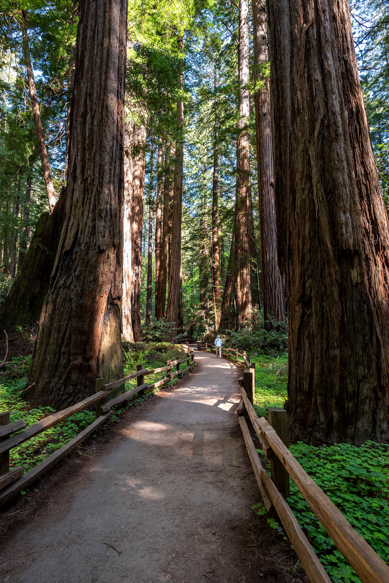
Muir Woods
Covering more than five hundred acres and sitting just twenty miles north of San Francisco, Muir Woods National Monument is home to some of the last remaining old-growth redwood groves in the Bay Area.
While redwood forests covered upwards of two million acres across Northern California prior to 1850, roughly 95% of the ancient trees have been lost to logging. The redwoods were first seen as valuable timber during the time of the gold rush, and industrial logging eventually peaked during the post-WWII economic expansion. Of the meager 5% of redwood forests that remain today, roughly 80% are now protected.
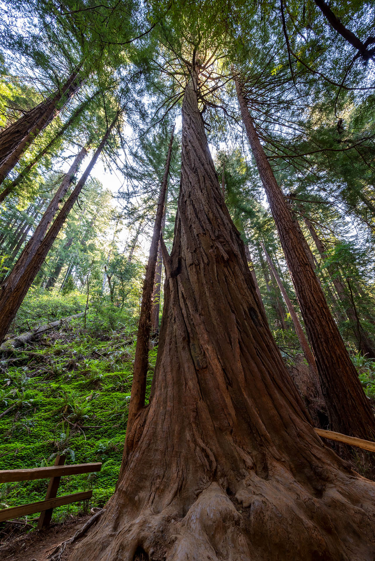
Known for their massive size and tremendous lifespans, coast redwoods are the tallest living organisms. The tallest specimen in Muir Woods stands an impressive 258 feet in height. Despite their incredible height, the trees have shallow root systems – making them vulnerable to windfall. To overcome this weakness, redwood roots can extend for 100 feet horizontally – intertwining with those of their neighbors and rendering the trees stronger together.
The average age of the redwoods in Muir Woods is between 600 and 800 years, with the oldest around 1,200 years old. While that seems like an impressive number, coast redwoods can live for more than 2,000 years.

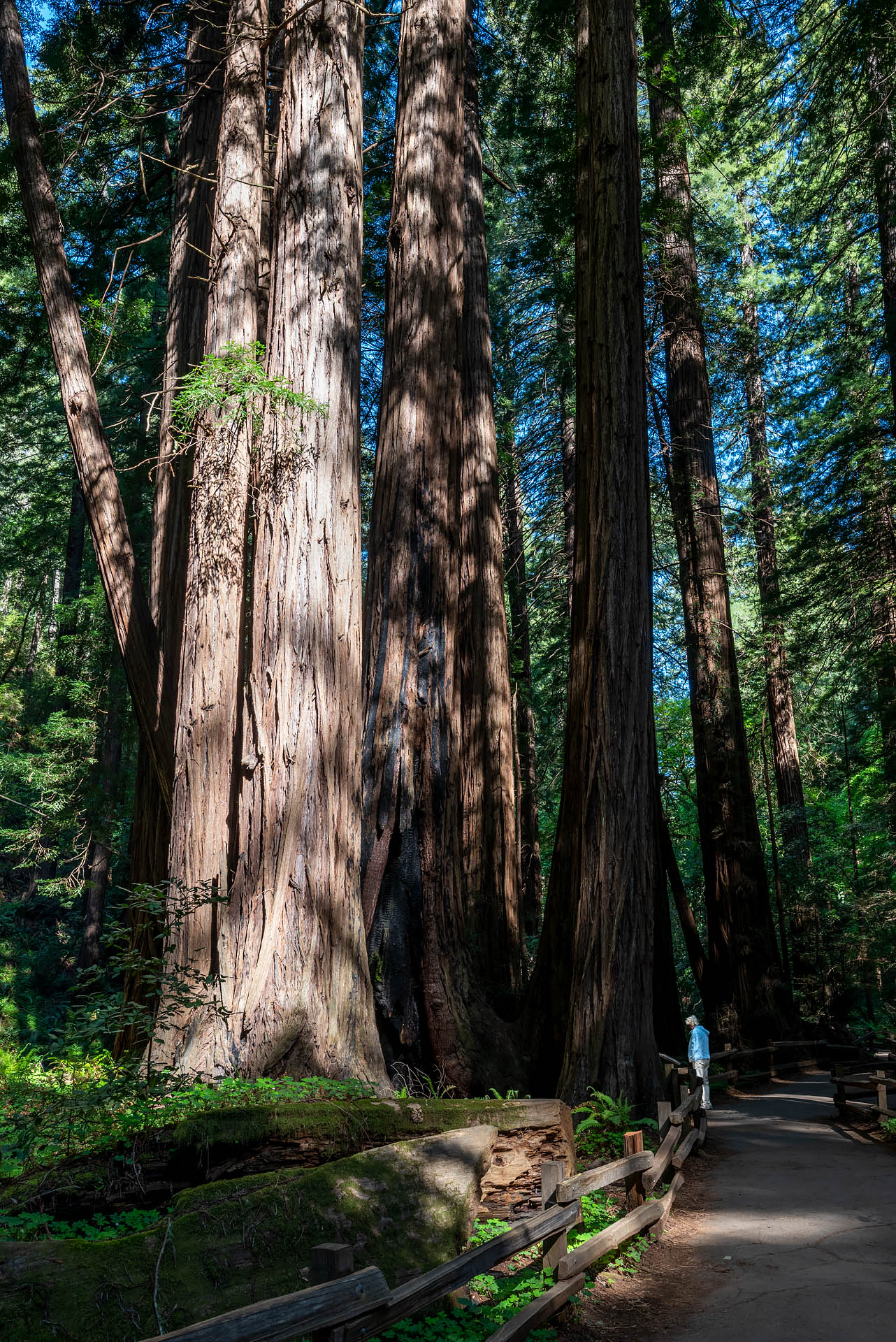

If you’re looking for a shorter hike around Muir Woods that allows you to see the Founders Grove, Bohemian Grove, and Cathedral Grove, you can make a two-mile loop by combining the Main (Fern Creek) and Hillside Trails. The trails are virtually flat, and the route loops around the park’s three core redwood groves. In the Founders Grove, near the park’s entrance, you’ll find the Pinchot Tree – one of the largest in Muir Woods. In the Bohemian Grove, you’ll find a number of burned trees that have recovered from a past wildfire.
If you visit Cathedral Grove, a beautiful stand of some of Muir Woods’ oldest and tallest trees, remember to pass through silently. The park has designated this a place for quiet contemplation and reflection, and should be respected as such. Rather than chattering away as you walk through, listen to the wind blow through the conifers. Watch the ferns dance in the sunlight. Keep an eye out for redwood sorrel, banana slugs, and mushrooms in the understory. And enjoy the quiet melody of the songbirds that call these magical woods home. For just a few minutes, resist the urge make any noise, if not for your own enjoyment, for that of others visitors looking to immerse themselves in nature’s tranquility.


For those looking for a longer outing, consider combining the Canopy View and Lost Trails with the either the Fern Creek (Main) or Hillside Trail. Whether you use the Fern Creek or Hillside leg, the routes should be roughly similar (2.6 vs. 3.3 miles) with slightly more gain (800 vs. 1,000’). If those couple options don’t suit your fancy, the park offers a fantastic summary of all route distances and descriptions on their Find Your Trail page.
Hook Fish Co.
If you’re looking for a fantastic place for a late lunch or dinner after visiting Muir Woods (or other nearby sites around Marin), pop into local favorite, Hook Fish Co. Most visitors to Muir Woods will presumably be headed back toward Highway 101, and Hook is right on the way in Mill Valley. Not only is the food here incredibly fresh and delicious, but Hook’s sustainably-minded mission is also deserving of praise: providing our community with a transparent, thoughtful source of fish and prepared seafood that empowers local fishermen.
In their quest to provide patrons with the exact story of where their fish comes from, a giant board in the restaurant lists the fishing method, port, and vessel name for each type of seafood that arrives at the eatery. I think it’s a really neat idea, and a great way to give guests a more meaningful connection to those that toiled to provide them their meal.


Hook offers online ordering for takeaway (it usually takes about an hour during the dinnertime rush) as well as dine-in options. If you want to sit and enjoy your meal, they have an absolutely gorgeous patio area that’s also dog-friendly. As for the food? It’s incredible. Every family member and friend we brought there raved about ‘the best fish tacos they’ve ever eaten.’ Hook even offers a couple of vegan options, including fresh (or fried) avocado tacos or burritos. If you enjoy seafood but have never had a fish burrito before, now’s your chance. Pair your meal with one of their thirst-quenching agua frescas, plop down at one of their shaded picnic tables, and recap the day’s adventures amongst the redwoods (or elsewhere).


ACROSS THE BAY
While everything up to this point has been north of the Golden Gate in Marin, there’s also plenty of recreational opportunities south of the bridge and even further south in San Mateo county. For those staying right in the city, The Presidio is a great place to start. Here are a couple of spots we thought were just beautiful:
The Presidio & Coastal Trail
This little excursion was my solo getaway for a few hours… and it ended up being a great one. I had to drive an hour and a half from Sonoma to SFO to drop Stephan off for an early morning flight to NC. Since it was a stunner of a morning and I’d driven all that way, I didn’t want to just to throw him out at departures and turn around. Thus, I figured I’d do some wandering and explore a new corner of the city I hadn’t seen.
With very little open at 8 a.m. on a Sunday, I decided to head to Baker Beach – a mile-long stretch of sand on the western side of San Francisco’s Presidio. Now a sprawling urban park and cultural site, the Presidio previously served as a fortified military post from 1776 to 1994. Originally a Spanish fort, the site was seized by the U.S. military at the start of the Mexican-American War. It was then used as an Army headquarters during WWII and, most recently, during Desert Storm. After almost 220 years of uninterrupted military presence, the Presidio was ultimately transferred to the National Park Service in 1994.
Sitting just south of the Golden Gate Bridge, the Presidio now offers residents and visitors nearly 1,500 acres of historic landmarks, beaches, and mixed-use space including 24 miles of trails. Admittedly, I didn’t have much of a plan when I arrived, so I just started wandering around until I improvised a short outing.
From the south end of Baker Beach, I headed up the Coastal Trail toward the Golden Gate. Paralleling Lincoln Blvd, the trail skirts the tops of the bluffs overlooking the Pacific for about 1.5 miles until it reaches the bridge.


After snapping a few obligatory photos at Fort Point, I returned to Baker Beach via the Batteries to Bluffs Trail. This route winds up and down the hillside via dirt paths and a number of wooden staircases, offering some gorgeous views looking back toward the Marin Headlands. The wildflowers were still hanging on after their incredible weeks-long bloom, and it turned out to be an unexpectedly scenic little loop.


The circuit ended up clocking in at around three miles – fairly flat mixed with a few small hills and stairs to climb. I had zero expectations when I started out, which made the scenic surprise that much more rewarding. Importantly, it was also a reminder of how much fun it is to just wander whimsically without any regimented plan or scheduled destination. I am so neurotically type A, that this is a rare – albeit wonderful – occurrence.
Pedro point
The Pedro Point Headlands encompass some 250 of land beside the town of Pacifica. Here, a small network of dog-friendly trails offer beautiful views from the towering coastal bluffs. The aptly named Bluffs Trail is particularly scenic, winding its way up and down the rolling hillsides to a striking promontory overlooking San Pedro Rock.


If you begin from the Devil’s Slide North Parking Lot, the loop trail is roughly 2.3 miles total. If you start further south at the small lot just past the Tom Lantos Tunnels, the out-and-back route is about five miles total with 700 feet of elevation gain. With the north lot closed when we visited due to storm damage, we did the longer outing. If it’s a nice day and you’re looking to spend some more time outside, we’d totally recommend the longer option.
The ‘trail’ that runs between the north and south parking areas is known as Devil’s Slide. Now open exclusively to pedestrians and cyclists, the paved 1.3-mile length of road was once part of the Pacific Coast Highway. In 2013, Devil’s Slide was closed to vehicular traffic due to safety concerns. Not only was Devil’s Slide the site of numerous accidents, with cars plunging hundreds of feet over the massive cliffs, but it was also particularly prone to landslides, resulting in frequent road closures. Consequently, the highway has now been rerouted through the newly constructed Tom Lantos Tunnels (Devil’s Slide Tunnels).


Know before you go: (1) Parking in the south lot is extremely limited, so it can fill up quickly on weekends and sunny days. (2) The bluffs around the headlands are unstable and prone to slides (especially following prolonged rainstorms), so take extra caution when walking around these areas.
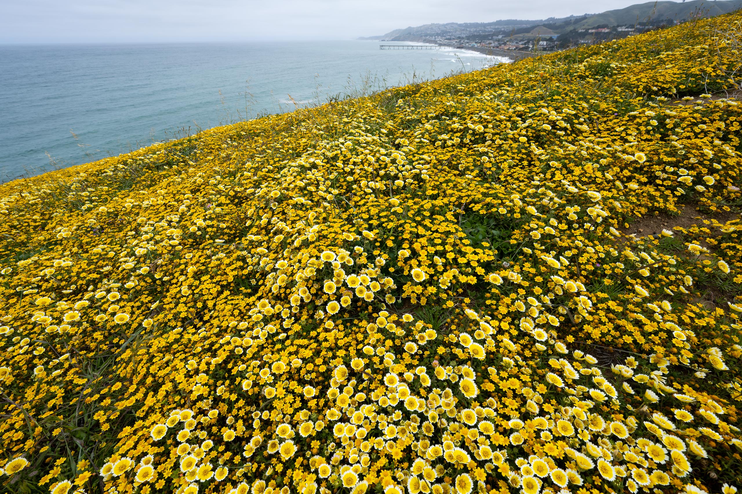
Mori Point
Located on a headland just south of the town of Pacifica in San Mateo County, Mori Point is one of the newest additions to the GGNRA. The scenic bluff can be explored via an easy loop trail, clocking in at around 2.5 miles with just a few hundred feet of elevation gain.
This year, California saw one of the best superblooms in recent memory, with colorful wildflowers exploding in nearly every corner of the state. When we visited in May, Mori Point was no exception. Arguably the best superbloom of the year in the Bay Area, the promontory was absolutely smoldering with golden blossoms. On either side of the path, California goldfields and tidy tips blanketed the hillside, contrasted by the vibrant, turquoise waters of the Pacific.


It was undoubtedly the most dense display of flowers I’ve ever seen, and it was an absolutely spectacular sight to behold. While Mori Point isn’t always draped in gold (and annual bloom numbers and timing will vary significantly depending on the season), it is still a gorgeous spot for a seaside stroll. If you do visit, just remember to recreate responsibly. This is a special little spot and should be treated as such. Stay on the trail at all times to protect the delicate vegetation and remember if you pack it in, pack it out.


Pro tip: If you enjoy IPAs, Humble Sea Brewing is just a five-minute drive from Mori Point up CA Route 1. In our opinion, they’re one of the best craft breweries in Northern California. Enjoy a seaside walk, then pop over to the brewery for a flight of their signature foggy IPAs, some light pub fare, and a little sunshine in their outdoor beer garden.

Know before you go
- Be aware of park fees. While most sites within the GGNRA are free to visit, a few require some type of entrance or parking fee. A couple of the most popular sites – Alcatraz and Muir Woods – require some type of charge. For Muir Woods, there is a $15 entry fee. The fee is waived if you hold an interagency pass (America the Beautiful) or are under 15 years of age. Be aware, however, that there is an additional parking fee at Muir Woods even if you are a passholder. And while there is no federal entrance fee to visit Alcatraz, you will have to pay for ferry fare. Current fares are $41 for adults and $25 for children. All fees & passes are summarized here.
- Get familiar with dog-friendly areas. While a number of GGNRA trails and beaches allow leashed dogs, pets are still restricted from many areas to protect native flora and fauna. In neighboring Point Reyes National Seashore, most areas do not allow dogs. If you’re unsure before you visit, refer to the National Park’s chart outlining dog-friendly areas and regulations.
- Reservations are required for Muir Woods. Due to a significant uptick in visitation numbers, the national monument implemented a reservation system back in 2018. If you want to visit the redwoods, you now need to make an advanced reservation for either private vehicle parking or the Muir Woods shuttle (seasonal operation). If you’re visiting during the busy summer months, be sure to make a reservation early; slots do book up quickly. Everything you need to know to visit Muir Woods can be found here.
- Recreate responsibly. GGNRA is home to 19 unique ecosystems that support more than 2,400 plant and animal species. Thirty-seven of these are on the list of federally threatened or endangered species. Stay on the trails, follow posted signage, pack out all waste, and don’t take your pup where he/she isn’t allowed.