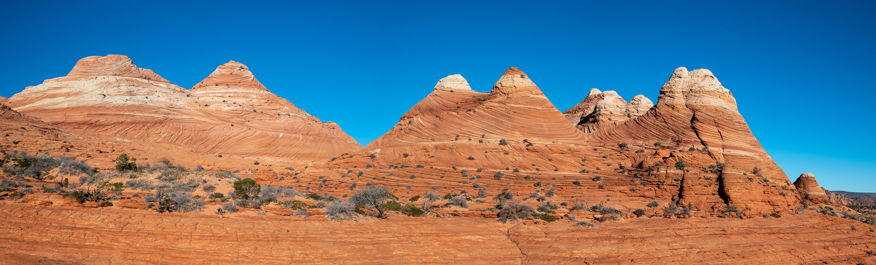
A striking sandstone formation in a remote corner of the Paria Canyon-Vermilion Cliffs Wilderness, The Wave is widely considered to be one of the most attention-grabbing sights of the American Southwest. Sitting just south of the Utah/Arizona border in an area known as Coyote Buttes North, The Wave is only accessible by a permitted, six-mile, round-trip hike.
The Wave’s unique formation began to take shape around 190 million years ago, at the height of the Jurassic Period. During this time, ancient desert sands became cemented into what’s now known as Navajo sandstone. In the millions of years that followed, continuous erosion from wind and rain sculpted the rock into the swirling strata that can be seen today.


Beating the odds
Arizona’s now-famous Wave was largely unknown until the 1990s, when various media sources unwittingly catapulted it out of obscurity. Like many world wonders, people from around the globe now endeavor to visit the celebrated site. Despite its recent popularity, hiking to The Wave is quite restricted and requires entering a lottery that issues just a few dozen permits per day. The BLM estimates that the chance of scoring a permit is somewhere between just 4 to 10 percent, depending on the time of year one applies. In 2018 (the last year I could find some semblance of data from the BLM), the number of permit applications was around 200,000. One can only assume that number has increased significantly in the ensuing years.
During our most recent cross-country drive in February, we thought we’d give The Wave’s daily lottery one more chance. While we were staying in Arizona in 2022, Stephan and I had each entered a few times, but were never successful. Now, being just next door visiting friends in Colorado, we figured we’d give it one more shot. I mean, Kanab was sort of on the way to NorCal from Denver… at least just a few hours off the most direct route west. And really, how often do you find yourself within striking distance of southern Utah? With just 16 individuals awarded permits through the daily lottery, we figured we’d be making one more $18 donation to the BLM. But what the heck, right? Support underfunded public lands and maybe we’d get lucky.
On Wednesday the 8th, Stephan and I each threw in an entry over breakfast. When I opened my email over dinner that evening and saw a congratulatory message, I was dumbfounded. As soon as I saw ‘action required’ in the subject line, my heart skipped a beat. Having never seen those words in my previous lottery results notifications, I immediately knew I’d beaten some serious longshot odds. My mind quickly began racing. Not only did we actually win, but, having applied for the daily lottery, we had exactly twelve hours to prep before going to pick up our permit in Kanab.
We weren’t exactly sure what the day was going to bring. We knew when we applied that dicey weather and road conditions made January and February the least favorable months to try to visit The Wave. Indeed, as we quickly skimmed accounts from the few weeks prior, we read report after report of The Wave being obscured by snow and House Rock Valley Road being intermittently impassable with mud. Admittedly, our excitement began to wane slightly. Would we even be able to see The Wave’s swirling bands if we hiked out there? Could we even make it out there with the Subie? Should we hire a guide? What guide? Are guides even available to book same-day? We would really rather be on our own schedule and not have a guide. Do we chance it? If we only get one shot at this, we can’t make the wrong choice and f*** it all up.
Pre-hike prep
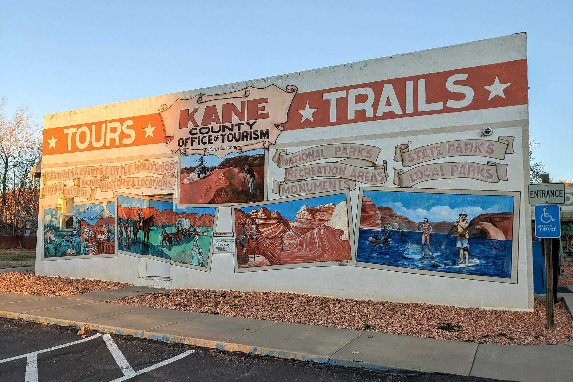
The day before our hike, we arrived at the Kane County Information Center in Kanab just before 8 a.m., about thirty minutes prior to the start of our safety orientation. Given the extremely poor odds of winning a reservation in the first place, we certainly weren’t going to risk being late and forfeiting our permit.
After printing off our screaming green permit and registering our vehicle for trailhead parking, the staff at the information center gave us a brief orientation to hiking out to The Wave. The entire thing lasted less than half an hour, and provided us with a list of guides as well as paper map of both the driving and hiking routes. While the paper copies were relatively useful, we’d definitely recommend also using Google Maps for directions to the Wire Pass Trailhead, as well as having an electronic GPS map of Coyote Buttes North stored offline.
With the forecast looking shockingly exceptional for the next 48 hours, I anxiously asked Lupie, our orientation leader, what the current trail and road conditions were like. She was zealously optimistic, assuring us that the two or three dry days preceding our arrival had drastically improved the road conditions, and that some persistent sun had melted all but a few patches of snow near The Wave. After some serious apprehension about driving out there, we felt a sudden sense of relief wash over us. Additionally, with Lupie’s vote of confidence for the capabilities of our Outback Wilderness, we decided to forgo a guide and give it a go ourselves.
With the rest of the day free to explore Kanab before our hike the following day, we decided to head out to Peek-a-boo Canyon – one of the sites recommended by Lupie. Wanting to be well-rested after nearly a week of driving cross-country and sleepless nights in hotels, we opted for this quick but scenic little excursion.


About twenty-five minutes north of Kanab, Peek-a-boo Canyon is located on a swath of land owned by local rescue Best Friends Animal Sanctuary. Although it’s somewhat remote, this gorgeous little slot can be reached via a one-mile roundtrip hike. The slot canyon itself is super short, but it is absolutely gorgeous.
As we should have expected, the real adventure ended up being the drive out there. There’s a labyrinth of sandy service roads snaking around the property, and Google Maps ended up sending us down one that was not the recommended route. After all our anxiety about The Wave, there was a moment where we thought this little side-trip just might do us in – or that we’d at least have to dig out our shovel and recovery boards. If you decide to visit Peek-a-boo Canyon, make sure you’ve got a vehicle that has some decent off-road capabilities and ask about conditions. Most people go out there with ATVs, as the roads can be pretty gnarly, and this is probably the smartest option. Depending on current conditions, the service roads you have to navigate can range from deep sand to slick snow and ice… luckily, we got both.
While the drive certainly tested our nerves a few times, our trip to Peekaboo Canyon ended up being the perfect little outing. Afterwards, we grabbed an early supper and a couple of refreshing smoothies from Asava Juice, and went back to our Airbnb to prepare for our 6 a.m. departure from Kanab. Because we were two-thirds of the way through a cross-country road trip, we had to dig out all our necessary hiking and photography gear. Additionally, Stephan decided to tear the car completely apart to haul out our shovel and tow straps, just in case there were any little surprises along the way.


Hiking The Wave
With road conditions looking favorable, we decided to attempt House Rock Valley Road ourselves and skip hiring a guide. Since we’re used to hiking 20+ miles at a whack, we figured that, worst case, we’d ditch the car on a pull-off if we got stuck and hoof it to the trail. Luckily, it didn’t come down to that. We arrived at the Wire Pass Trailhead around 7:30 a.m. without incident after an easy hour-long drive from Kanab. With the exception of the crossing at Buckskin Gulch, about halfway to the trailhead, the eight-mile trip up House Rock Valley Road was shockingly good… and exponentially better than the crazy OHV road we Stephan once managed to navigate our old Crosstrek up in the San Juans.
With some crazy amount of luck still on our side, we ended up having absolutely flawless conditions for our hike to The Wave. The morning was brisk, with temperatures hovering around 20F, but perfectly fine with a warm jacket, pair of gloves, and a rapidly rising sun. With the afternoon bringing abundant sunshine, zero wind, and temperatures that topped out in the upper 40s, you could not have asked for a more perfect day to wander around the desert.
For us, the trail out to The Wave was quite easy. The trail begins in a wash, which is obvious to follow and laden with footprints. As you exit the wash, a wooden signpost points towards The Wave trail (and again reminds you that it’s by permit only). There’s not much in the way of elevation gain or steepness, and for the first mile or so, intermittent markers guide you across the rock and sand. All signage ends about a third of the way into the hike, however, so you will need a map for the remainder of the journey. While we found the hike to be easy and straightforward, the difficulty will vary greatly depending on your abilities. If you don’t hike often or aren’t used to route finding, it could be much more challenging and/or intimidating. Likewise, weather (especially heat) will always be a critical factor. However, if you do your homework, prepare properly, and hire a guide if you’re uncomfortable attempting it alone, you’ll surely have a great time.


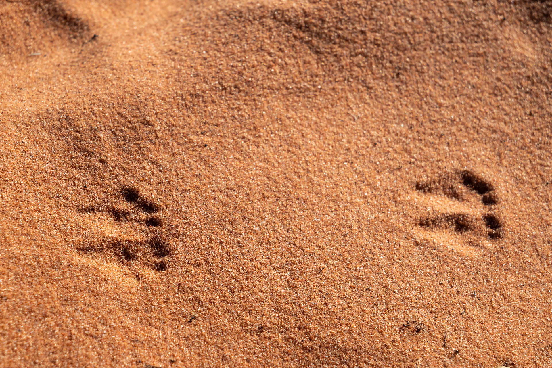
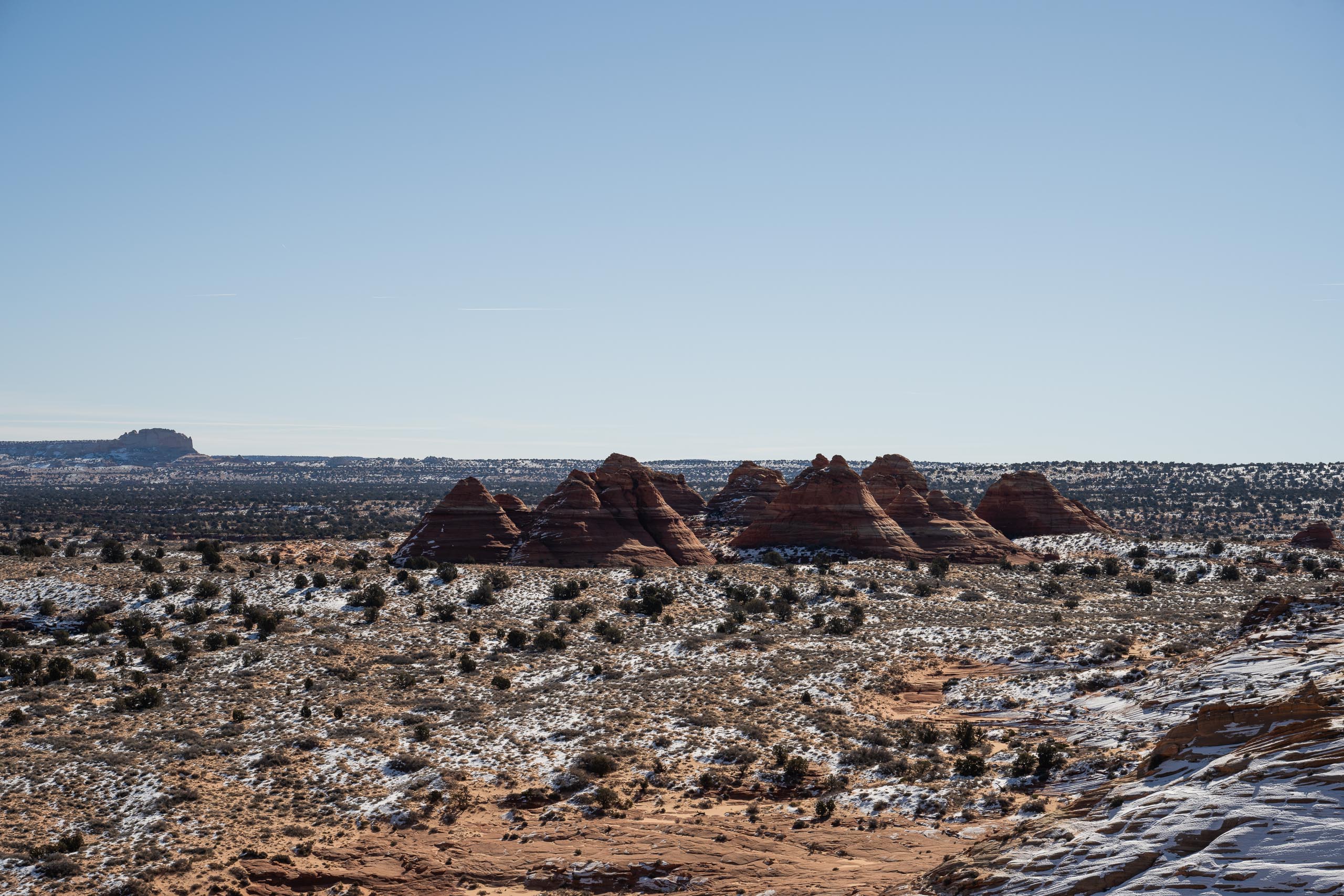
In the early morning light, the trail out to Coyote Buttes North was absolutely stunning. Sandstone teepees and undulating layers of slick rock adorn the barren, desert landscape. If you look down at the sand as you walk, you’ll notice thousands of ephemeral footprints left behind by tiny desert dwellers.


As you approach The Wave, the sand quickly gives way to fiery seams of copper and saffron sandstone. As the landscape abruptly transforms, you pass through a shadowy passageway and suddenly find yourself standing in The Wave’s colorful basin. We were shocked that no one else was around when we arrived, and it felt oddly magical to be alone in such eerie solitude. Given that we didn’t start that early, it certainly wasn’t the outcome we expected.


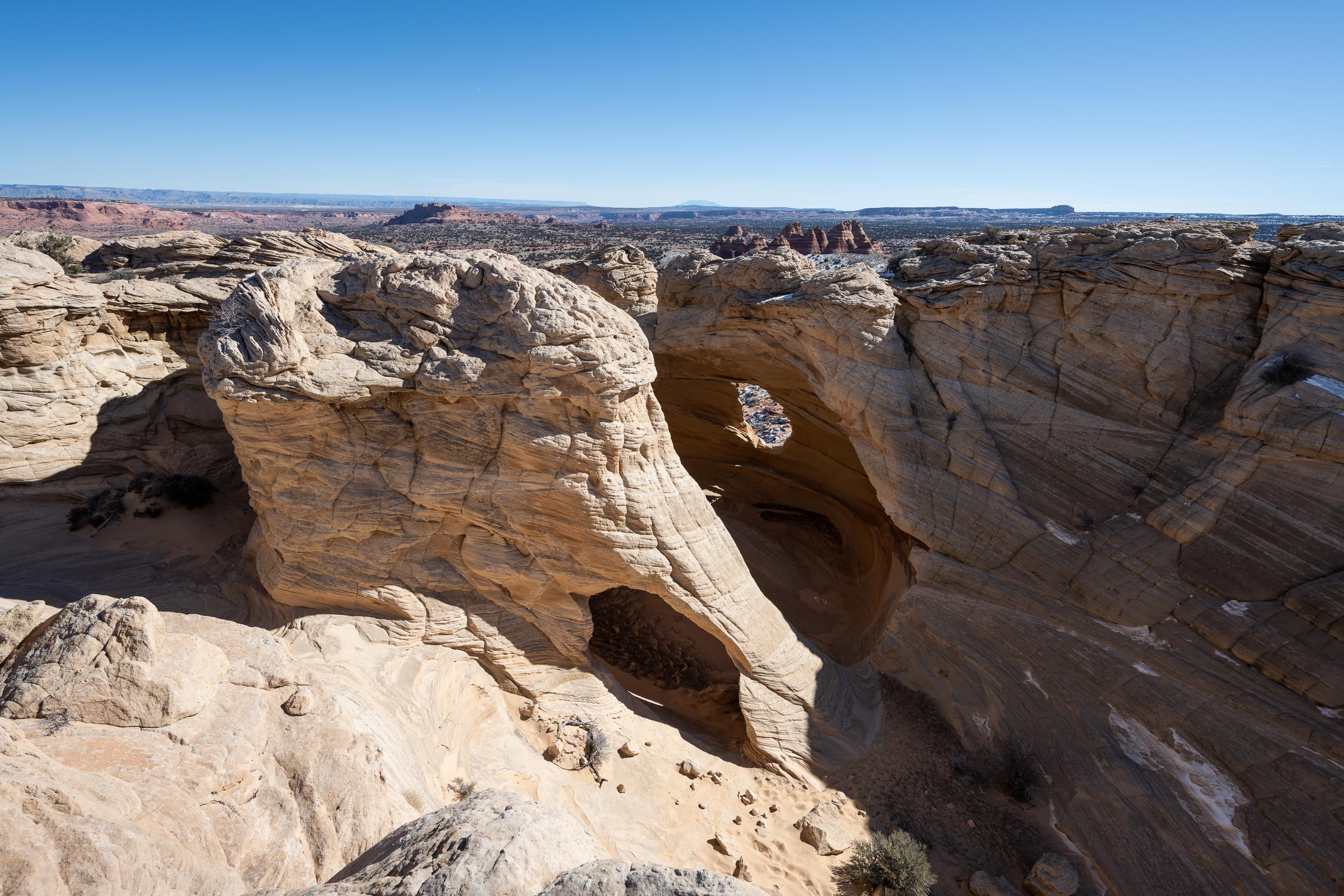
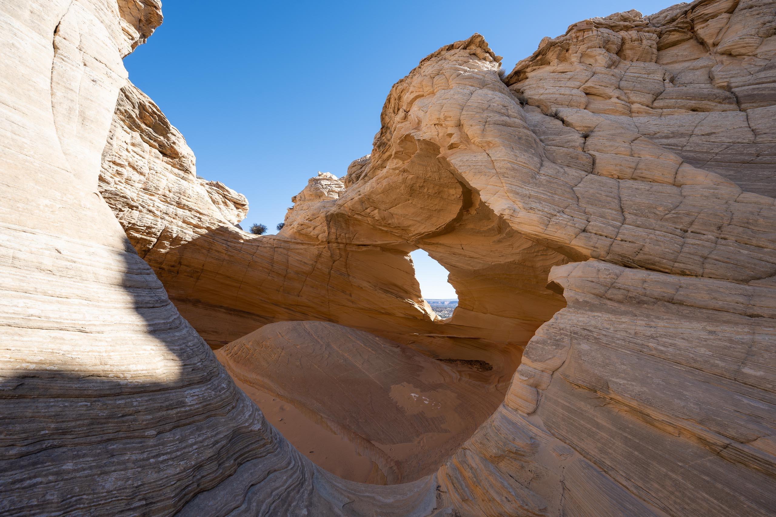
With much of the formation still hiding in shadow in the low winter sun, we continued on to explore the area beyond The Wave. As we waited for the sun’s midday peak, we wandered up and around the neighboring slickrock. We stopped to admire The Second Wave, The Alcove (home to a lone sand dune), Top Rock Arch, Melody Arch and The Window. While The Wave is undoubtedly the most iconic feature in Coyote Buttes North, the entire landscape here is pretty breathtaking. If you’re lucky enough to win a permit, definitely take some time to explore.


Around lunchtime – and the sun’s maximum – we returned to see The Wave bathed in full sunlight. To be honest, after all the hype associated with The Wave, we kind of expected to be underwhelmed. However, it really was pretty spectacular. While the number of people had noticeably picked up by early afternoon, we still only shared the spot with maybe a dozen others at best. Where all the other supremely lucky permit winners were was beyond us.


After hanging around for an hour or so while we enjoyed a leisurely lunch and some seriously awe-inspiring scenery, we went back to wandering around the now blazing collection of teepees, buttes, arches, slot canyons and hoodoos.


When it was eventually time to pull ourselves away, we loosely retraced our original steps back to the Wire Pass Trailhead. Along the way, we made a quick stop at the dinosaur footprints – an area just northwest of The Wave and pretty easy to find using the pin on Google Maps. Paleontologists believe the prints were formed by Grallators, an ichnogenus (a type of classification based on footprints) of small, carnivorous, three-toed dinosaurs that lived around 200 million years ago. If you look around a bit, you can spot a few impressions that are particularly well-preserved.


Eight hours and several hundred shutter clicks later, we found ourselves back at the Wire Pass Trailhead, feeling overwhelmed with gratitude to have had such impeccable conditions for a once-in-a-lifetime experience that’s already based on nothing other than sheer luck. We were even more grateful to have been able to take Sanchez along on our unique adventure. Although she wasn’t in love with the off-road adventure it took to get out there, she had a blast scrambling up the slick rock and sniffing for lizards in the scrub brush. First Thai street dog to ride The Wave? We have to think there’s a pretty good chance.


While you can’t begin to see the entire area in a day, twenty-four hours is all your precious permit allows. Our advice: try to fit in as much as possible. Given the absolute dearth of hikers we saw anywhere other than directly on top of The Wave, it seems like a lot of people don’t venture beyond Coyote Buttes North’s headlining feature. If you’ve got the time and the stamina, it’s totally worth taking as much time as possible to wander around this otherworldly area. After all, with an already tiny number of permit winners and steadily increasing number of applicants, it’s quite likely that you won’t be making a return trip.


Total distance: 10.5 miles (17 km)*
Elevation gain: 2,187 feet (670 m)*

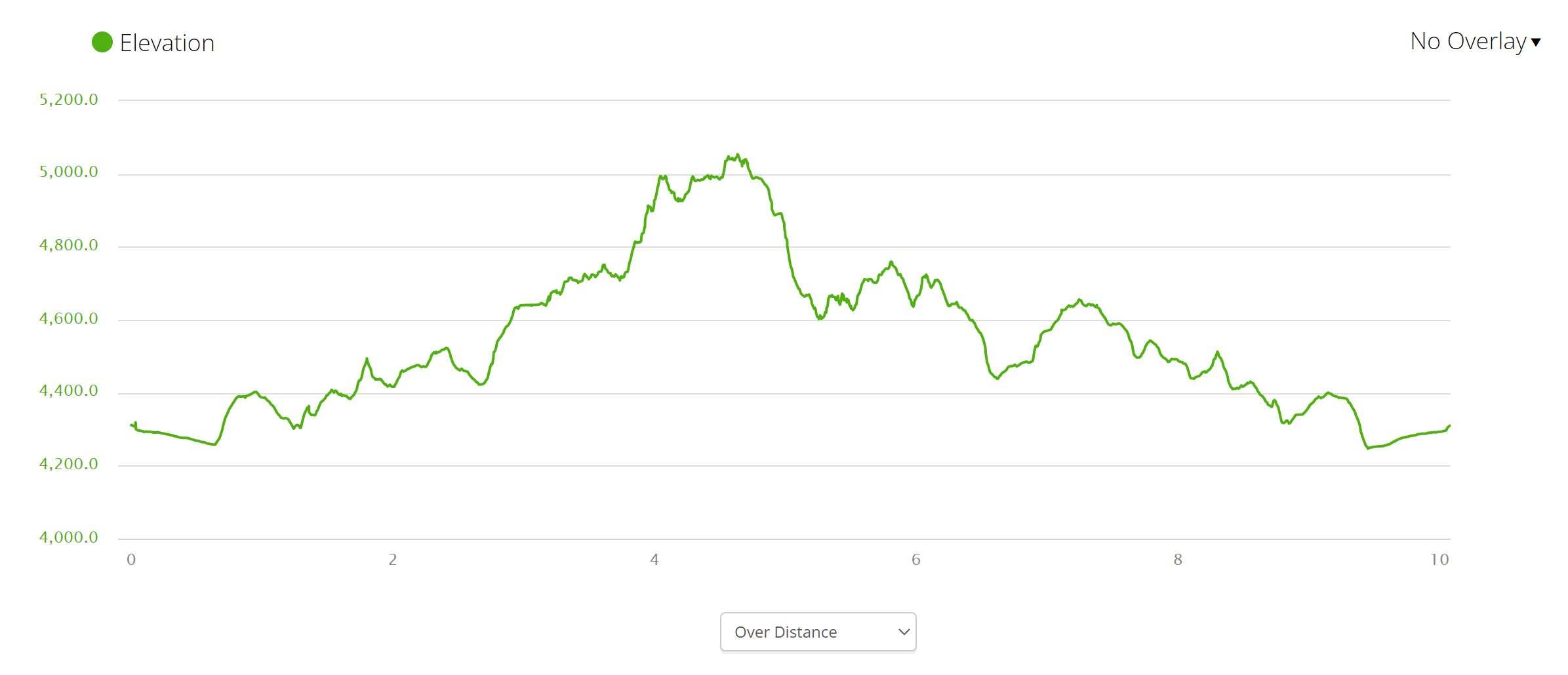
*An out-and-back hike culminating at The Wave clocks in at around 6 miles with roughly 1,000 feet of elevation gain. This is the minimum amount you will be hiking. If you plan to explore Coyote Buttes North beyond The Wave, be prepared to add both distance and elevation gain to your trip.
Applying for a permit
There are two ways to enter and win a permit to hike The Wave: (1) through the Advanced Lottery, and (2) through the Daily Lottery. In the Advanced Lottery, permits are issued four months ahead of the permit date. For the Daily Lottery, permits are issued just two days ahead of the permit date.
There is currently a $9 non-refundable fee per application to enter either lottery. If you are selected, there is an additional fee of $7 per person and dog. For my winning application, I paid a total of $30 ($9 application fee, two people at $7/each, one dog for $7).

The Advanced Lottery
Applicants are required to enter the Advanced Lottery four months before their desired hiking date. For example, if you want to hike in September, you can apply anytime during the month of May. To apply, you first need to create an account on the https://www.recreation.gov/ page. Each applicant can then select up to three dates they would like to hike The Wave. Applicants are notified via email if their permit was successful or not on the first day of the month following application (e.g. if applying in May for a September permit, you will be notified on June 1). A maximum of six people can be listed on a single permit, and dogs are also allowed to hike within Coyote Buttes North. If you win a permit, you will add your furry friend during your reservation confirmation.
Carefully read all rules, regulations, and requirements on recreation.gov’s Advanced Lottery page. If you are unable to hike on your selected permit date or are forced to cancel due to weather or road conditions, you will not be refunded and not offered an opportunity to reschedule. Because of the high demand and necessary restrictions on accessing the site, it’s a one-shot deal if you’re lucky enough to win.
The Daily Lottery
The Daily Lottery for Coyote Buttes North works very much the same as the Advanced Lottery. You begin by setting up an account on the recreation.gov page, and pay the same fees to apply and confirm your reservation.
There are two main differences for the Daily Lottery:
(1) You apply just two days before your desired permit date (e.g. if you wish to hike on Saturday 6/23, you apply on Thursday 6/21).
(2) To apply, the applicant must be within the geofence during the application window (6 a.m. to 6 p.m. two days before the permit date). The geofence extends through parts of Southwestern Utah and Northern Arizona around the Kanab and Page areas. Refer to the Geofence Perimeter Map before applying. Because of the geofence requirements, you can only apply for the Daily Lottery on a mobile device.
If your application is successful, you will be notified around 6:15 p.m. on the same day you applied. Your reservation must be confirmed by 8 a.m. the following morning or you forfeit your permit. At 8:30 a.m. the following morning, you will need to pick up your permit in-person and attend a brief safety orientation with BLM staff. Permits can be picked up at one of two locations, which you select during your reservation confirmation:
- The Kane County Information Center in Kanab, UT
- The Page-Lake Powell Hub in Page, AZ
Be sure to Read all rules and regulations here on recreation.gov’s Daily Lottery page.
The information provided here is an abbreviated summary of the rules and is subject to change at any time (info was current as of February 2023). Be sure to visit the Coyote Buttes North recreation.gov pages for either lottery, and read every section in detail.
Know before you go
- Hiking without a permit is illegal. If you try to access Coyote Buttes North without a permit, you risk a fine of between $1,000 and $10,000. Additionally, if the BLM chooses to prosecute, you could also face jail time and/or a permanent ban from future permit applications. Each of these penalties have been, and continue to be, imposed. Don’t think you won’t get caught or can just plead ignorance. There is clear and regular signage that the area is permit only, and BLM personnel and volunteer rangers regularly patrol the area.
- Be acutely aware of local time differences. Utah and Navajo Nation observe Daylight Savings Time, while the rest of Arizona does not. If you are in Arizona and not on Navajo Nation, the time will be one hour behind during daylight savings months. Permit pickup follows the time in Utah and Navajo Nation. You must be at the permit pickup location at 8:30 a.m. local time of the location you selected, which could differ by an hour depending on your physical location and the time of year. Arriving late will void your permit, so be super mindful of this.
- Your permit must be displayed on your person while hiking. The BLM provides a piece of wire to secure your paper permit to your backpack while hiking. The permit must be visible, and all members of one party must remain together at all times while hiking in Coyote Buttes North. Each person listed on the permit should also have a photo ID, in case you are stopped and asked for verification. The BLM also advises that each person take a photograph of the permit before hiking and have it available on their phone. If your paper permit for some reason goes missing off your pack, you’ll need the photo to provide evidence you are out there legally.
- Be prepared for extreme weather. Kanab averages an impressive 256 days of sunshine a year, well above the U.S. average. Summer months average around 90F, and temperatures regularly swell well into the triple digits. While winter months are much more temperate, with daytime highs averaging around 50 to 60F, this is the time of year that the weather is most likely to be poor. Cloudy days are much more numerous, and there’s a regular threat of rain or snow. Additionally, overnight lows average around 25F, and can drop even further below freezing. During the rainy months, flash flooding can pose serious safety risks. If the weather’s bad enough – and it doesn’t necessarily take much – the access road becomes impassible and the BLM restricts private vehicle access to the trailhead. There’s no refund or rescheduling on the permit, so if you’re applying during the months with dicier weather, you will be taking a bit more of a gamble.
- Check road conditions before you go. To reach the Wire Pass Trailhead, you have to drive eight miles along unpaved and only periodically-maintained House Rock Valley Road from US-89. Depending on recent weather, House Rock Valley Road can be extremely difficult to navigate. During the rainy season and winter months, the road can become completely impassible, even for those with high-clearance four-wheel-drive vehicles. Despite the road’s notorious reputation, a high-clearance two-wheel-drive car can actually make it safely to the trailhead much of the time. However, it’s certainly not guaranteed. The most troublesome section is probably the crossing at Buckskin Gulch, the road’s midpoint (4 miles from both US-89 and the Wire Pass Trailhead). The low gully is prone to flooding and seriously muddy conditions. The staff at the Kane County Information Center in Kanab can offer up-to-date information regarding road conditions, and can help advise you on the likelihood of navigating the road successfully in your vehicle. If you’re unsure about your vehicle but have experience driving in deep mud or sand, you can rent a Jeep in Kanab. If you still don’t want to chance it, you can always hire a guide to take you out there.
- Download GPS maps offline ahead of time. There is little to no cell service in this remote swath of desert, so make sure you are prepared with maps and are comfortable with some route finding. We used Gaia’s route to The Wave, and found it to be quite accurate. You can also pin some of the geological features from Google Maps offline.
- Hiking parties do occasionally get lost or disoriented hiking to The Wave. If you aren’t comfortable with route finding, navigating the dirt road, or just want a local expert to show you around the area, consider hiring a guide. There are a number of companies to choose from and you can read dozens of reviews online. Additionally, the Kane County Information Center can provide you with a comprehensive list of guides and contact information.
- You will find basically zero shade on the hike in/out, or anywhere near the Wave, so be prepared with plenty of water and sun protection. Remember: this is the desert and you won’t find water anywhere near or along the trail.
- Keep weather conditions in mind if you’re hiking with your dog. To reiterate: it can get brutally hot and there is no water available. If you’re visiting The Wave during the warmer months, not only will you need plenty of extra water for your pup, but you’ll want to be extra careful of your furry friend’s paws. The sand and rock can get extremely hot, and can easily wreak havoc on your dog’s sensitive pads. You’ll most likely want rubber-soled booties to protect against injury. If the weather’s really hot the day you hike, it may be best to leave your dogs at home. Heat stroke in animals is very real, and you may not immediately realize something is wrong. Additionally, there’s no shade where your dog can rest and cool down if he/she does overheat.
- No microspikes or metal-tipped hiking poles are allowed on the sandstone. As its name suggest, sandstone is made of sand. Consequently, it’s very soft and can be easily broken or gouged. If you need to use a pole in/around The Wave or along the surrounding rock features, it must have a rubber base. Harder, metal materials destroy the beautiful sandstone, so it’s super important to follow this rule. Make sure to keep the rubber caps on your poles for this hike. If you don’t have rubber caps, you’ll need to stash them once you get out of the sand and onto the rock.
- Leash your dog and pack out all waste. It is a privilege that dogs are able to hike out here with their people, and one that will soon disappear if people keep leaving shit everywhere. Don’t drop your waste bag because you intend to “pick it up on the way out.” Pick up the friggin’ thing immediately and carry it with you. If you can’t cope with hauling around a small bag of crap, do the wilderness area and everyone else a favor and leave your pup at home.
- Since we’re now knee-deep in this edition of ‘yes, the rules apply to everyone no matter how special you think you are,’ let’s just shorten the discussion with this: follow all rules set forth by the BLM. Like all protected areas in the country and around the globe, this is nature. It’s the wilderness. It’s a very special place. And it’s not your personal playground. People want to visit for a reason. If you can’t be respectful, all of these magical places will cease to exist. It’s just that simple. Get over any hint of entitlement you may be feeling and realize that with your permit comes a privilege, not a right.
- If you don’t win a permit for The Wave through the Daily Lottery and are staying locally in Kanab, we’d definitely recommend visiting the Kane County Information Center for information on local sites and trails. The staff there were exceedingly friendly and eager to help, and they are a really great resource for exploring the area. After our safety briefing, we hung around and talked with Lupie for a while. She is awesome and helped us plan our pre-Wave adventure day in Kanab. The internet may be great, but you can’t always beat a local resource.
- Still have questions? Even more information can be found on the BLM’s page of Need to Know items as well as their list of FAQs.