Our planet is a truly magical place – a place with an immeasurable diversity of landscapes and wildlife, and with millions of kilometers of epic paths that cut through it all. What better way to immerse yourself in all this grandeur than to lace up your boots, strap on your pack, and head out for a day on the trail?
Maybe your idea of the perfect view is an avenue of active stratovolcanoes, where rust-hued craters and jewel-toned lakes erupt from a lunar-like landscape. Or the vestiges of an extinct submarine volcano – where vulnerable, endemic species cling to a mere sliver of green amongst the relentless waves of the Tasman Sea. Perhaps you yearn for a rolling, green countryside flecked with miniature churches and humble farmhouses. Or rugged, snowcapped peaks that unfurl boundlessly to the horizon. Whatever you fancy, hopefully you’ll find a journey here that calls to you. We’ve enjoyed a number of multi-day and single-day hikes on six continents, and these were seven of our favorites:
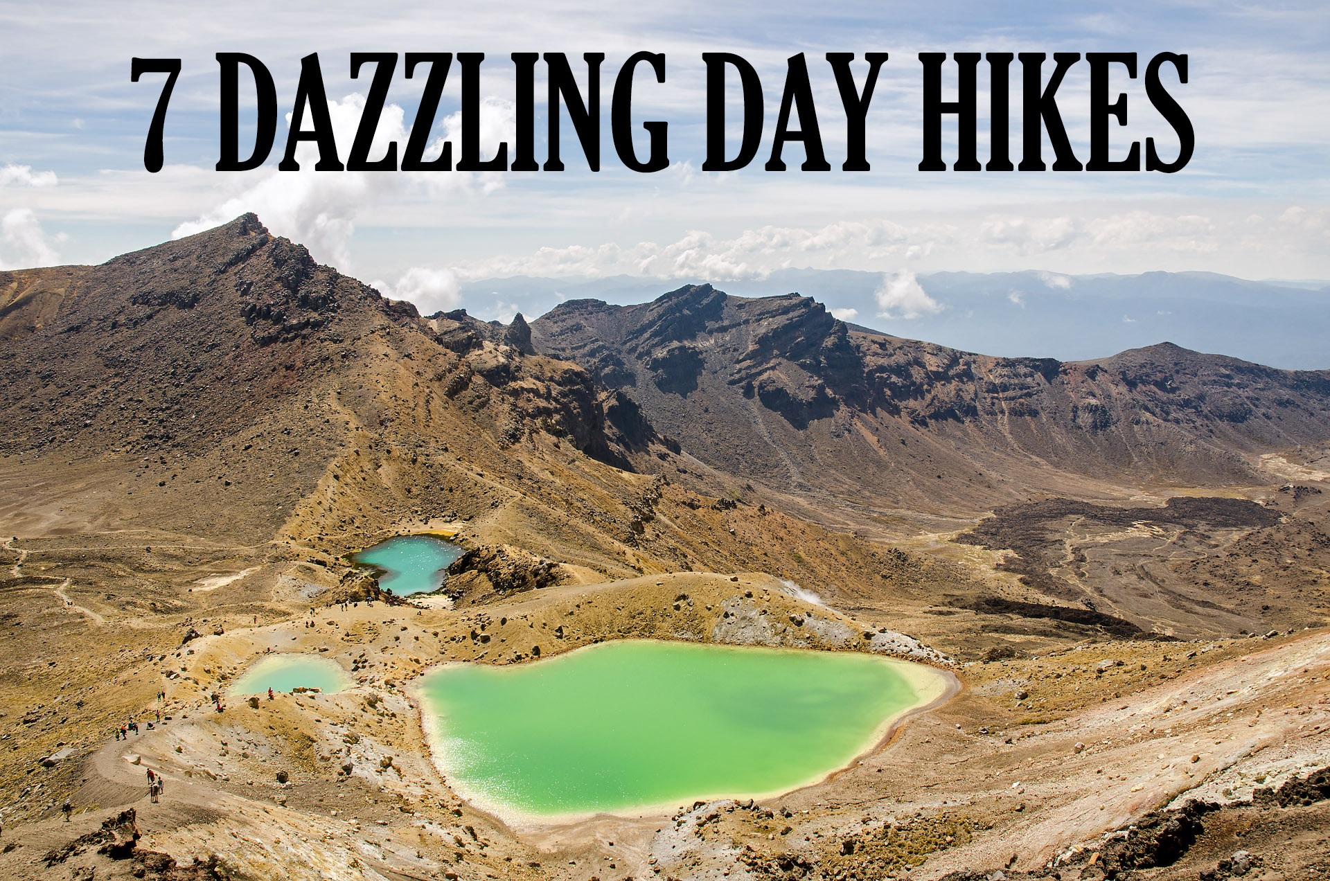
TONGARIRO ALPINE CROSSING
Location: Tongariro National Park, North Island, New Zealand
Distance: 12.1 miles (19.5 km) [Side trip: Tongariro summit – additional 1.9 miles (3.1 km)]
Elevation gain: 3,241 feet (988 meters) [including Tongariro summit side-trip]
This is considered by many to be the greatest day hike in New Zealand. With a trail that winds around three stratovolcanoes, an enormous crimson caldera, and a cluster of jewel-toned lakelets, the Tongariro Alpine Crossing seems to merit this distinction. The trail begins in the Mangatepopo Valley, cutting through the bases of Mount Tongariro and Ngauruhoe as it winds through sparse, dry vegetation and deposits of igneous rock from past lava flows.
After a moderate climb, the narrow, rock-strewn path traverses the vast floor of the South Crater, with the desolate expanse only intensifying the dramatic view of looming Ngauruhoe. With one more ascent, the trail reaches the highest, and perhaps most spectacular, point of the crossing (Tongariro summit side trip excluded) – Red Crater (6,188 feet (1,886 meters)). As the trail skirts the perimeter of the yawning crater, stained a deep burgundy hue from the iron-rich rock, in the distance, the aquamarine hues of the Emerald Lakes explode from the otherwise-barren terrain.
The trail then departs Mount Tongariro’s captivating craters, rising and falling gradually until reaching Blue Lake, a sapphire pool considered sacred to the Maori people (don’t swim or eat food around the lake). Beyond Blue Lake, the trail twists and turns as it descends Tongariro’s northern flanks, passing the Te Maari craters (a cluster of fumaroles that awoke from their 116-year slumber in 2012) before culminating in the lush Ketetahi Forest.


MOUNT BOURGEAU
Location: Banff National Park, Alberta, Canada
Distance: 15.3 miles (24.6 km)
Elevation gain: 5,018 feet (1,530 meters)
For those looking for the whole package, this hike seems to have it all – forests, lakes, a waterfall, abounding wildlife, wildflower-filled meadows, a scenic mountain pass, and an alpine summit. Not only is the trek incredibly scenic, it’s also really versatile – tramp up to Bourgeau Lake for a short hike (9 miles roundtrip), lengthen the trip to Harvey Pass for killer views (12 miles rountrip), or tack on an extra 3 miles (5 km) and 1,600’ (490 meters) of elevation gain (roundtrip from Harvey Pass) and head for Bourgeau’s summit (15 miles total).
The first section of trail climbs steadily through a dense spruce forest, passing Wolverine Creek Falls, and eventually arriving at a small clearing beside Bourgeau Lake. From the lake, the trail winds through patches of scrubby brush before rising up an exposed, rocky ridge. Atop the ridge, the path continues through lush meadows (which, in July, were still speckled with snow and ice) before arriving at a pair of shimmering lakelets.
After ascending one final ridge beyond the second lakelet, the trail opens to a stunning panorama at Harvey Pass, offering sweeping views across Sunshine Valley and Lost Horse Ridges, stretching endlessly out to the Continental Divide. From Harvey Pass, the track climbs 1,600 feet (490 meters) to Mount Bourgeau’s summit along a steep slope of packed dirt, large rocks, and some loose scree. The vistas from the crest are spectacular, with 360˚ panoramas of the majestic Rockies unfurling boundlessly into the horizon.


MOUNT GOWER
Location: Lord Howe Island, NSW, Australia
Distance: 10.4 miles (16.7 km)
Elevation gain: 2,810 feet (856 meters)
Soaring 875 meters (2,870 feet) above the turquoise waters of the Tasman Sea, Mount Gower stands like a sentry over the crescent-shaped sliver of earth that is Lord Howe Island. If you’re looking for a bit of adventure and a heap of spectacular views, look no further than Mount Gower. Climbing Mount Gower is permitted only with a guide, and on the tiny island only a couple of operators offer trips to the top. But with only one small, guided group per day allowed on the track, the journey is guaranteed to be serene.
Nature lovers will find a number of species that are endemic not only to Lord Howe, but specifically to Mount Gower’s slopes or summit. Gangly pandanus trees with massive, forked root systems create a forest labyrinth about midway up the hillside, while in the summit’s cloud forest, Little Mountain Palms (found nowhere else on Earth) reach assertively for the sky. Scrambling about these unique woodlands are a couple hundred of Lord Howe’s most-noted residents – and some of the world’s rarest – the flightless Lord Howe woodhen. Regardless of the view from the top, immersing yourself in such a special little corner of nature is simply priceless.
The trail to Mount Gower’s summit is surprisingly variable. It begins on a rock-strewn beach before quickly transitioning to a gentle ascent into the forest. Along this portion of track, you’ll find a bin full of fashion-forward, white helmets tucked in the bushes, which you’ll fasten on before hauling yourself up the first set of fixed ropes. A narrow ledge then skirts the perimeter of the hillside, offering gorgeous views to the lagoon and northern hills, before returning to a gradual slope that climbs through lush forests to the saddle. From there the trail climbs more sharply, and several sections of fixed ropes are required for scrambling up a couple sections of steep rock. Mount Gower’s summit is more than worth the effort – curious, endangered woodhens emerge from the thick underbrush to assess their transient company as you’re enveloped by sweeping island panoramas… magnificent.
Note: We climbed with Jack Shick – a gregarious, fifth-generation islander who effervesces with pride for the island and love of the climb (he’d made nearly 2,000 ascents when we visited in early 2016). We’d highly recommend taking your hike with Jack.


ZAWRAT & SWINICA
Location: Tatra National Park, Zakopane, Poland
Distance: 11.8 miles (19 km)
Elevation gain: 4,547 feet (1,386 meters)
Straddling the border between Poland and Slovakia, Tatra National Park is an outdoor enthusiast’s dream come true – prime skiing during the winter months, and more than 270 km (170 miles) of hiking and climbing trails to explore during the warmer seasons.
If you are looking for a scenic day hike with a bit of a challenge, consider the 19-km (12-mile) route that ascends two craggy summits – Zawrat and Swinica. Beginning in Kuznice, the trail ascends quickly through a dense pine forest before opening at Skupinow Uplaz, a scenic ridge dividing two immense valleys. Passing beneath the pointed peaks of the high Tatras, the trail winds through Dolina Gasienicowa and around the striking shore of Czarny Staw Gasienicowy (‘Black Caterpillar Pond’).
After ascending a rocky ridge and passing through Zawratowy Zleb, a steep couloir (gulley) that boasts another jewel-toned lake, the last section of trail rises incredibly steeply – much of it exposed and fitted with fixed chains and metal steps, similar to a via ferrata. This last kilometer is the toughest, but the sweeping panoramas from Zawrat’s 2,158-meter (7,080’) crown are a fitting reward – vertigo-inducing views of Zawratowy Zleb to one side, and to the other, the stunning ‘Valley of the Five Polish Lakes.’
From Zawrat, it’s just a short distance west along the saddle toward Swinica, with one final ~150-meters (500-foot) climb to the summit (again fitted with fixed chains and ladders). The views from atop the rugged crest are incredible, showcasing the beauty of the vast Ticha Dolina (‘Silent Valley’), and the serrated peaks of the Slovakian Tatras. After a steep descent down the opposite side of Swinica to the saddle (including a final stretch of chains), a more gradual slope descends the saddle and finishes through the western swath of Dolina Gasienicowa.


ALPE DI SIUSI (SEISER ALM)
Location: Dolomiti National Park, Passo Gardena, Italy
Distance: 16.4 miles (26.4 km)
Elevation gain: 4,091 feet (1,247 meters)
Europe’s largest mountain plateau, Seiser Alm (Alpe di Siusi) in South Tyrol offers an impressive network of hiking trails covering some 450 km (280 miles). While many trekkers opt for multi-day hikes, overnighting in the many rifugios along the trails, it is also possible to build your own day hikes, such as the route described here.
Our accommodations were in Ortisei, a small village in Val Gardena. As it’s nestled in the valley some 1,000 meters (3,000’) below the surrounding peaks and alpine meadows, a sleek cable car quickly hauls passengers from the town’s center up to Alpe di Siusi.
The stunning scenery of the high plateau envelops you instantly – jagged spines of alpine peaks rise from and endless expanse of undulating, green hills. We chose to hike toward the Sasso Lungo Group, comprised of the imposing, serrated peaks of Sasso Piatto, Sasso Levante, and Sasso Lungo. The trail gently rose and fell over grassy hillsides, passing rustic farms, gurgling streams, quaint cabins, and even a tiny church set against the dramatic backdrop of Sasso Piatto’s summit. After arriving at the base of Sasso Piatto, we continued around the backside of the barren peaks where we were greeted by a boundless view of rugged, snow-capped mountains. Though the views begged us to continue indefinitely along the endless stretch of trail, we eventually had to head back.
Our track: We followed route 9 from the lift to the Rifugio Sasso Piatto at 2,300 m (7,550’). We continued to the right of Sasso Piatto, following trail 557 around the back of the mountain. After walking as far as time allowed, we returned on 557 and 9 until the trail intersected with 531. We opted to follow 531 to the right, returning to the cable car station via trails 531/30/9.


HÖRNLIWEG
(MATTERHORN BASECAMP AT HÖRNLIHÜTTE)
Location: Zermatt, Switzerland
Distance: 5.7 miles (9.2 km)
Elevation gain: 2,323 feet (708 meters)
A seemingly classic hike in Zermatt’s tiny corner of the Swiss Alps, the trek to Hörnlihütte – the Matterhorn basecamp – is nothing short of spectacular. The trail begins at Schwarzsee and is accessed via the Matterhorn Express, a lift that climbs the scenic ~950 meters (3,100’) from Zermatt’s town center in the Matter Valley.
Under the pervasive peak of the Matterhorn, the trail passes by the sapphire ripples of Schwarzsee Lake before climbing alongside an expansive glacial valley. Eventually, the trail snakes around to the more northern face of the ridge where, continually shaded from the sunlight, the packed trail transforms to a slick, snow-covered track. Here, fixed ropes assist as the trail ascends more steeply over slippery sections of snow and ice (and although we didn’t use them, crampons would be a practical consideration as some sections are slick and exposed).
Nearing the base camp, the trail makes an eastward turn, and the final rocky ridge to Hörnlihütte abruptly loses the slick snow cover as the track reemerges into the sunlight from the shadowy northern face. Perched at the precipice of the Hörnligrat, the Matterhorn’s famed northeastern mountaineering ridge, Hörnlihütte overlooks an expansive glacial valley, with the fingerlike projections of the Furgg, Theodul, Triftji, Breithorn, and Gorner Glaciers spilling into the russet-hued basin. At 3,260 meters (10,696 feet), Hörnlihütte’s expansive sundeck offers the perfect lunch spot, with unsurpassed views of the 4,000-meter massifs of the Pennine Alps in the distance, as well as the bowed summit of the 4,478-meter (14,692-foot) Matterhorn looming overhead.


PARADISE VALLEY/LAKE ANNETTE/SENTINEL PASS/VALLEY OF THE TEN PEAKS
Location: Banff National Park, Alberta, Canada
Distance: 10.6 miles (17 km)
Elevation gain: 2,922 feet (890 meters)
Note: For this hike, we combined three routes: Lake Annette (3.7 miles one way); part of the Paradise Valley trail (1.9 miles) & Sentinel Pass connector (1.4 miles); and Larch Valley/Valley of the Ten Peaks (3.6 miles one way). Because this route ends at the Moraine Lake car park, you will need to find a ride back up Moraine Lake Road (~5 miles) to the Paradise Valley trailhead. If you don’t have a second vehicle and don’t want to hoof it, the car park is pretty busy, and it’s quite easy to hitch the few miles back up the street.
A close runner-up to Mount Bourgeau, we simply had to include a second hike from Alberta’s stunning stretch of the Rocky Mountains. The trails here are just so magnificent that it makes one seriously consider a move to the nearby city of Calgary.
Beginning at the Paradise Valley trailhead (parking lot) off Moraine Lake Road, the wooded track ascends gently through dense evergreens for nearly four miles before reaching Lake Annette – a crystalline pool of blue-green water exploding from the verdant backdrop. From here, the Paradise Valley/Giant Steps trail leads out of the forest and across a rocky ridge overlooking the boundless green expanse of Paradise Valley. The trail toward Sentinel Pass then makes an abrupt left (to the southeast) before vanishing in a steep wall of scree.
This 1.4-mile connector from the Paradise Valley/Lake Annette route up to Sentinel Pass and the Valley of the Ten Peaks can be a bit of a challenge if you aren’t used to scrambling. Be prepared not only for a prolonged scramble up unsteady rock, but also for some route-finding, as the trail all but disappears in the rockfall on the north side of Sentinel Pass, between Mount Temple (11,621’) and Pinnacle Mountain (10,062’).
Upon reaching Sentinel Pass (8,564’), you are generously rewarded with sweeping panoramas of Paradise Valley to the northwest, and Larch Valley/Valley of the Ten Peaks to the southeast. The pass is a fantastic place to stop for some lunch and enjoy the breathtaking scenery. While the Paradise Valley trail and scramble up to Sentinel Pass were all but deserted, there were several groups atop the pass, all arriving via the more-traveled Larch Valley trail from the opposite (south) side of Sentinel Pass.
To that end, the descent down the Larch Valley trail on the other side of the pass is uncomplicated, as the track is now a well-defined series of switchbacks. At the bottom of the pass, the trail flattens, winding around the Minnestimma Lakes and through the Larch Valley. From here, gorgeous vistas of the Valley of the Ten Peaks envelop you until the trail falls back into the forest, ultimately descending to the shores of Moraine Lake.


