After landing in Calgary, Alberta, we headed west to the Canadian Rockies for our 8-day, hiking-focused trip! We spent five of those days exploring the incredible mountains and lakes of Banff National Park, Canada’s oldest national park, about 2 hours (110 miles) west/northwest of bustling Calgary. Because of its scenic beauty, we decided to make the hamlet of Lake Louise, in the heart of Banff NP, our home base.
En route from Calgary to the Lake Louise area, we made a few stops along the Trans-Canada highway, including a quick stop in the town of Banff (1.5 hours west of Calgary). A scenic mountain town, we were surprised at how ridiculously crowded the tiny downtown was, even for a peak-season, summer tourist destination. Being dedicated microbrew enthusiasts, our primary reason for stopping here was to hit up Banff Ave. Brewing Company for a sampler and a quick lunch. While we are both typically fans of hop-heavy IPAs, I think we both enjoyed their unique take on a blonde ale brewed with Saskatoon berries (berries of primarily western Canada physically resembling blueberries).

From Banff, we continued 40 minutes northwest to Lake Louise, making a couple additional stops along the way to take in the scenery. Just up the road from Banff were the Vermilion Lakes, situated at the base of Mount Rundle and Sulphur Mountain and along the tracks of the historic Canadian Pacific Railway. It was quite overcast and the wrong time of day for good birding, so we continued along Highway 1 until we reached a scenic overlook along the Bow River. It was our first glimpse at the pristine, glacial-fed waters of the Canadian Rockies and we were immediately taken. It was the most beautiful river I’d ever seen – an unbelievably vivid shade of aquamarine that looked almost out of place against the deep green pines and shadowy peaks. Vibrant, purple lupine dotted the banks of the translucent river, and adorable ground squirrels scuttled about the evergreen branches and riverbanks.


Once we arrived at Lake Louise, we dedicated the majority of our time to exploring the extensive network of hiking trails. It was incredibly difficult to choose from the numerous day hikes, as most treks seemed to offer some type of spectacular scenery, from mountain vistas and blooming meadows to glacial lakes and cascading waterfalls. We ultimately selected five hikes within Banff NP (brief hike reports below), during which we gained 14,238 feet over 48 miles. I think we both agree we’d love to go back and do nearly every day and multi-day hike; it’s just a magnificent place to be outdoors. Atop Mt. Bourgeau, we met a pair of friends from Calgary who drive over most weekends to hike… what a fabulous park to have in your backyard! That said, we were shocked to find so few people on the hiking trails, especially since we were there at the end of July. With only a couple of months without snow cover on many trails, we expected to find the routes congested with summer hikers. Rather we actually found a good bit of solitude on the paths, as it seemed most visitors clung to the main, roadside views and short walks.
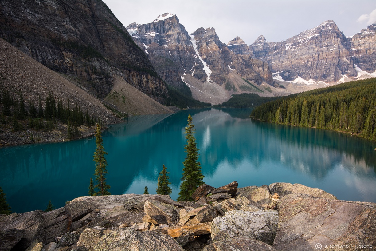
When we weren’t reveling in the breathtaking backwoods trails, we were gazing at the picturesque mountain lakes. Lake Louise and Moraine Lake, two of Canada’s most iconic lakes, glisten with striking cerulean hues. Rock flour, mineral-rich silt from glacial erosion, gives each lake its distinct, iridescent blue shade. While Lake Louise seems to be the more admired of the two, I was just captivated with Moraine Lake. One of my ‘Life List’ sites, the vibrant water and dramatic backdrop of the Valley of the Ten Peaks was just unsurpassed. The Moraine Lake Shoreline Trail (1.8 miles) was a great little out-and-back walk that hugged the perimeter of the northern and western shores of the lake, leading to the rushing inlet where the Wenkchemna Glacier flows into the lake’s southwestern corner. Appropriately, The Rockpile, the lake’s namesake glacial moraine (a deposit of displaced rock from a shifting or retreating glacier), overlooks the northern shore, providing perhaps the most photographed and unspoiled view of the extraordinary landscape.


[Note: Go to the lakes in the early a.m. (before sunrise or very shortly thereafter) to avoid crowds and to enjoy the mountainscapes illuminated by the morning sun. If you wait until afternoon, the tourists at the lakeshores are like famished ants swarming onto a discarded lollipop (especially Lake Louise).]
After several days of exploring the Lake Louise area, we headed north up the Icefields Parkway to Jasper National Park, stopping along the northern edge of Banff National Park to check out a couple more sights, including the viewpoint for Peyto Lake. Another sparkling, turquoise pool, Peyto Lake curls around the eastern slopes of Cauldron Peak. At its southern shores, the lake is fed from runoff from Peyto Glacier, an extension of the Wapta Icefield. While the overlook is quite scenic, it is also unbelievably crowded. A short, paved pathway leads up to the viewpoint from the highway, perfect for the throngs of tourists looking to snap a quick shot of something pretty and move on. While we didn’t have time to check out the nearby hikes, I’m sure getting off the (quite literally) beaten path would have afforded a more tranquil view of the pristine waters. Only ten minutes up the road we pulled off into a small, unmarked parking lot for a snack and to use the “facilities” (see also: bushes), as we certainly couldn’t stand the hordes at Peyto Viewpoint. A secluded, dirt path led us down to Waterfowl Lake. Fed by the rushing waters of the Mistaya River, an outflow of Peyto Lake, the pale green waters provided a much more relaxing setting for stretching our legs before our next stop in the southern corner of Jasper NP.


PARADISE VALLEY / LAKE ANNETTE / SENTINEL PASS / VALLEY OF THE TEN PEAKS
Distance: 10.6 miles
Elevation Gain: 2,922 feet
Rating: ![]()
![]()
![]()
![]()
For this hike, we combined three routes: Lake Annette (3.7 miles one way), part of the Paradise Valley trail (1.9 miles) & Sentinel Pass Connector (1.4 miles), and Larch Valley (3.6 miles one way).
We began at the Paradise Valley trailhead (parking lot) off Moraine Lake Road. The trail ascended gently through the thick forest for roughly four miles before we reached Lake Annette. The transparent, aquamarine water of the isolated lake popped against a background of verdant, tree-covered slopes. From here, we continued on the Paradise Valley/Giant Steps trail, which led us out of the forest and across a rocky ridge overlooking the endless, green expanse of Paradise Valley. The trail toward Sentinel Pass then turned abruptly to the left (southeast), before vanishing in a steep wall of scree. We stopped and stared at the mass of loose rock, conceived a general, visual plan of how we’d ascend, and began our scramble.


The 1.4-mile Sentinel Pass Connector from the Paradise Valley/Lake Annette route to Sentinel Pass/Larch Valley can be a challenge if you aren’t used to scrambling. Be prepared not only for a prolonged scramble up unsteady rock, but also for some route-finding, as the trail all but disappears in the scree on the north side of Sentinel Pass, between Mount Temple (11,621’) and Pinnacle Mountain (10,062’).
Upon reaching Sentinel Pass (8,564’), you are rewarded with sweeping views of Paradise Valley (to the northwest) and Larch Valley/Valley of the Ten Peaks (to the southeast). This is a great place to stop for lunch and enjoy the breathtaking scenery. While we saw virtually no one on the Paradise Valley trail (and no one on the scramble), there were several groups atop the pass, all arriving via the more-traveled Larch Valley trail from the south side of Sentinel Pass. One couple asked where we suddenly appeared from, and we pointed and said, “From that way.” They looked somewhat bemused and replied, “You came up that?!”


The descent down the Larch Valley trail on the other side of the pass is uncomplicated, as the trail is now a well-defined series of switchbacks. At the bottom of the pass, the (now level) trail winds around the Minnestimma Lakes and through the Larch Valley, adorned with wildflowers in summer. From here, take in the gorgeous vistas of the Valley of the Ten Peaks. The trail then dips downhill into the forest, ultimately descending to the shores of Moraine Lake.


Pros – Varied scenery*, gorgeous lake, stunning views from Sentinel Pass into Larch Valley
Cons – Swarms of mosquitoes at Lake Annette (don’t forget insect repellant); need to hitch back to Paradise Valley trailhead from Moraine Lake (easy to do from the bustling parking lot)
*Note: Although our modified route cut off the last ~1 mile of the Paradise Valley trail (including the Giant Steps waterfall), we think combining the two hikes provided much greater scenery than doing Paradise Valley/Lake Annette as an out-and-back. In hindsight, it would have been reasonable to add 2 miles to the hike to see Giant Steps, then backtracking to the scramble to Sentinel Pass.
BOW GLACIER FALLS
Distance: 5.6 miles
Elevation Gain: 485 feet
Rating: ![]()
![]()
A short, easy walk with virtually no elevation gain, we decided to hike the Bow Glacier Falls trail at the last minute. Our original intent was to begin the Helen Lake route early in the day, but the forecast called for low cloud cover, and we didn’t want to miss the incredible views we had read about. We therefore opted for Bow Glacier Falls as it was a low elevation hike, good for a cloudy morning, and also because it would only take a few hours, leaving our afternoon free for Helen Lake if the weather improved (the trails are only a few miles apart on the Icefields Parkway).
The level trail hugged the shoreline around Bow Glacier Lake, affording a nice view of the vivid, turquoise water. After traversing the northwestern edge of the lake, the trail followed the sandy riverbed where the nearby falls form the headwaters of the Bow River. After climbing a small outcropping (a staircase leads you over the canyon), the path again levels off and continues along the (now more rocky) bed to the falls, a rush of glacial meltwater cascading 505 feet down the craggy rock face.


Pros – Nice panoramas of Bow Glacier Lake and Bow Glacier Falls
Cons – Fairly boring route, not much variation in scenery, few flowers and birds
HELEN LAKE / CIRQUE PEAK
Distance: 8.7 miles
Elevation Gain: 2,298 feet
Rating: ![]()
![]()
![]()
![]()
The Helen Lake trail is a nature lover’s paradise, boasting spectacular mountain views, a pristine lake, and rolling meadowlands teeming with colorful wildflowers and playful hoary marmots. About 30 minutes north of Lake Louise on the Icefields Parkway, the trailhead is accessed via a small parking lot across from the Crowfoot Glacier viewpoint.
The trail began with a moderate ascent through a pine forest, eventually reaching a small clearing that overlooked Crowfoot Glacier, towering above the brilliant, turquoise waters of Bow Lake. As we continued to climb above the tree line, the views opened to a range of sharp, craggy peaks (including Bow Peak) and rolling green hillsides of Bow Valley that extended as far as we could see.


Once out of the forest, the landscape transformed to a lush, undulating meadowland dotted with clusters of columbine, Indian paintbrush, and anemone. The trail crossed over a small stream and gradually zigzagged up the hillside along Dolomite Peak. At the end of the trail, Helen Lake awaits – a small pool of deep blue water tucked in amongst the lofty peaks. Here we paused to watch the marmots chase each other around the meadows, some gathering enormous mouthfuls of grass before scampering off into the rocky slopes. For more spectacular views of the countryside, the trail continues to the right of Helen Lake, ascending a short scramble to Cirque Peak.


Pros – Stunning mountain views, abundant wildflowers and adorable marmots in Helen Lake meadowlands
Cons – Much of the trail is forested (patience required if seeking mountain vistas)
SADDLEBACK / FAIRVIEW MOUNTAIN / FAIRVIEW LOOKOUT
Distance: 7.8 miles
Elevation Gain: 3,515 feet
Rating: ![]()
![]()
![]()
While not technically challenging, this steep trail will intermittently test your patience and resolve. Considered one of the finest vantage points of the Upper Lake Louise area, Fairview Mountain towers over the southern shores of Lake Louise.
The Saddleback/Fairview Mountain trail is accessed from the Lake Louise parking area and climbs quickly through the forest, away from the throngs of people crowding the lakeshore for a quick snapshot of the azure water and adjacent, iconic Chateau Lake Louise. After ascending through the tall, evergreen trees, the trail wraps around a ridge, with clear views of the Lake Louise town center. The trail continues through a forest of alpine larches to Saddleback, a tree-covered pass offering views of the surrounding peaks. Many hikers stop here and head back to Lake Louise (5 miles round-trip), but for the best views, follow the trail to right for the Fairview summit.
From Saddleback (7,642’), it is an additional one mile hike to Fairview’s summit (9,003’) ascending the southeast slope of Fairview Mountain. The difficulty increases slightly as the now steep path is poorly-defined and comprised of loose scree and slick sand. Keep trudging along and stop frequently to take in the views; the slope is totally exposed, giving way to commanding views of the surrounding summits, including Haddo Peak, Mt. Aberdeen, and the Aberdeen Glacier. Also take a moment to look back down at Saddleback, a verdant swatch that is now dwarfed by the imposing peaks. Atop the summit are panoramic views of Mt. Temple and neighboring glaciated mountains of the Lake Louise/Moraine Lake area. Peering down the northern slope gives a new perspective of the turquoise Lake Louise, now one vertical kilometer below.


Pros – Peek-a-boo view of Lake Louise from the summit, view of Mt. Temple
Cons – Limited scenery (especially) if stopping at Saddleback, lots of slippery scree from Saddleback to summit
MOUNT BOURGEAU
Distance: 15.3 miles
Elevation Gain: 5,018 feet
Rating: ![]()
![]()
![]()
![]()
![]()
This is really the trail that has it all – forests, lakes, a waterfall, abounding wildlife, meadows filled with beautiful wildflowers, a scenic mountain pass and an alpine summit. The round-trip hike to Mount Bourgeau’s summit is just over 15 miles with 5,000 feet of elevation gain, so be sure to plan to dedicate a full day (7-10 hours). The parking area for the Mount Bourgeau trailhead is well-marked along the southbound side of the parkway between Lake Louise and the town of Banff (27 miles (25 minutes) southeast of Lake Louise; 8 miles (10 minutes) northwest of Banff).
In addition to being incredibly scenic, this hike is also versatile – you can hike to Bourgeau Lake, Harvey Pass, or all the way to the summit and still enjoy some nice scenery. For a shorter, easier hike, do the round-trip to Bourgeau Lake (9 miles). To take in amazing views of the Canadian Rockies, lengthen the trip and head to Harvey Pass (12 miles round-trip). For unbelievable mountain views, make the scenic climb to Mount Bourgeau’s summit (1,600’ additional elevation gain, 3 miles roundtrip).
The trail begins by ascending through a vast spruce forest en route to Bourgeau Lake. A wooden footbridge crosses Wolverine Creek near a small set of falls, tumbling down the forested hillside. The trail continues to rise, eventually entering a small clearing at Bourgeau Lake, a charming little lake with curious ground squirrels scurrying about its shores. We stopped here for a quick snack and promptly made a furry friend. Even though we refused to feed the little one, she still seemed quite happy to visit with us and explore our gear.


From here, the trail twisted and turned through some scrubby brush before heading up to a rocky ridge. The path was reasonably stable, although quite narrow and sandy, hugging the rim of the steep embankment. After this exposed section, we climbed into the scenic meadowlands where we were able to look back at Bourgeau Lake, shimmering beneath the striated summit of Mount Bourgeau. Along the way we spotted a couple of marmots chasing each other about. As we are constantly entertained by any wildlife, we stopped to watch for a bit. Eventually the amorous pair bounded over to a shady nook under a small evergreen tree, stood on their hind legs, and gave each other a kiss, a habitual greeting for the social critters. Continuing through the lush meadows, dotted with patches of enduring snow and ice, we passed two small (unnamed) lakelets, the first with strikingly clear, iridescent, blue water.


After ascending one last ridge beyond the second lakelet, we finally arrived at Harvey Pass (8,025’), marked by yet another shimmering azure pool, Harvey Lake. The views here were even more incredible than we had imagined. During our week-long trip to the Canadian Rockies, we completed some absolutely gorgeous hikes, but the landscape here was just unbelievable. Thankfully, we had an impeccably clear day, and the views stretched for miles across Sunshine Valley and Lost Horse Ridges, out to the Continental Divide.


As we stopped for a well-deserved lunch at the scenic spot, three or four small groups reached the pass behind us, each equally taken with the mountainous countryside. While the landscape at Harvey Pass was spectacular, we wondered just how amazing it was from the summit. Only one pair of hikers headed up the rocky ridge ahead of us; the other groups all contently headed back down from the pass. We grabbed our packs and eagerly headed for the top. It was about 1.5 miles and 1,600’ of elevation gain from Harvey Pass to the summit, along a steep slope of packed dirt, large rocks, and some loose scree. When we finally reached the top of the 9,616-foot summit, we were not disappointed. The views were just breathtaking – 360° panoramas of the expansive Rockies in every direction! There were layers upon layers of craggy, snowcapped peaks, sliced with vibrant green valleys. To the northwest were the hefty, imposing peaks of the Massive Range (which includes Mt. Bourgeau). To the east we looked down on the Bow River, twisting to the town of Banff, and the Trans-Canada highway, curving around the base of the mountains. Some twenty miles to the south-southeast, the summit of Mt. Assiniboine, the “Matterhorn of the Rockies” (11,870’), rose majestically into the clouds. Our last (and probably favorite) hike of the trip, Mount Bourgeau truly wowed us with its diverse terrain and sweeping vistas.


Pros – Gorgeous lakes, unrivaled views from Harvey Pass & Bourgeau’s summit
Cons – Did we really have to leave?
Total distance – 48 miles (77 km)
Total elevation gain – 14,238 feet (4,340 m)


