Located just north of Banff National Park, we spent three days exploring Jasper National Park, the largest national park in the Canadian Rockies. We entered Jasper NP via the Icefields Parkway, scenic Highway 93 that runs north from Lake Louise, paralleling the Continental Divide. As the route is lined with massive peaks and numerous viewpoints in either direction, we stopped often to take in some of Jasper’s most accessible views. Several waterfalls lie just off the parkway, including the smaller sprays of Tangle Creek and Bridal Veil Falls, as well as the roaring waters of Athabasca Falls. While Athabasca Falls is not particularly tall (only 75 feet) or the most scenic cataract, the flow is impressively powerful, as the waters of the vast Athabasca River are channeled through this narrow canyon. Just south of these falls, the Kerkeslin Goat Lick viewpoint offers a spectacular view of the mighty Athabasca. Because I am obsessed with pretty much any adorable animal, the goat lick was a must-stop for us, as mountain goats are known to frequent the calcium-rich hillside. Much to my dismay, we didn’t see any fuzzy friends, but the overlook provided a gorgeous view of the Athabasca River, whose headwaters originate at the Columbia Icefield.


When we finally arrived at the town of Jasper, we were pleasantly surprised. The town’s center was incredibly charming and seemed like the quintessential mountain town, unlike the congested downtown of Banff. Our lodging for the three-night visit was at Alpine Village, a cluster of quaint little cabins along the Athabasca River, about one mile outside of Jasper town. Although small and rustic, we really loved our little bungalow. The elk certainly seemed to enjoy the area as well, as a couple of small herds grazed along the roadside two of our mornings in Jasper.


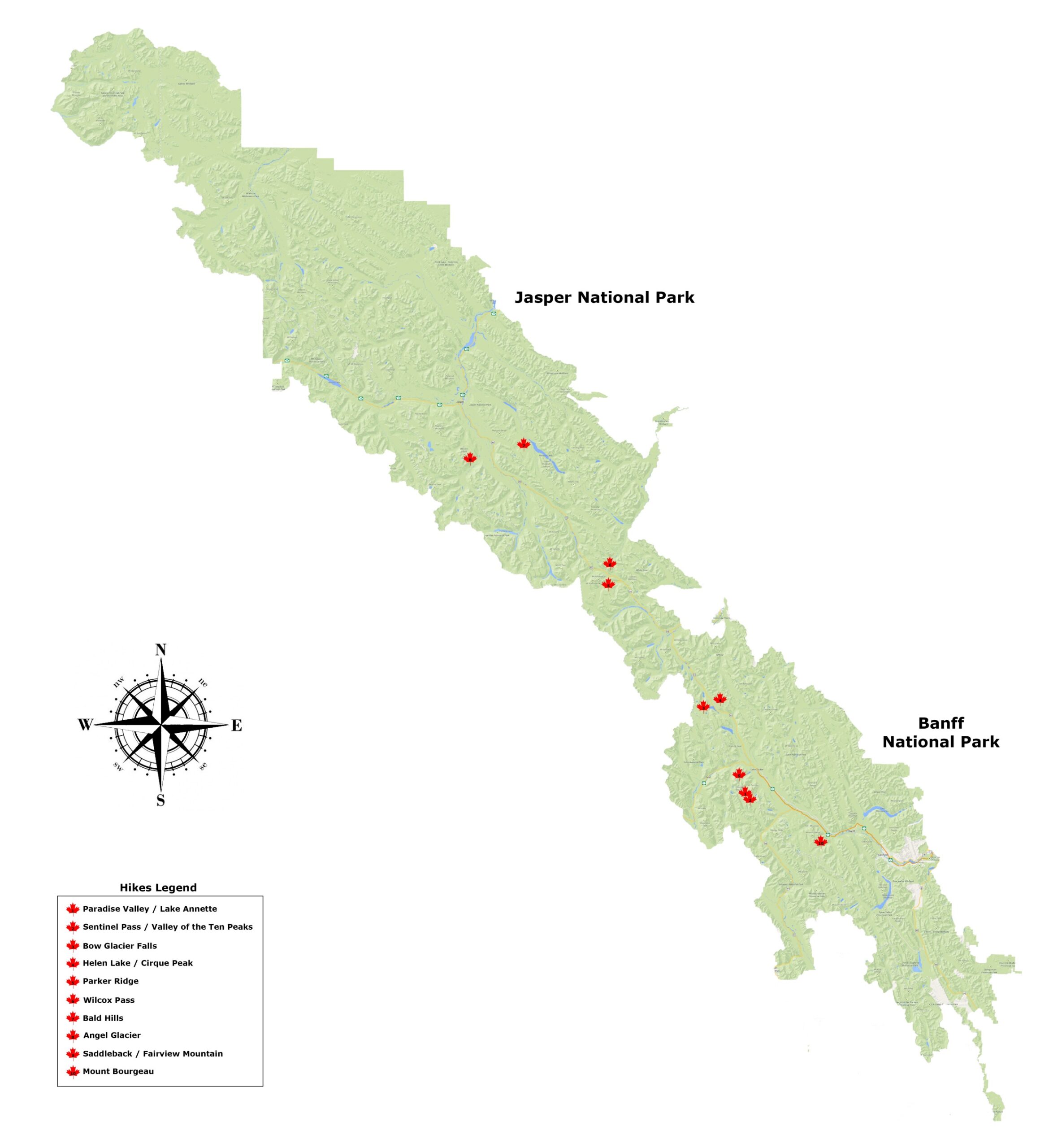
Similar to our journey through Banff NP, we were interested in doing some hiking in Jasper, though our time here was more limited. We managed to get in three shorter hikes (detailed below), totaling 16.5 miles and 4,450’ of elevation gain (bringing our overall total for our week in the Rockies to 67.7 miles and 20,188’ of elevation gain). One day in Jasper ended up being a total washout, eliminating one of our planned hikes. We had intended to do the Cavell Meadows/Angel Glacier Trail (a 5-mile hike around Mt. Edith Cavell), but it was just too wet. We did try, though – after driving to the trailhead in a steady drizzle, we started up the trail. Probably 30–40 minutes into the loop, though, it just got torrential, slippery, and unpleasant, so we turned around. We took one of the short turn-offs near the start of the trail so we could at least walk up to Angel Glacier, hanging precipitously on the north face of Mt. Edith Cavell, above the curious, green water of Cavell Pond.

En route to one of our hikes at Maligne Lake, we visited Medicine Lake, an exceptionally pretty lake if you are visiting in the summer months. Known as the “disappearing lake,” the 4-mile long azure pool is not a true lake, but rather is part of a karst, an underground drainage system formed from porous rock (in this case, limestone). During the summer, increased glacial melt water flowing from the Maligne River pours into the mudflat faster than the karst’s sinkholes can drain it, resulting in the temporary appearance of Medicine Lake. Some have compared this to a bathtub with a [partially clogged] drain, which I think is a clever analogy. As melt water (and consequently, the river’s flow) decreases in fall/winter, the sinkholes drain the water more rapidly than it accumulates, causing the lake to disappear and leaving only the exposed mudflat speckled with few small pools. Interestingly, scientists in the 1970s and 1980s added a nontoxic dye to Medicine Lake to map out the drainage network. The dye was detected (hours to days later) ~10 miles away in various lakes and springs throughout Maligne Canyon, as well as in Lac Beauvert, just outside the town of Jasper. Although its inaccessibility has precluded anyone from exploring it, experts believe that the Maligne Karst could be one of the most extensive underground cave structures in the world. The lake was pretty incredible to see as, driving around it, it is not small (really… 4 miles is long!). It’s mind-boggling to think that that much (albeit shallow) water just vanishes seasonally.


PARKER RIDGE
Distance: 2.5 miles
Elevation Gain: 925 feet
Rating: ![]()
![]()
A short, easy hike, we opted to check out Parker Ridge en route to Jasper National Park from the Lake Louise area of Banff NP. We wanted to dedicate most of the day to seeing some of the notable sights along the 3-hour, 150-mile drive up Canada’s renowned Icefields Parkway (waterfalls, scenic overlooks, etc.), so we decided to throw in a couple of shorter hikes along the way to break up the trip.
About midway between Lake Louise and the town of Jasper, the Parker Ridge trailhead is accessed from a small parking area directly off the Icefields Parkway. There really isn’t much to say about the hike, other than it’s a short walk up a small ridge. The trail has little elevation gain and limited scenery, the exception being the view of Saskatchewan Glacier (one toe of the Columbia Icefield) over the other side of the ridge. Unlike our other hikes, this route was packed with tourists looking for an easy ramble. If that is all you are looking for, or you just need to take a break from a long car ride up the parkway, Parker Ridge is probably a good choice. If you are seeking a more classic hiking experience, isolated in Alberta’s natural splendor, you should probably look elsewhere.


Pros – Easily accessible view of Saskatchewan Glacier, good for stretching driving legs with a short walk
Cons – Road noise, crowds, lackluster scenery, trail adjacent to the highway
WILCOX PASS
Distance: 5.0 miles
Elevation Gain: 1,100 feet
Rating: ![]()
![]()
About 4 miles north of Parker Ridge (and 2 miles south of the Columbia Icefields Centre) is the trailhead for Wilcox Pass. Another easy hike, the trail to Wilcox Pass gains only 1,100 feet in elevation over the 5-mile round-trip trek. The major highlight of this route is the sweeping view onto a portion (incredibly, only about 5%) of the Columbia Icefield, a spectacular piece of geological history.
A remnant of past ice ages, the sprawling Columbia Icefield is the largest ice mass south of the Arctic Circle, blanketing roughly 125 square miles and reaching astonishing depths of over 1,000 feet. Here, the thick, glacial ice has endured for thousands of years, and experts believe the area may have supported ice for more than two million years. The icefield’s last major advance was during the Great Glaciation, the largest modern ice age ~240,000 years ago (a period that lasted for ~100,000 years). The region’s extreme weather has facilitated the icefield’s continued existence, as it receives an average snowfall of 20–30 feet annually. Importantly, glacial meltwater feeds rivers that ultimately flow into three oceans, the Pacific, Atlantic, and Arctic, making the Columbia Icefield a hydrological hub of North America. Comprised of several distinct glaciers, including the prominent Athabasca, Saskatchewan, Columbia, and Dome glaciers, the Columbia Icefield’s ecological and geological significance make it a pretty fascinating place to stop and ponder Earth’s amazing history while enjoying the incredible, icy views that may not survive current global climate changes.
Beginning in an old-growth forest, the trail quickly climbs to an expansive alpine meadow, where the path rises and falls along rolling green hills, dotted with stunted alpine forget-me-nots and globe flowers. While the majority of the hike is through the barren, relatively flat meadowland, the trail culminates with an expansive view of the Columbia Icefield and surrounding peaks, some of the highest in the Canadian Rockies. Many visitors merely stop along the Icefields Parkway for a glimpse of the vast Columbia Icefield, but only a fraction of the Athabasca Glacier is visible from the road. Wilcox Pass provides a much grander, bird’s eye view of both Athabasca and Dome Glaciers, as well as Mt. Athabasca, Mt. Andromeda, Snow Dome and Mt. Kitchener.


Pros – Fabulous view of Columbia Icefield
Cons – Landscape is primarily forest and flat, alpine meadow
BALD HILLS
Distance: 9.0 miles
Elevation Gain: 2,425 feet
Rating: ![]()
![]()
![]()
![]()
Located in the southeastern portion of Jasper National Park, the Bald Hills comprise a scenic ridge overlooking Maligne Lake. For an easier hike, the Bald Hills trail offers surprisingly abundant scenery and great views of the surrounding mountain ranges. About an hour (30 miles) southeast of the town of Jasper, even the drive to the trailhead at Maligne Lake is tremendously scenic. Just off route 16, the 27-mile stretch of Maligne Lake Road winds through the mountains and around picturesque Medicine Lake, a nice spot to stop and visit during the summer months. Upon arriving at Maligne Lake, the trail is accessed across the street from the last parking lot at the end of the road.
The trail begins with a gradual ascent through a lush forest. Don’t forget insect repellent; we found it to be incredibly buggy at the start of the hike and were feverishly spraying ourselves with DEET as we walked. Not long into the hike the route splits in two directions – a steeper hiking route climbs to the left, while the fire road (longer and more gradual) wraps around the hillside. As a larger group just ahead of us took the hiking route, we decided to continue on the fire road for more seclusion and to check out the scenery. This branch of the trail was indeed tranquil, and we seemed to split off from all of the other hikers at the trailhead. Hugging the outer side of the hill, the trail peeked out onto the countryside and was warmed by the bright, morning sun. The trail eventually merged with the hiking route near an old hitching post in a small clearing considered a “lookout.” While this spot does offer satisfactory views of the vast Maligne Lake (14 miles long), continue to the Bald Hills summits for really exceptional panoramas.


From the hitching post, the trail dipped through a small meadowland speckled with wildflowers, including pink moss campion, delicate mountain heather, and glaucous gentian, a small, shimmering blue-green alpine blossom. The path then rose atop another hill before leveling off along the first section of the ridge.


After a flat walk, the trail climbed again to the summit of the first Bald Hill, giving way to fantastic, 360° panoramas. To the east and southeast, the majestic peaks of the Queen Elizabeth Ranges soared above Maligne Lake, with the glaciated summit of Maligne Mountain standing out from the neighboring bare, gray crests. To the west and southwest, the dark, serrated slopes of the Maligne Range plunged steeply to the intense, green valley below, carved by Evelyn Creek.


To prolong the hike and fabulous views, continue trekking along the treeless spine, as there are actually three Bald Hills summits along the ridge. As few people seemed to walk out beyond the first, we enjoyed this part of the hike in near solitude. A large cairn indicated the obvious end of the trail at the third summit, where the ridge dropped off abruptly. Standing atop the rocky outcropping that jutted over the edge of the Maligne Valley was dizzying, but the views could simply not be surpassed.


Pros – 360° panoramas of two mountain ranges & Maligne Lake, ‘bang for your buck’ scenery, beautiful alpine wildflowers
Cons – More popular route
Total distance – 16.5 miles (26.6 km)
Total elevation gain – 4,450 feet (1,356 m)
Total distance (Banff & Jasper) – 64.5 miles (103.8 km)
Total elevation gain (Banff & Jasper) – 18,688 feet (5,696 m)