Known for its thousands of crimson-colored rock spires, Bryce Canyon National Park is one of southern Utah’s most spectacular treasures. Contrary to its name, Bryce isn’t a single canyon, but rather a series of natural amphitheaters carved into the eastern side of the Paunsaugunt Plateau. With elevations between 8,000 to 9,000 feet along the rim, the slopes of the high plateau tumble more than 2,000 feet amongst an assortment of natural bridges, arches, rock windows, and fir forests, as well as the largest concentration of hoodoos in the world.
Bryce’s striking hoodoos are part of the Claron Formation – strata of pink and white limestone that formed between 35 and 55 million years ago when the region was part of a vast floodplain. The rock spires and other formations were sculpted from millions of years of erosion and weathering, with the area’s substantial temperature swings playing a central role in their creation. For more than 200 days each year, Bryce experiences temperatures that are both above and below freezing. Consequently, the repeated freeze-thaw cycles facilitate constant expansion and contraction of the rock and, along with ice and rain, are the primary sculptors of the whimsical silhouettes.
We decided to make a day trip to Bryce in mid-November, towards the end of shoulder season when the skies were clear, the temperatures cool, and the crowds significantly thinner than at the height of summer season. After an hour and a half drive from our place in Monroe, we spent most of the day on the trail – combining the Fairyland and Queen’s Garden/Navajo Loops for an 11-mile hike around the heart of the national park. We had enough daylight remaining to tack on the Bryce Canyon Scenic Drive, and ended up returning a few nights later to explore the hoodoos against the starry backdrop of the Milky Way. With a host of options for a one-day itinerary, read on to find out what we loved and what we wished we’d done differently.

Fairyland Loop
At the northern end of Bryce Amphitheater, Fairyland Loop winds for eight miles around towering hoodoos and unique rock formations, including landmarks such as the Chinese Wall and Tower Bridge. Passing through some absolutely spectacular scenery as we lost and regained 1,600 vertical feet, we loved every minute of this trail.
We began the hike near the North Campground Amphitheater. Alternatively, the trail can be started at Fairyland Point, however Fairyland Point Road closes seasonally (as it was when we visited). From the campground we headed north, choosing to hike the trail in a clockwise direction. For the first couple miles, the trail skirts the rim of the plateau at an elevation of around 8,000 feet. The views from here are sweeping, looking out on a vast expanse of soaring spires.


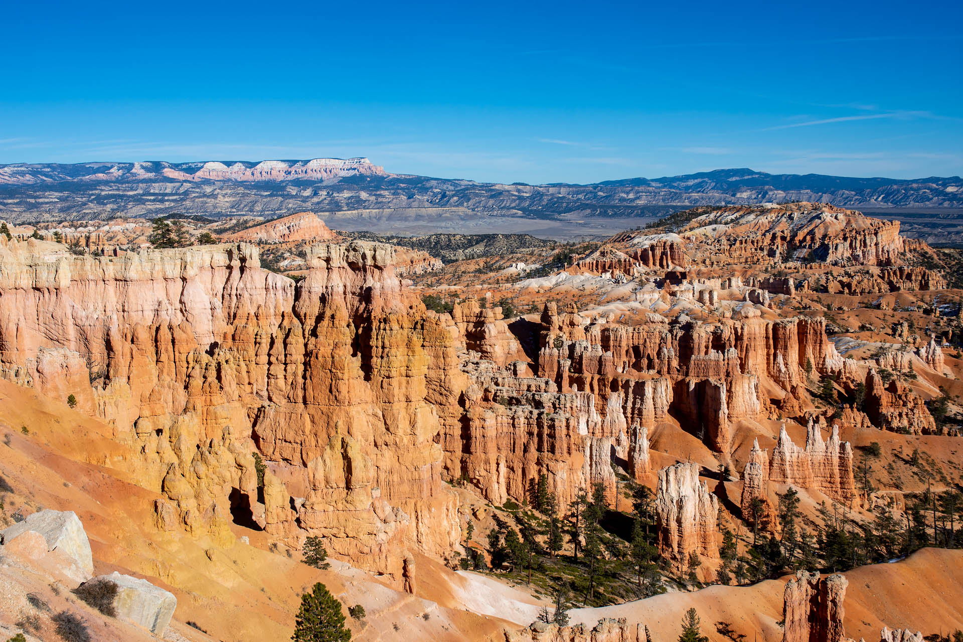
After reaching Fairyland Point, the trail drops quickly into the canyon, descending nearly nine hundred feet. As you lose elevation, the hoodoos (fairy chimneys) begin to rise around you, enveloping you from all sides as you traverse the dusty path. The sheer number of spires here is staggering, with layer upon layer of two-tone towers stretching indefinitely toward the horizon.


After about four miles, we reached the easternmost side of the trail. From here, we took in some striking views of the Sinking Ship – a distinct upwelling in the landscape that resembles the sharply-pitched bow of a sinking vessel. From here, we climbed a few hundred feet up a small hill to what came to be my favorite vantage point of the entire hike (see panorama below). The trail faded in the direction of a high mesa, giving way to a sea of hoodoos that stretched east toward the Sinking Ship. It was stunning.


As we rounded the next corner, we stumbled across a soaring pillar crowned with the silhouette of a lazing cat, presumably the feline gatekeeper of the southernmost section of trail. This final portion of the route was particularly scenic, curving beneath columns of blazing white limestone. The path then zigzagged back to the west, passing by the Tower Bridge and Chinese Wall before ultimately ascending back to the rim.


Being the longest of Bryce’s frontcountry routes, there’s expectedly less foot traffic than you’ll find on the national park’s shorter trails. For us, this is always a win. Aside from being sparsely trafficked, the scenery was just gorgeous and we couldn’t get enough of the views. If you’re looking to get away from the crowds for a solid outing amongst the hoodoos, we’d highly recommend this trail.
Total distance: 8.0 miles
Elevation gain: ~1,600 feet
Queen’s Garden / Navajo Loop
In stark contrast to Fairyland, we absolutely loathed this route. We probably should have suspected this would be the case, yet for some reason I still picked this trail. It’s short, it’s one of the park’s most popular paths, and it begins and ends at two of Bryce’s most visited viewpoints. Honestly, I don’t know what the hell I was thinking. Maybe I figured it was low season and it would be otherworldly pretty. Maybe I should just plead temporary insanity and move on. Regardless, for those of you yearning for a quiet hike without throngs of kids, larger groups, or the stray hiking pole being flung uncontrollably by those who have never hiked before, look elsewhere. Trust us.
The Queen’s Garden trail begins at Sunrise Point. After arriving here from Fairyland Loop via a quarter mile stretch of the Rim Trail, we should have just turned around and gone back. Sunrise Point was swarming with people – enough to piss me off under normal circumstances, let alone during a pandemic. However, we begrudgingly pushed on. The trail dipped down amongst an assortment of hoodoos, though it was nothing like the density we’d seen on Fairyland. As we descended down toward Peekaboo Canyon, the people were numerous and the views scarce.


After quickly reaching the junction at the bottom of the trail, we headed back up toward the rim via the Navajo Loop Trail toward Twin Bridges (the alternate route up the slot canyon of Wall Street was closed for the season). Surprisingly, the second half along Navajo Loop was much more bearable than Queen’s Garden. The crowds thinned quickly, and the trail became significantly more peaceful. That said, the hike still wasn’t worth the time. While the path’s iconic switchbacks are quite beautiful from above, there just wasn’t enough wow factor on this trail to nullify the crowds.


Once we arrived up at Sunset Point, we followed the Rim Trail for about a mile back to Sunrise Point, then continued north for another half mile to our initial starting point for the Fairyland Loop. After such a quiet, lovely morning, we were ultimately disappointed with our second trail selection. A lot of people seem to really enjoy this trail; however we were not two of them. If you’re looking for a shorter trail or have kids in tow, this route does offer the opportunity for a closer look at some of Bryce’s iconic spires. For us, though, it just didn’t fulfill our wants in a hiking trail.
Alternate route: This network of short loops also connects with the Wall Street trail. It would be possible to alternatively combine Queen’s Garden with Wall Street (similar in distance to Queen’s Garden + Navajo Loop) or Navajo Loop with Wall Street (beginning and ending at Sunset Point). That said, the trail would likely still be pretty heavily trafficked. We had originally considered pairing Navajo with Wall Street, however the latter closes during the winter months.
Total distance: 3.0 miles
Elevation gain: ~600 feet
Thoughts on trail choice
If we could choose again, we would definitely repeat Fairyland Loop. It was both wildly scenic and lightly trafficked. That said, we would undoubtedly skip the Queen’s Garden/Navajo Loop and instead try Peekaboo Canyon via the trailhead at Bryce Point. While Peekaboo Canyon is a more frequented trail than Fairyland, and can only be hiked clockwise, we have to imagine there would be less traffic than we encountered along Queen’s Garden. Considering I wouldn’t touch Queen’s Garden again with a fifty-foot pole (unless it was the middle of the night), the 5.5-mile Peekaboo Canyon loop would at least be worth a shot. Clocking in at around 13.5 miles and 3,200 feet of vertical gain, combining Fairyland Loop and Peekaboo Canyon would allow you to see the most in the heart of the park, and would be an easily-achievable day trip for those who hike regularly. I fully regret not making this decision at the time.
Combined hike (Fairyland + Queen’s Garden / Navajo Loops):
Total distance: 11.0 miles
Elevation gain: 2,134 feet


Bryce Canyon Scenic Drive
If you’re looking to explore the national park by car, the Bryce Canyon Scenic Drive (Hwy 63) stretches 21 miles point-to-point from its start at the intersection with Scenic Byway 12 to Rainbow Point, Bryce’s southernmost point. A number of viewpoints dot the route, offering varying perspectives of Bryce Amphitheater and the neighboring canyons. Additionally, many spots also offer access to the various frontcountry trails.
After a day of hiking, we had a bit of time left before sunset, so we figured we may as well check out the drive. There are more than a dozen signed viewpoints along Bryce Canyon’s scenic drive, however the four most photographed (running north to south) are Sunrise, Sunset, Inspiration, and Bryce Points. In addition to being accessible by vehicle along the scenic route, each of these overlooks can be reached via the Rim Trail – an 11-mile one-way footpath that parallels the paved road and edge of the plateau.

Of all the viewpoints we visited, I would argue that Bryce Point offers the most spectacular view in the park. The contrasting pink and white hues of the Claron Formation sediments are particularly apparent here, and the distant views of Grand Staircase-Escalante behind the tiers of hoodoos are stunning. While I would award second place to Inspiration Point, just two miles north, Bryce Point wins handily in my book. A favorite of many, Sunset Point offers views looking down onto Silent City – a maze of densely-packed hoodoos – to the south, as well as Thor’s Hammer to the north. It’s certainly pretty enough, though maybe a bit less dramatic than the other two overlooks.


Pro Tip: If you’re interested in photography along the scenic drive, plan to visit earlier in the day rather than later. The viewpoints are mostly east-facing, with the best shots of the hoodoos angled slightly north or south, rather than due east into the sun. If you drive the road later in the day, plan to arrive at the viewpoints at least 1.5 hours before sunset. If visiting in the fall or winter, plan to arrive more than two hours before sunset as the sun is much lower in the sky. To give an example, this shot of Thor’s Hammer was taken around 3:30pm from Sunset Point, a full two hours before sunset in mid-November. With the sun so low in the sky, the majority of the formation was already in shadow. Our biggest mistake was hitting both Bryce Point and Inspiration Point just before sunset (around 5:15pm and 5:30pm, respectively). While the views were amazing, this part of the amphitheater was entirely shaded. Definitely hit these viewpoints earlier in the day to take advantage of the hoodoos being bathed in full sunlight.

International Dark Sky Park
In addition to its hoodoos and hiking trails, Bryce is also renowned for its dark skies. The national park earned an International Dark Sky designation in 2019, joining a host of other certified spots in Utah that offer prime spots for stargazing. With that in mind, we ended up venturing back to Bryce a few days later to attempt some night sky photography on the eve of a new moon.
Torn between Bryce and Goblin Valley, we ultimately chose to check out Bryce’s night skies. Because we were traveling without camping gear, we drove over to the national park shortly before midnight, hoping to take advantage of the ultra-clear autumn skies. We started at Sunset Point, hoping to get some shots of Thor’s Hammer with the bands of the Milky Way. Unfortunately, the star bands were oriented such that we couldn’t capture them along with the iconic spire. While the photo ops here were less than perfect, walking down Navajo Loop in total darkness was kind of a cool experience. It was eerily silent, and the pitch-black hoodoos had a ghostly feel as they stood silhouetted by the glow of tens of thousands of stars.
We then moved over to Queen’s Garden, about a mile north. The hoodoos here better aligned with the star bands, though we still didn’t end up with any spectacular shots. Unfortunately, this was partially due to a fair amount of light pollution coming from Bryce Canyon City and the nearby campgrounds. We were honestly kind of surprised by this, as there are strict requirements on the acceptable levels of artificial light in certified dark sky preserves.


While it was beguiling to walk around Bryce’s hoodoos by starlight, we’d try Goblin Valley next time for some better photo opportunities. It’s much more remote, and with a wide valley to walk around rather than being confined to a narrow path with sheer drop-offs, we’d imagine there’d be a better chance of capturing the hoodoos against the Milky Way’s hazy core.
Know before you go
- Plan for variable weather. While summer temps are usually not too extreme (average is around 80°F in June, July and August), some days do approach or exceed 90°F and there’s very little shade on some of the trails to provide a lot of relief. Moreover, afternoon thunderstorms are common and lightning is quite dangerous at this time of year. Conversely, winter months are cold and quite snowy, and hiking at this time of year will likely require snowshoes. Additionally, nighttime temperatures fall below freezing for most of the year (October to May).
- For the photo enthusiasts: Almost all of the viewpoints in the national park are east-facing. The morning light should be beautiful, as you’ll mainly be shooting more to the north or south to capture the hoodoos. If you want to try to shoot during sunset, get to the viewpoints well before. The sun drops low enough a couple hours before sunset that all the hoodoos and amphitheaters quickly grow dark. We made the mistake of attempting late-day shots rather than early morning. Our rationale was that the sun being behind us, rather than in front of us or directly overhead, would offer some nice light. We failed to account for the sun falling too low behind the canyon’s rim, and for the fact that many of the best angles of the rock spires were actually slightly north or south, rather than directly east into the sun.
- We’d highly recommend visiting in the shoulder season. We visited in November and it was just perfect. There were significantly fewer visitors, the weather was cool and sunny, and the shuttle service had been suspended for winter (fewer vehicles and fewer people).
- For additional trail suggestions, check out the national park’s hiking page. Here, you’ll find Bryce’s frontcountry routes neatly organized by ability and distance.


