
One of Glacier National Park’s most iconic and popular hikes, the Highline Trail traverses 7.2 miles of scenic ridgeline from Logan Pass to the Granite Park Chalet. Skirting the western edge of the Continental Divide, the Highline is touted as ‘classic Glacier’ and sits atop many visitors’ hiking bucket lists. The trail climbed in priority on our to-do list with the COVID-associated closures within the east side of the park. With all of the trails in Many Glacier and Two Medicine inaccessible, we were forced to stick to trails around the Lake McDonald, Saint Mary, and North Fork/Goat Haunt areas.
As a one-way hike, the total route is just over 11 miles. The Highline Trail portion extends from Logan Pass west to Granite Park Chalet (~7.2 miles). To return to the Going-to-the-Sun Road at The Loop, it’s another 4 miles south from the chalet via the Loop Trail.
Alternatively, the trail could be hiked as an out-and-back from Logan Pass to Granite Park (the last four miles of Loop Trail are pretty lackluster). This return route would be about 15 miles total but with considerably more vertical gain (there is substantially more gain hiking west to east). Additionally, the Grinnell Glacier Overlook Trail is a short but steep 1-mile spur along the Highline about 0.5 miles from Granite Park Chalet. This optional side trail gains about 900 feet up to the overlook, so take this into account when planning your hike. Doing an out-and-back on the Highline including the overlook spur would make for a long, but doable, day on the trail if you’re comfortable with 17 miles and a fair bit of gain.

Trying to avoid peak trail hours, we decided to hike the Highline later on a weekday afternoon. We opted to hike the trail as a one-way from Logan Pass to the Loop, adding on the Grinnell Glacier Overlook Trail. Normally, the national park’s shuttle service makes thru hiking a breeze. However, with the shuttles closed due to COVID-19 (and only one vehicle), our only option was to try and hitch. We parked at The Loop, figuring that if we could get a ride up to the pass, we’d conveniently finish the hike back at the car, without having to worry about trying to hitch an evening ride and getting stuck.
Luckily, after snagging the penultimate parking spot at The Loop, we were picked up by the third car that drove by. I’m certain it was the wicked cute smiley face embellishing my otherwise pitiful sign. Our gracious drivers were a mother-daughter duo from Minnesota. Mom had been out visiting her daughter in Utah, and they were driving back to MN via the ‘scenic route’ through Glacier. We quickly jumped into the back of their white Crosstrek, along with the golden retriever’s plaid dog bed, and were on our way. [Aside: for those who are curious, pandemic safety guidelines were respected – all four vehicle passengers were masked and windows were rolled down.]

Though the NOAA forecast had predicted sunshine and wind, there was quite a bit of cloud cover up at Logan Pass (mountain weather for you). It was about 2 p.m. when we started out on the trail and, for the first couple miles, we passed a pretty solid number of hikers returning to Logan Pass. With some people opting to just hike a mile or so out on the trail, this particular section seems like it could get unbearably crowded on a peak-season weekend.
The first part of the trail roughly follows the contour of the Going-to-the-Sun Road, albeit a couple hundred feet higher. For about five miles of the hike, the trail hugs the western face of the Garden Wall, a steep ridge along the west side of the Continental Divide. Looking out from the ridgeline, Mt. Oberlin and the peaks of West Glacier dominate the landscape.


Perhaps even more exciting than the panoramic views, though, were the number of rodents we saw scurrying around the trail. Golden-mantled and Columbian ground squirrels darted through the desiccated grasses in search of the tastiest, end-of-season Indian Paintbrush blooms. From a pile of huge boulders, a lone pika alerted the neighborhood of the human passersby. At one point, a hoary marmot came scampering down the path in our direction, stopping at our feet to glance up curiously before continuing on his (or her) way.


For us, the highlight of the hike was unquestionably the spur up to Grinnell Glacier Overlook. The side trail was much less trafficked than the main Highline Trail, and the sharper climb gave way to even more impressive views of the surrounding peaks all the way out to the eastern end of Lake McDonald.

By the time we reached the highpoint it was after 5 p.m. With most other hikers well finished for the day, our only company was a pair of mountain goats – a doting mom and young kid. They poked around the rocks carefully for a few blades of grass, but were otherwise unimpressed by our presence.


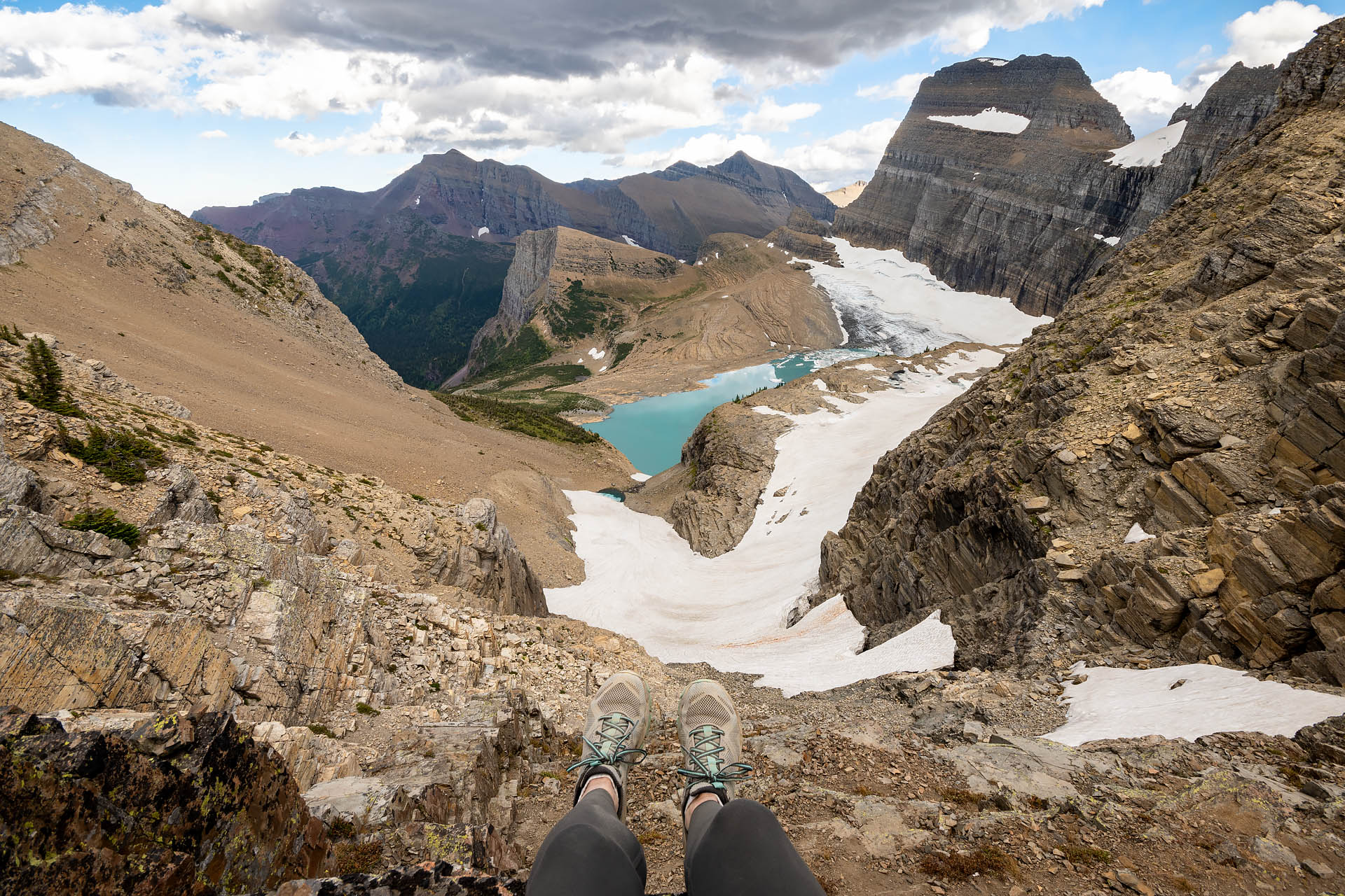
Peeking around the edge of the Garden Wall from the highpoint (~7,600’), a sheer edge drops down to Upper Grinnell Lake. At the head of the shocking aquamarine pool sits Grinnell Glacier, arguably the park’s most famed glacier. Sitting at around 7,000 feet on the north face of Mount Gould, the glacier is now just a fraction of the size it was when the park was created, having lost over 40% of its area since the mid-1960s1. Along the inside of the Garden Wall, Salamander Glacier hangs over the western shore of the lake. The view was absolutely breathtaking. It convinced me all that much more that we’d have to make a return trip to Glacier to hike the [closed] Grinnell Lake/Glacier Trail.

We were so taken with the views, goats, and solitude atop the overlook that we completely lost track of time. By the time we rejoined the Highline Trail it was nearly 6:30 p.m. With another half mile to Granite Park Chalet and another four miles to The Loop, we knew we’d be pushing daylight.
From Granite Park Chalet2, the last several miles to The Loop are completely underwhelming. The landscape transitions from forests to burn areas and scrub brush, and the views quickly vanish beyond the chalet. With time constraints and not much to look at, we were holding a solid 10:30 pace back to the road, pausing only a few times to yield to the large mule deer who were enjoying a twilight snack along the trail. We reached The Loop around 8:30 p.m., just in time to see the last light of day kiss the top of Heavens Peak.


Our thoughts: it was a good hike, if not slightly overhyped. While the views out to the west of the divide are imposing, the landscape isn’t particularly diverse… and the trail does lose points for sheer number of people. Grinnell Glacier Overlook, however, was nothing short of spectacular. In our opinion, it was not just the actual high point of the route, but also the visual pinnacle.

Total distance: 13.2 miles
Elevation gain: 2,580 feet


Notes:
1For an astonishing perspective on how much of Grinnell Glacier’s ice has receded, check out these comparison photos (1938 vs. 2016) from the USGS: https://www.usgs.gov/centers/norock/science/grinnell-glacier-1938-2016?qt-science_center_objects=0#qt-science_center_objects (photo credit: T.J. Hileman, GNP Archives & Dan Fagre, USGS).
2For the history buffs out there, the historic Granite Park Chalet is one of only two surviving chalets from Glacier’s original nine (Sperry Chalet is the other). Most of the nine backcountry shelters were built by The Great Northern Railway between 1910 and 1915. While a few were lost to natural causes – fire, avalanche, and deterioration (a few were built from wood, rather than stone) – the rest fell into disrepair following the WWII years.


