Lake O’Hara is indisputably one of the most stunningly beautiful spots in British Columbia’s Yoho National Park. Perched at an elevation of just over 2,000 meters (6,700’), the lake sits just west of the Continental Divide, on the other side of the Bow Range from Banff’s Paradise Valley and Lake Louise. The alpine wonderland surrounding Lake O’Hara is peppered with a number of other jewel-tone lakes and blanketed with larch forests – all encircled by the massive peaks of Mt. Huber, Yukness, Hungabee, Biddle, Park, Owen and Odaray.


Unlike other areas of Yoho and Banff National Parks, Parks Canada strictly limits visitor access around Lake O’Hara. The restrictions may seem inconvenient, but they are super important to preserve this unique alpine environment, and also to ensure the area doesn’t see the unbearable and unsustainable overcrowding that has come to devastate places like nearby Lake Louise and Moraine Lake in recent years. Consequently, you have exactly two options if you’d like to visit Lake O’Hara: (1) win a highly sought-after day-use shuttle ticket or overnight reservation, or (2) arrive on foot, which means being physically capable of hiking 30+ kilometers in a single day.
When I told Stephan months ago that we’d have to walk 6.5 miles to access a trailhead then walk another 6.5 miles back out after our hike, he looked at me like I had three heads. Dumbfounded by my seemingly senseless proposal, he laughed and told me there was zero chance. I was slightly miffed, but completely undeterred. After eighteen years together, I’d become a seasoned player at this game. With enough persistence, there was always a chance. Sure enough, after only a moderate amount of persuasion, he was onboard for the road walk.
After much anticipation, we finally made it up to Lake O’Hara the second Friday in September. We’d been trying to plan a visit ever since the last trace of snow melted off the All Soul’s route at the end of July. However, we ended up delaying at least a half dozen times in six weeks for one reason or another – dodgy weather, smoke-filled skies, and even an unforeseen, 36-hour highway closure. We figured if we were going through the effort of the dreaded Lake O’Hara road walk, we wanted conditions to be as ideal as possible. Finally, after more than a month, perfect weather and air quality forecasts aligned with a day that Stephan could take off from work. Crossing our fingers that this was finally going to happen, we packed up our gear filled with excitement to finally hit the trail.

Getting there
The Lake O’Hara Parking Lot is just off the Trans-Canada Highway, about 15 km east of Field and 15 km west of Lake Louise Village. To access Lake O’Hara and the surrounding trails, you have two options: (1) score a coveted and highly competitive shuttle ticket, or (2) hoof it 13 miles (22 km) roundtrip up the Lake O’Hara Fire Road. Cycling on the service road is prohibited, and park rangers patrol the length of road constantly.


Parks Canada shuttle
If you’re hoping to day trip to Lake O’Hara, the Parks Canada shuttle is the most convenient option. However, it’s also the most competitive. We talked with several people who had waited years before scoring a ticket.
Each spring (typically March), Parks Canada holds a lottery for that calendar year’s summer season (June to October). Each lottery submission costs $10 CAD (non-refundable), and allows the applicant to select up to six dates/time slots for a group of up to six people. Tickets are extremely limited, with only around 30 slots available daily for day hikers (the other spots are reserved for campers). There are two inbound shuttles a day – one at 8:30 a.m., the other at 10:30 a.m. Outbound shuttles are at 9:30; 11:30; 14:30; 16:30; 18:30.
If you’re lucky enough to nab a ticket, roundtrip costs (CAD) for 2022 were $14.70 for adults, $7.30 for youth, and free for 5 and under (sitting on laps). There’s an additional non-refundable reservation fee of $4.50/ticket.
If you’ve hiked in for the day on foot and are hoping to snag a seat on one of the outbound afternoon shuttles, outgoing bus fare is $9.75 for adults and $4.75 for youth (again, children 5 and under are free on laps). Drivers only accept cash (bring exact change), and there is no guarantee you’ll get a spot. Those with reservations get priority, so be fully prepared to hike back out at the end of the day.
Lake O’Hara road walk
If you aren’t one of the lucky few with a shuttle ticket or lodge reservation, the only access to Lake O’Hara is via the 11-kilometer service road. The road isn’t particularly steep, though it gains around 500 vertical meters (1,500’) to the lakeshore.
While there is a chance you could nab a seat on an outbound shuttle at the end of the day (pending availability), you should expect to walk both in and out. This means that whatever hike you plan to do around the lake will have an additional 22 kilometers (13 miles) and (500 meters) 1,500 feet of elevation gain tacked on with the roundtrip road walk.
When you get to the road, you’ll find park rangers on site to advise you about what you are getting into. Average hikers/walkers should expect to spend between 2 to 4 hours each way walking the road. We are pretty fast hikers, and it took us 1 hour 45 minutes each way averaging a 3.5 mph (5.6 kph) pace.
Trails around Lake O’Hara
Once you’ve reached the lake, you’ll find a whole host of trails to explore. In addition to its famed Alpine Circuit – one of the more difficult maintained trails you’ll find around the lake – Lake O’Hara boasts a number of other easy and moderate trails:
There are also five alpine routes at Lake O’Hara. The first three link together to form the 8-mile (13-kilometer) Alpine Circuit:
Because of the terrain and elevation gain, the five alpine routes are considered the more demanding trails in the area. If you hike regularly in the mountains, you shouldn’t find any major difficulties. For new hikers who may not be used to hiking over boulders or are not super comfortable with heights, some of the alpine sections may be challenging.
As experienced hikers who regularly hike 30 to 40 km a day, we found the trail to be only moderate in difficulty. Additionally, all alpine routes are very well-marked, with blue and yellow blazes both frequent and conspicuous. While the symbols do appear regularly, it’s best to have a GPS map downloaded offline before you go. Some areas have several intersecting trails (especially around the Opabin Plateau), so you do want to be prepared for some minor route-finding (AllTrails and Gaia maps are two good options).


Detailed trail descriptions, as well as links to closures and trail conditions, can be found on the Parks Canada website. Always check trail conditions before heading out.
Hiking the Alpine Circuit
The full alpine circuit (Wiwaxy to All Soul’s) is an 8-mile (13-km) loop. However, there are multiple trails that access the alpine region. If there’s a particular section you’d like to skip, either to shorten the hike or avoid a steeper or more exposed section, it’s possible to tailor the loop. Both the Wiwaxy Gap/Huber Ledges or All Soul’s sections – the two steepest and most exposed – can be easily bypassed.
We chose to hike the full alpine circuit in a clockwise direction. We climbed up to Wiwaxy Gap, traversed the Huber Ledges and descended down to Lake Oesa, followed the Yukness Ledges to the Opabin Plateau, checked out Obapin Prospect, then closed out the loop by taking the All Soul’s Traverse down to Schaffer Lake and the Elizabeth Parker Hut.
It seems that most people prefer to hike in this direction. While some do hike counterclockwise, it seems those individuals are in the vast minority. Most hikers have said they’d rather go up than down the Wiwaxy portion of the trail, as you do have to do some light scrambling up a few rocks.
Having completed the route, I would personally feel comfortable hiking in either direction; however Stephan said he would prefer to do it again clockwise. While I thought Wiwaxy and All Soul’s seemed about equivalent in steepness, my Garmin suggested that Wiwaxy was indeed slightly steeper. For those curious, it’s about 1,600 vertical feet over 1.1 miles up the steepest portion of Wiwaxy versus 900 vertical feet over 0.8 miles up the steepest section of All Soul’s.
Wiwaxy Gap & Huber Ledges
After a fairly unexciting walk up the access road, Stephan and I were pumped when the Lake O’Hara Campground came into sight. Really, the haul up the road wasn’t as bad as we expected. It was peaceful and – save for one inbound shuttle, one outbound, and a couple of park trucks patrolling the road – there was no vehicular traffic. While the trip was quick and easy enough with fresh legs and that early morning energy, it’s still just a road; we were anxious to get on a real hiking trail.


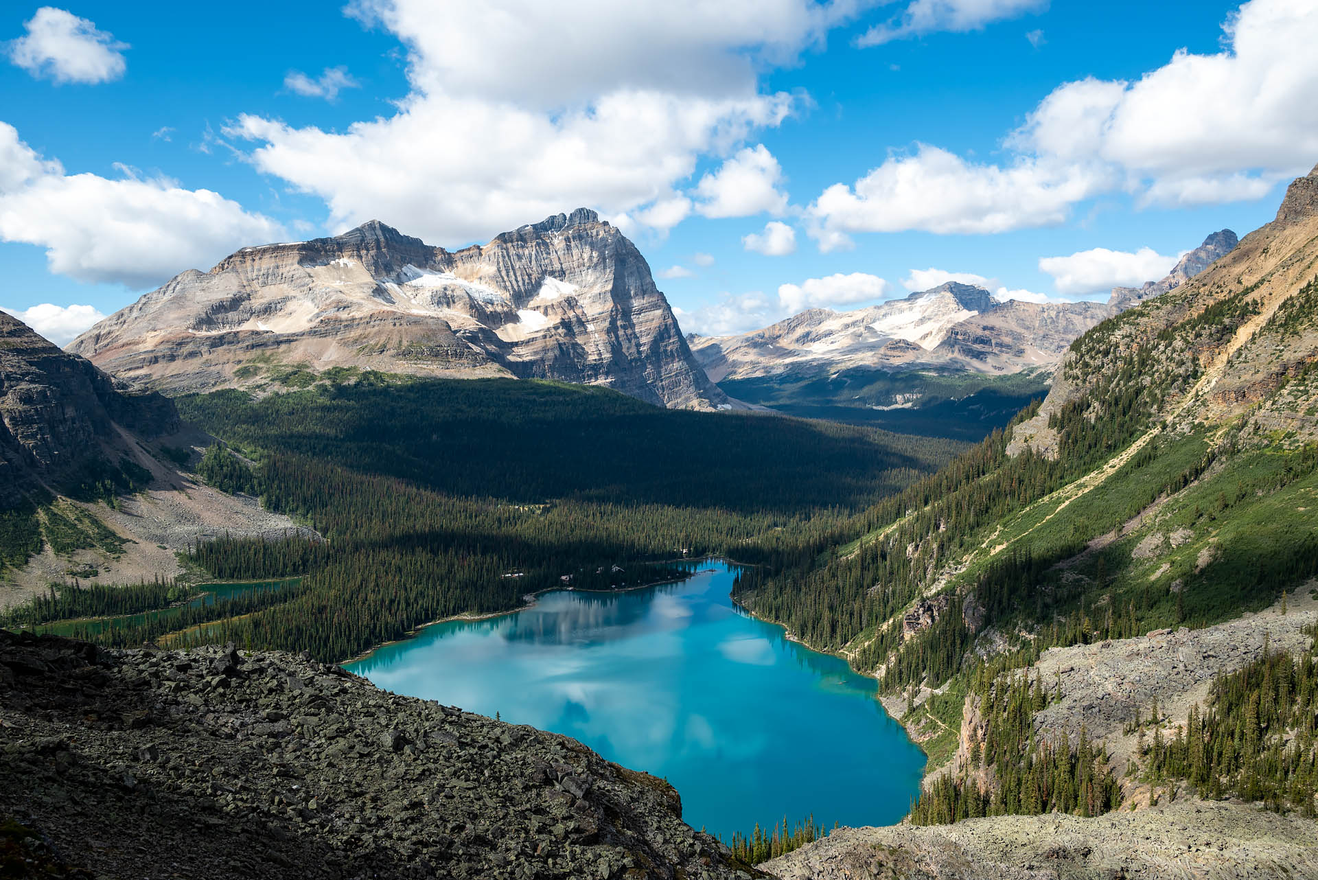
From the campground, we made our way along the hook-shaped cove on the northwestern side of Lake O’Hara and began climbing immediately through the forest. Within just twenty minutes, we’d cleared the tree line and gained the open ridge. It certainly didn’t take long for some amazing views to open up. As soon as the trees gave way, we were met with a sweeping view of Lake O’Hara’s sapphire waters with Mounts Schaffer and Odaray rising behind.


After a short but moderately steep ascent, we reached Wiwaxy Gap – the col between Mt. Huber and the Wiwaxy Peaks. At around 8,400 feet (2,560 m) in elevation, this spot is the highest point along the alpine circuit. To the north of the pass, we gazed back at the valley of our long approach, with the Cathedral Formation rising in the distance. Looking down the south side of the pass, Mt. Yukness’ sharp but stunted summit rose above Yukness Lake and Lake O’Hara. Beyond that, the enormous peaks of Ringrose, Mt. Hungabee and Mt. Biddle were looking especially epic with the fresh dusting of snow that fell overnight.


From the col, the trail descends fairly moderately along the Huber Ledges. This narrow stretch of trail wraps around the southwest side of Mt. Huber for about half a mile (0.8 km) as it makes its way toward Lake Oesa. If you’re new to hiking and aren’t used to heights and edges, you may not love this section of trail (you may even want to skip it if you’re feeling unsure). The exposure here is pretty mild by alpine hiking standards, but it could feel intimidating to a new hiker or those with a fear of heights. There are a few spots along the ledges that are pretty narrow.


As we made our way along the ledges, we were lucky to spot a handful of mountain goats grazing indifferently up on the rock bands. Pausing to look back, the views of Mt. Schaffer, Odaray and Wiwaxy were pretty spectacular through here.


Lake Oesa & Yukness Ledges
After descending a distance of 1.2 miles (1.9 km) from Wiwaxy Gap, the trail reaches the western shore of Lake Oesa. Pronounced oh-EE-suh and meaning ‘ice’ in Stoney language, the brilliant blue waters of Lake Oesa are nestled beneath the serrated summits of Mt. Victoria, Lefroy, Glacier, and Ringrose.


It was about four hours into our day with the clock hitting noon as we arrived at the lake, making it the perfect spot to pause for lunch. We were pretty surprised to find just one other pair of hikers enjoying the serenity of the lake at lunchtime. Even with such limited access to the area, we had expected to see far more people here.
From Lake Oesa, the trail heads south along the Yukness Ledges. For those with an aversion to heights, this section of trail is much wider than the Huber Ledges and has virtually no exposure. There is a short stretch of rocks and boulders to navigate between the lake and ledges, so those with less experience may find the terrain here to be slightly more difficult than other sections of the route.


While the entire circuit is astonishingly scenic, the Yukness Ledges were a favorite spot. The panorama of Lake O’Hara here is sweeping, with Yukness Lake and neighboring Mary Lake just coming into view. Beyond Lake O’Hara, the peaks of Odaray, Mt. Stephen, Cathedral Mountain, and the Wiwaxy Peaks look exceptional grand. Additionally, because the views here are northwest facing, the afternoon light is absolutely gorgeous on the landscape.


Opabin Plateau
Finally able to tear ourselves away from the views along the Yukness Ledges, we continued making our way south toward the Opabin Plateau Trail. Translating to ‘rocky’ in Stoney language and peppered with alpine tarns, the Opabin (oh-PAY-bin) Plateau is another highlight of the alpine circuit.
Our only misstep of the day was taking a slightly earlier right-hand turn than we’d initially planned. This caused us to inadvertently cut off Opabin Lake and instead pass alongside Hungabee Lake. We just kind of shrugged and figured it gave us an excuse to return. From Hungabee Lake, we then passed between Moor Lakes and the Cascade Lakes via the Opabin Highline Trail as we headed toward Opabin Prospect.


Like the vista from the Yukness Ledges, the view from Opabin Prospect is pretty unreal. Sitting slightly southwest of the Yukness Ledges, Opabin offers a similar view of Lake O’Hara and the surrounding peaks, though now with a panoramic look at Mary Lake. Again, we expected that viewpoint to be at least somewhat brimming with people. However there was just one solo hiker up there enjoying the perfect September afternoon. We were stunned.


All Soul’s Prospect
From Opabin Prospect, we continued southwest along the All Soul’s Traverse to close out the loop. This is the last climb of the route, with the trail gaining around 900 vertical feet in about 0.8 miles to the highpoint atop All Soul’s Prospect.


Like the rest of the route, the views here equally incredible. As you gain elevation, you can make out the flat bench of the Opabin Plateau rising above Mary Lake. Beyond Lake O’Hara’s hooked shoreline, the Wiwaxy Peaks appear dwarfed by neighboring Mounts Huber, Victoria and Lefroy. Looking closely, we could make out the faint path we’d followed earlier that morning up to Wiwaxy Gap.


While the views to our right (north) had us totally captivated, we couldn’t help turning around intermittently to enjoy the views back toward the east. With the sun much less harsh than it was earlier the day, we were now able to get a great look at Ringrose and Hungabee rising over Hungbee Lake and the Opabin Plateau.


In short order, we reached the ‘summit’ of All Soul’s Prospect. At an elevation of around 8,100 feet (2,470 m), the cairn here marks the second highest spot along the alpine circuit. From the top, we were able to look out over Schaffer Lake and Mt. Odaray – the last mountain view we had before dropping back down toward Lake O’Hara. After eight miles (13 km) of some of the most beautiful scenery we’d ever seen, it was hard to accept that we were finally going to have to surrender these views.


Alpine Meadow
After descending from All Soul’s Prospect, we joined up with the Alpine Meadow Trail at Schaffer Lake. From here, it was a quick and moderate descent to the Elizabeth Parker Hut, one of about thirty backcountry shelters run by the ACC (Alpine Club of Canada). This historic log cabin was built in 1919 and named after one of the founding members of the ACC. Sitting just 500 meters from Lake O’Hara, the popular hut sleeps around twenty people (depending on season) and reservations fill up extremely quickly.
From the Elizabeth Parker Hut, we continued through the meadows for the final half-kilometer stretch of trail, ultimately meeting back up with the road beside Le Relais Day Shelter. The small chalet is run by the Lake O’Hara Trails Club and offers trail guidance as well as an assortment of light snacks and beverages. Before we left home that morning, Stephan shoved a few bucks into his pack, hoping he and Sanchez could score a piece of Le Relais’ world-famous carrot cake at the end of our hike. While we read the cake typically sells out by noon, he managed to fortuitously get his hands on a generous slab when we arrived at the shelter at 4 p.m. It was yet one more shocker to cap off one hell of a day. Aside from Stephan’s obvious excitement at finding cake at our 15-mile (24-km) mark, Sanchez was totally floored that her hike culminated at a snack shack.


While the morning hike up the service road was filled with anticipation and vigor, I can’t say the same for the return. While we still had plenty of energy, walking 6.5 miles down a road at the end of a hike is just not that fun. The highlight of our final slog ended up being a family of grouse, whose curious and outgoing temperament kept us engaged about a mile from the parking lot.


Although we had to endure thirteen miles of tedious service road, the extra distance and mild boredom was undoubtedly worth being able to spend a day exploring such a special place. With the most crystal-clear skies and perfect temperatures – plus the unexpected piece of cake at the end – it was so much more than we could have asked for. Someone was even taken enough with Lake O’Hara’s awe-inspiring landscape that he swiftly admitted he’d be willing to walk that road again for a return visit.


Total distance: 21.8 miles (35 km)
Elevation gain: 4,986 feet (1,520 m)


Know before you go
- Pets: Leashed dogs are welcome on all trails around Lake O’Hara, however they are not allowed on shuttles or in any building. Consequently, if you want to bring you furry friend, you’ll be walking the road both in and out. Make sure your dog is comfortable covering a distance of at least 30 km.
- Snow: Because this is an alpine route, snow can linger on trails well into summer and can reappear before the start of fall. The All Soul’s Traverse in particular (largely shaded) can hold snow well into July. Additionally, some sections of trail are quite narrow and can be pretty precarious in slick conditions (e.g. Huber Ledges, All Soul’s). This summer, it was the end of July before the entire circuit was snow-free.
- Weather: As mentioned above, this is a high-elevation route. Be sure to wear and pack layers and be prepared for all conditions. Another thing to keep in mind is that large sections of the trail have no shade. Make sure to bring proper sun protection.
- Trail conditions: Always check trail conditions and closures on the Parks Canada website before heading out. The park system regularly updates important information such as snow conditions, trail restrictions, seasonal closures, potential hazards (e.g. deadfall, creek crossings), and bear advisories.
- Water: Make sure to carry plenty of drinking water. If you run out, potable water is available at the Lake O’Hara Campground.
- Bear spray: As with any other trail you’re hiking around the Canadian Rockies, make sure to carry bear spray with you. Grizzlies are known to frequent the Lake O’Hara Fire Road as well as the trails around the lake.
- Restrooms: Bathroom facilities are available at the campground and beside the Elizabeth Parker Hut. There are also restrooms at the Lake O’Hara Parking Lot, so you have the opportunity to use the facilities before walking the road or boarding the shuttle.
- Cash: Cash is the only form of payment accepted by Le Relais Day Shelter. All proceeds from Le Relais go to the Lake O’Hara Trails Club, a non-profit group that works very hard to maintain Lake O’Hara’s impeccable network of trails. Additionally, if you intend to try for a stand-by spot on either the inbound or return shuttle, you will need to pay in cash. Bring the exact amount as they don’t give change.
- Planning your trip: For detailed information on shuttles, camping, schedules, timetables, and reservations, check out Lake O’Hara’s trip planning page.
- Day use reservations: Because of Lake O’Hara’s popularity, Yoho National Park strictly limits visitors to preserve this special area. Consequently, shuttle tickets are only available via a random draw. Day hikers can typically apply for shuttle tickets in March for summer season dates (June to October). Applications can be made on the Parks Canada Reservation Service (PCRS) webpage, or by phone (1.877.737.3783).
- Camping reservations: Reservations for campsites are available on a first-come first-served basis and typically open in early February for summer months (June – October). Again, super limited and you can apply by phone or online.
- Leave no trace: This area is incredibly special and should be treated as such. Hike respectfully, stay on designated trails to protect fragile alpine vegetation, and pack out all waste… all of it. The same rules apply for your furry friends. Keep them leashed at all times to protect wildlife and vegetation (and for their own safety), and clean up and carry out any and all waste.


