If you’re staying in Durango for a while and looking to get outside a bit closer to the city, there are a number of great trail options for both hiking and biking. While we spent every weekend exploring the stunning San Juan Mountains during our month-long stay, these short trails in/near Durango were perfect for post-work outings during the week. Importantly, all trails on this list are dog-friendly and Sanchez-approved.
Animas City Mountain
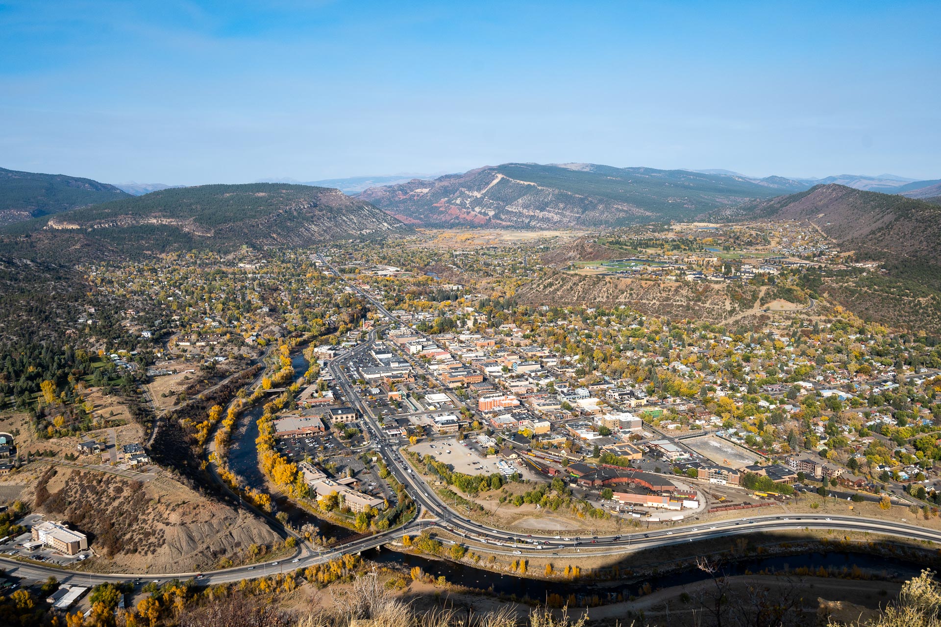
Arguably the most well-known and most frequented trail within Durango is Animas City Mountain. The trail is a six-mile loop that climbs from the west side of the city to an elevation of ~8,180 feet, offering sweeping views of the Animas River Valley and downtown Durango. If you want to poke around a bit, there are also several short side trails that all link back up with the main loop. The well-worn single-track can be used for running/hiking or mountain biking, and it’s also dog friendly. While it was never overly crowded when we were there, it was definitely the most trafficked city trail we used (save for the paved Animas River Trail).


Getting there: The Animas Mountain East Trailhead is just 2 miles north of downtown off W 4th Ave.
Total distance: 5.7 miles
Elevation gain: 1,624 feet


Perins Peak
Standing at an elevation of ~8,330 feet, Perins Peak is Durango’s most prominent summit. The trail to the top is similar in both length and vertical gain to that on Animas City Mountain, however the route is much more lightly trafficked. This is, in part, due to the fact that the area serves as a wildlife refuge and the trail is actually closed for the majority of the year. Additionally, this trail is only open to hikers; no mountain bikes or ATVs are permitted. Again, the trail is dog friendly, but your furry friends must be leashed here.


A six-mile out-and-back trail leads from a small trailhead northwest of downtown to the precipitous, rocky ledges that crown Perins. For the first mile, the trail is surprisingly flat, winding through a quiet forest. The trail then begins to climb gently, steepening only for the final mile or so to the summit. The views from the top are quite lovely – looking over to neighboring North Perins Peak and out to the La Plata Mountains, across downtown Durango and down on Hogsback, and south to Lake Nighthorse, a large reservoir that provides water for tribal members along the Animas River. Picturesque and serene, this was our (and Sanchez’s) favorite spot in Durango.

It’s important to note that this trail is actually closed for two-thirds of the year (December 1 to July 31). If you want to explore Perins Peak, you’ll have to visit during the months of August to November. The Perins Peak State Wildlife Area is closed in the spring/summer months for peregrine falcon nesting, and serves as a winter refuge for deer and elk populations.
Getting there: The trailhead is about 3 miles (10 minutes) northwest of downtown Durango in the Rockridge neighborhood. Traveling north on Main Ave, take a left onto W 25th Ave and another left onto Clovis Dr. Follow Rockridge (or Tanglewood) Drive to a small, dirt parking area at the end (intersection) of the two streets.
Total distance: 5.7 miles
Elevation gain: 1,751 feet


Hogsback Mountain
Hogsback Mountain is one of Durango’s most recognizable features – a long, serrated ridge rising 900 feet above the west side of downtown. Hogsback’s crest can be reached via a series of trails that make up the Overend Mountain Trail System. This crisscrossing network of more than a dozen trails covers some 300 acres and is a prime spot for mountain biking and trail running.
To get to Hogsback’s ridge, we followed the Brown’s Ridge Trail to the Hogsback Trail – seemingly the most direct route, which gains just over 700 vertical feet in its one-mile ascent. While the trail is not difficult, there’s quite a bit of loose dirt and some spots have some pretty decent exposure as they skirt the edge of the saw-toothed ridge.
If you’re looking to get views of the city from its most iconic peak, Hogsback makes for a nice, quick afternoon walk. That said, it seems like the dusty, single-track trails of the Overend Mountain System are perhaps best suited for mountain biking. With jumps and berms, the trails seem to be the perfect playground for local riders.


Getting there: Overend Mountain Park’s Hidden Valley Trailhead is just 2 miles (less than 10 minutes) northwest of downtown. You can get there by taking either N Main and 22nd Street to Arroyo Drive, then taking a left on to Hidden Valley Circle, or by taking Forest Ave up to Arroyo Drive and Hidden Valley Circle. Parking is limited to a few cars at the end of a small cul-de-sac. Alternatively, there are two other trailheads – the Crestview Street Trailhead and Leyden Street Trailhead.
Total distance: 2.0 miles
Elevation gain: 766 feet


Smelter Mountain
Just south of Hogsback, Smelter Mountain stands at just over 7,700’ tall, rising roughly 1,200 feet above the city of Durango. From the trailhead, an out-and-back trail leads up the rocky hillside, gaining just over 1,000 vertical feet in one mile. From the viewpoint, you get a surprisingly lovely vista of downtown, with notable landmarks including the Durango Silverton Narrow Gauge Railroad Station & Museum and the twisting Animas River.
After you reach the overlook the trail continues west, following a dusty service road (Rd 212) to a series of radio towers. Smelter’s official summit on various maps looks to be near the radio towers, though you don’t gain anything in views by continuing on for the extra mile. The trail (now service road) rises and falls along the ridge before descending down the back side of the mountain. If you’re looking for a quick, post-work trail run/walk, the first 1.2 miles up to the overlook give you a nice workout and view.


Be aware: If hiking with pups, there are a lot of prickly pear cacti along the first half of this trail. If your dog likes to snuffle around at the edge of the trail like Sanchez, pay extra attention so he/she doesn’t get stuck.
Getting there: The trailhead for Smelter Mountain is just 2 miles (6 minutes) south of Durango on Smelter Place. Follow Camino del Rio out of town, then take a left onto Frontage Road (across from Nature’s Oasis). Take a quick right onto County Road 210, and then a right onto Smelter Place.
Total distance: 4.2 miles
Elevation gain: 1,458 feet


Purgatory Flats
This one’s a bit outside the city, but worth mentioning if you’re staying in the area. About 25 miles north of Durango is the Purgatory Resort, one of Colorado’s premier ski destinations. Just across the highway, you’ll find the Purgatory Trail – a moderately trafficked, four-mile (one-way) trail that dips down to Purgatory Flats and follows Cascade Creek south to its confluence with the Animas River. We were staying just north of Durango’s downtown, right off Highway 550, so Purgatory was about a 20-minute drive for us. If you’re staying somewhere downtown, it’ll be closer to a half hour by car.
From the trailhead, the Purgatory Trail (#511) descends about 800 vertical feet over one mile to the flats. The trail then follows the contour of Cascade Creek for another three miles to its junction with the Animas River and Animas River Trail (#675).1 The flats offer some lovely views of the surrounding peaks, including the 11,871’ summit of Potato Hill (Spud Mountain) and the West Needle Mountains. Sanchez particularly enjoyed chasing rocks in Cascade Creek. In fact, she had so much fun splashing in the creek and reveling in some off-leash running time that we only ended up completing about half the trail (note: if you hike the full-length as an out-and-back, the trail clocks in at 8 miles).


1 Heads up: This trail is distinct from the paved, multi-use greenway in Durango of the same name (see description below). Trail #675 is a 5.5-mile, one-way trail that links Purgatory Flats with the Needle Creek Trail (#504), a route that goes east to Chicago Basin (https://www.fs.usda.gov/recarea/sanjuan/recreation/hiking/recarea/?recid=42738&actid=50).
Getting there: Follow N Main and US-550 N out of Durango and continue north for about 25 miles. Take a right onto Tacoma Drive, across from the Purgatory Resort. After about a quarter mile, a pond and small parking area will be on the left. The Purgatory Trail is on the right just across from the lake.
Total distance: 3.4 miles
Elevation gain: 735 feet


Animas River Trail
Running roughly eight miles from Dallabetta Park – near an industrial area south of downtown – north to Oxbow Park and Preserve, the Animas River Trail is an integral part of Durango’s community. The paved, multi-use greenway runs through the heart of Durango, crossing a handful of bridges and connecting neighborhoods and parks with schools, rec centers, and the public library as it skirts the banks of the tree-lined Animas River.
When we visited in October (2020), the city had just finished construction on Oxbow Park. Additionally, construction was wrapping up on the final mile of trail that connected the new greenspace with the trail’s former northern terminus at 32nd Street. Our condo was just a mile from the Oxbow Preserve, so we frequented this northern stretch of the Animas River Trail for afternoon walks with Sanchez. While it’s expectedly more heavily used than the neighboring mountain trails, it’s a really pretty little greenway.


Final thoughts
One of our favorite things about Durango was all of these nearby trails. We just loved being able to get outside for a couple hours after work for a short hike with Sanchez. Better yet, because most of the trails are just a few minutes from downtown, we could pop over to Cream Bean Berry for a post-hike ice cream, or grab a quick dinner for carry-out at one of our favorite local restaurants. If you’re hanging out in Durango for a while, go out and enjoy some of these trails… you won’t be disappointed.


