Tucked away on the outskirts of Canyonlands National Park and Labyrinth Canyon Wilderness, Horseshoe Canyon is a remote gem rife with Native American history and scenic beauty. Covering a huge swath of southeastern Utah’s high desert, Canyonlands is a maze of canyons and buttes carved by the powerful forces of the Green and Colorado Rivers. This rugged region has been occupied for more than 10,000 years, and the canyons hold a lot of ancient stories and secrets within their walls.
One of the many canyons within the national park is Horseshoe Canyon. Horseshoe Canyon has been home to indigenous groups for millennia, with the oldest Paleoindian artifacts dating to between 9000 and 7000 BCE. Native cultures continued to occupy the area until around 1300 CE. The canyon was home to nomadic hunter-gatherers followed by agrarian societies. In later centuries, the Fremont and ancestral Puebloan cultures inhabited the canyon, though they ultimately abandoned the area by the 14th century. European settlers didn’t move into the area until the early 19th century; but by the end of the 1800s, outlaws like Butch Cassidy were surreptitiously using the canyon as a hideout. The 20th century saw an influx of ranchers and prospectors. No oil nor other minerals of value were ever found in the region, so the prospectors moved on. The ranchers settled permanently, however, and vestiges of their livelihoods are still visible in the canyon today – including an old stock trail that now provides hikers access to Horseshoe’s marvels.
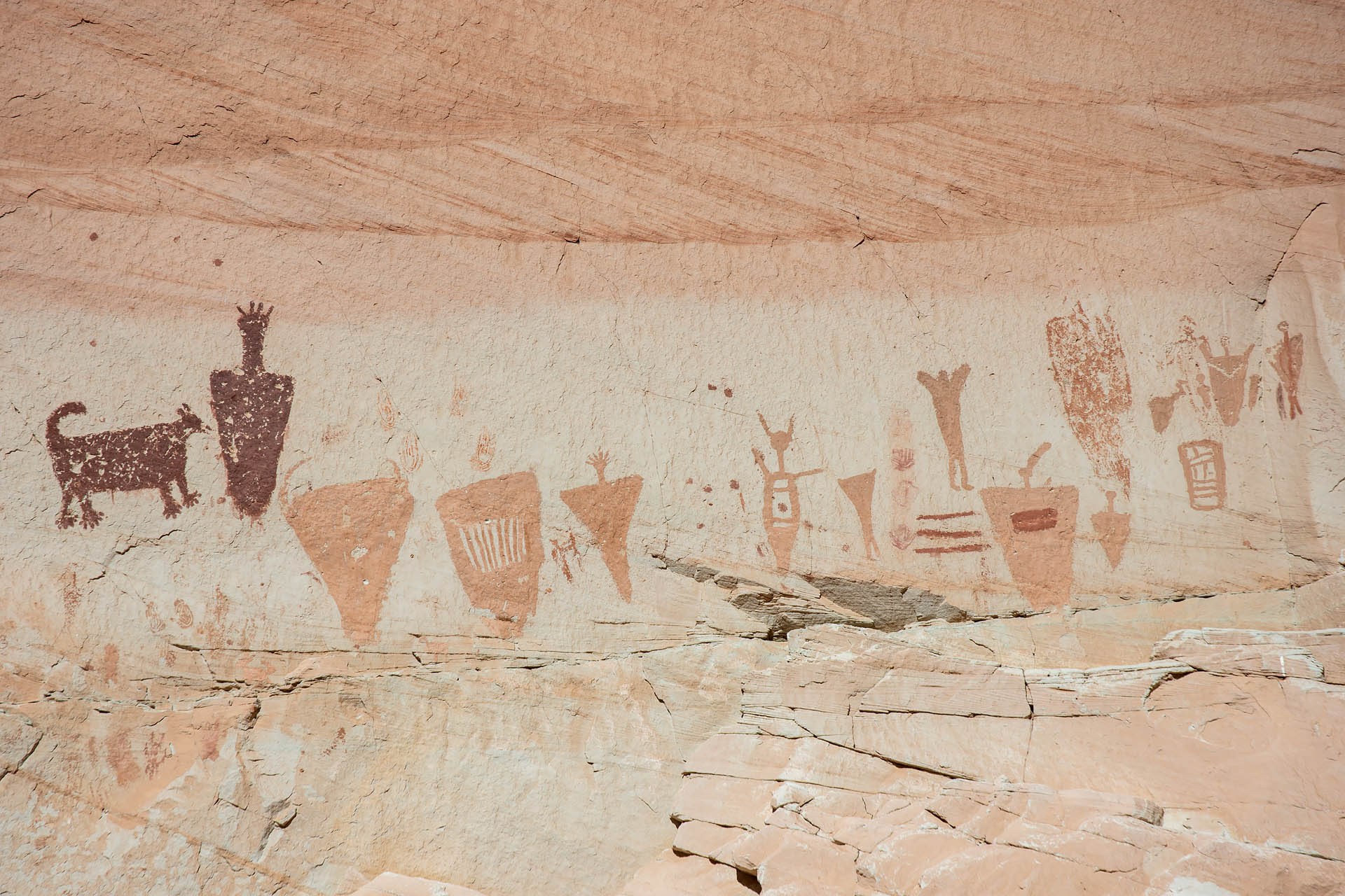
Today, Horseshoe Canyon’s most precious treasures are its galleries of American Indian rock art. The pictographs here are considered some of the most impressive examples of Barrier Canyon style artwork ever discovered. Using pigments such as iron and manganese oxides, the artists adorned the canyon walls with anthropomorphic figures – some life-sized – as well as hunters, animals, and various abstract shapes. The pictographs are splashed across the Navajo Sandstone in four distinct galleries: High Gallery, Horseshoe Shelter, The Alcove, and the Great Gallery.

Easily the most impressive of the bunch, Horseshoe Canyon’s Great Gallery was originally thought to have been created by nomadic hunter-gatherer tribes of the Late Archaic period, sometime between 2000 BCE and 500 CE. However, precisely dating the art has been a huge challenge for historians, due in large part to the destructive nature of sampling the pigments as well as the potential for contamination.
A group from Utah State attempted to overcome these challenges using a novel luminescence technique, and published their findings on the art’s origins in 2014 in PNAS. Rather than analyzing the pigment, they used optically stimulated luminescence (OSL) to date the mineral grains and quartz crystals within the surrounding layers of sedimentary rock. Using this non-destructive technology, the researchers estimated that the pictographs were actually most likely created between 0 and 1100 CE. Though the artwork is still attributed to Late Archaic tribes, their findings suggest the pictographs were completed much more recently than previously believed. Even more interesting, the new timeline suggests the drawings came from a period of cultural overlap between hunter-gatherers and emerging agrarian societies (such as the Fremont) within the canyon.
Getting there
While Canyonlands is just 30 miles southwest of Moab, many trails and camping areas take much longer to reach due to the circuitous routes and unpaved roads. Parts of Island in the Sky (the northernmost and most accessible district) are less than an hour from Moab. However, the Needles District in the southeast is at least a 1.5-hour drive, while The Maze (the most remote, southwest district) will take 4 to 5 hours to reach by car.
The Horseshoe Canyon Unit of the national park is about 2.5 hours from Moab, in an area northwest of The Maze and just west of the Green River. From I-70, follow Highway 24 south for about 25 miles, then take a left onto Lower San Rafael Road. Lower San Rafael Road is a dirt road that traverses the remote San Rafael Desert. While the road is graded and in pretty good shape, be prepared – you will be on it for 31 miles to the trailhead and there is no sign of civilization.
The hike
Stephan’s uncle, a former Yellowstone guide and general wanderer around the southwestern U.S., suggested Horseshoe Canyon to us towards the end of our stay in Utah. It was about a three-hour drive from our house in Monroe, so somewhat of a haul. But with the long, Thanksgiving holiday – and, coincidentally, our last weekend in Utah – on the horizon, we thought we’d give it a shot.
When we started down the thirty-one miles of dirt road through the San Rafael Desert, we weren’t sure what we had gotten into. However, the road turned out to be nicely graded and we never saw another soul out there. Before we’d even reached the trailhead, we were already having a blast. We kicked up dust along sharp corners, took in the views of lonely buttes and seemingly misplaced sand dunes, and just enjoyed the sheer isolation of it all. This was social distancing at its finest right here.


We reached the trailhead after what felt like a semi-epic trek out to the middle of nowhere. Surprisingly, the entrance to Horseshoe Canyon was easily recognizable, with a huge national park sign and small parking area suddenly appearing like a desert mirage. The trail begins at around 5,300 feet in elevation, and descends around 700 feet over 1.5 miles to the floor of the canyon. The descent is entirely down a terrain of rugged sandstone. Small cairns are strewn about to help define the trail, but there is no true path here. About halfway down into the canyon, you pass through a small gate, and the old stock trail suddenly becomes much more obvious.


After clambering down just a short distance toward the canyon, the views out into the gorge quickly opened up. It was barren and bleak, and hard to imagine how many people at one point called this seemingly inhospitable place home.


Upon reaching the bottom of the canyon, the trail abruptly flattened out. Turning to the southwest, the path began to trace the contour of Barrier Creek, a small tributary of the Green River that runs through the canyon. The path soon disintegrated to sand as it continued alongside desiccated creek bed, and we found ourselves surrounded by groves of cottonwood trees and the vertical walls of Navajo Sandstone. It was a completely different world from that above the rim.


As we traversed the canyon, the first set of pictographs we stumbled across were those of High Gallery. A smaller panel of rock art hanging some twenty feet above the trail, this gallery could be easily missed if you aren’t paying attention.


Soon after spotting the High Gallery, we came to another set of drawings in a spot called Horseshoe Shelter. I found this panel especially striking, and particularly enjoyed the four-legged creature on the left-hand side. I’m not sure if it was meant to depict a domestic dog or wild animal, but it just looked so animated and content with its upturned tail and long, intentionally-defined toes. It was like looking at a portrait of an adorable Paleolithic Sanchez (maybe a bit less trim).


Continuing to stroll through the canyon in total solitude, the next site we came to was The Alcove. This huge recess in the canyon wall houses the third gallery of Barrier Canyon style pictographs. The figures here are a bit faded and more difficult to make out, but the chamber itself is pretty cool. It felt like the perfect little secluded retreat.


While we found these first few pictograph panels pretty impressive, Horseshoe Canyon’s real highlight is the Great Gallery, the trail’s final panel of artwork. The images here are astonishingly well-preserved, and the scale is somewhat mind-blowing. The gallery stretches some two hundred feet across the canyon wall with dozens of anthropomorphous forms of varying shapes and sizes. Some are intricately patterned while others are a crude silhouette. One seems to be dancing as it plays a horned instrument, while two others look like a pair of embattled hunters. One group stands markedly distant from all the others, with the central figure topped with an ornate crown that evokes the feeling of royalty. Some of the silhouettes are life-sized, while others are significantly smaller.


In front of the Great Gallery there is a small bench and a couple of logs where you can sit and gaze at the artwork. Beside the bench is a metal box with a pair of binoculars for viewing the sketches in greater detail. With the whole place to ourselves, we pulled out our lunch and imagined the stories the artists were trying to tell. What were the people like? How did society function? What were the most important things to the tribe members at the time?


When we left Monroe in the dark that morning, we questioned whether or not Horseshoe Canyon would be worth the drive. It most definitely was. The pictographs themselves were such a fascinating, impeccably-preserved piece of history, and the canyon’s remoteness and lack of traffic made it that much more special. Altogether, we just really loved this hike. Thanks for the recommendation, Uncle Bruce… it sure was a good one.
Total distance: 8.7 miles
Elevation gain: 824 feet


Know before you go
- Summer temps here can get scorching. There is no guaranteed water source in the canyon, so make sure to carry more than enough water.
- The galleries are sacred to the Native American people, and preserving such artifacts is critical to the survival of their cultural history. If you visit this special site, please respect the artwork and the canyon. Don’t attempt to add your own artwork or carve anything into the stone. Importantly, even the oils from your skin can damage the fragile pigments, so don’t touch anything. Take only photographs, leave only footprints.


