One of our final summit scrambles of the season, we eked this baby out on the 8th of October. It was kind of crazy to think that we still had the opportunity to scramble a summit at this time of year, let alone one approaching 3,000 meters. With an atypically warm and prolonged summer, there hadn’t been a meaningful autumn snowfall here in the Rockies, not even at elevation. Perhaps even more surprising, though, was the day’s high temperature. At 19C (66F), it made it feel even more as if we were still in summer’s midst. Had it not been for the significantly shorter amount of daylight, faded vegetation and barren alpine meadows, it could have been just another day in July.

Molarstone Peak is a 9,450-foot (2,880 m) mountain that rises above Banff’s Mosquito Creek Valley near Molar Pass and the Fish Lakes. The peak sits just north of Molar Mountain and just northeast of towering Mounts Hector and Andromache. Along with The Fang, Molarstone soars directly above North Molar Pass – one of the highest mountain passes in Banff that’s accessible by trail.


Molar Pass and the Fish Lakes are a fairly popular area for backpacking during the summer months. Here, the 32-mile (52 km) Molar Pass Loop wraps around Molar Mountain and through the Pipestone Valley via North and South Molar Passes. If you’re spending some time out here, there are a number of scrambles of varying difficulty including Molarstone, The Fang, Minnow Peak and Molar Mountain. If you’re day hiking, as we were, be prepared for a long day on the trail. The lengthy approach to either mountain pass means you’ll be putting in a minimum distance of about 14 miles (23 km). With October’s quickly diminishing daylight hours, we opted for a 15-mile (24 km) out-and-back up North Molar Pass with an added scramble up Molarstone Peak.
The trail for North Molar Pass begins at the Mosquito Creek Campground along the Icefields Parkway. The trailhead sits just north of Hector Lake and about 17 miles (28 km) north of Lake Louise. There’s a small parking area along the highway where you can park without having to enter the campground. The trail begins on the opposite side of the highway, however, so you will need to carefully cross the road on foot or follow the creek under the highway bridge.
For the first 5 miles (8 km), the path is largely forested as it parallels Mosquito Creek and makes its way around the west and north sides of Noseeum Peak. It’s a pretty moderate grade, gaining just 1,500 feet (460 m) of vertical over the five-mile distance. As you cross the woods, keep an eye out for porcupines. The Fish Lakes area is quite known for its resident porcupines, and we spotted one skittish friend en route to the pass. If you’re camping in the area, be sure to stow all your gear in your tent. The curious and salt-craving critters have been known to nibble on hiking poles and boots.
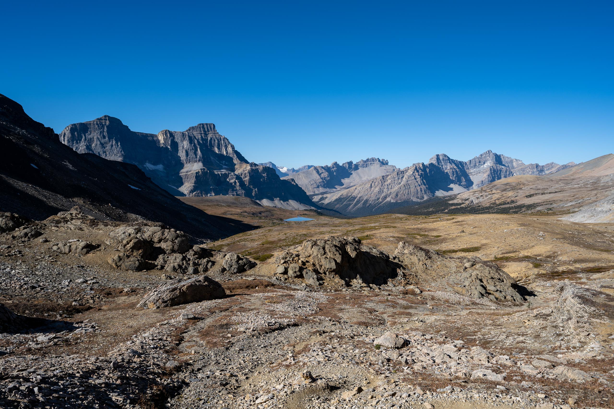
Once the trail finally pops out of the woods, it opens onto the expansive Mosquito Creek Valley. For the next two miles (3 km), the trail winds through the alpine meadows as it makes its way toward the top of North Molar Pass. As you traverse the valley and crest the pass, you’re surrounded by massive summits: neighboring Noseeum and The Fang, as well as Dolomite and Watermelon Peaks to the west.


One we reached the top of North Molar Pass, we could see our target rising above us on the left. From the top of the pass, it’s a mere 0.3 miles (0.5 km) to Molarstone’s summit. That said, there’s about 900 feet (300 meters) of vertical gain over that trifling distance. If those numbers don’t give you a gauge for steepness, check out the little blip in the center of the elevation profile below.
While it’s a technically easy scramble, the scree on Molarstone is wicked loose, making it feel like a battle for every step of positive gain. There also wasn’t much of a discernible path here, as it’s not a very popular peak. Consequently, we ended up slightly hiker’s right of where we wanted to be. As we learned on the descent, had we been just a hundred feet or so further left, we would have had some slightly better footing.


When we reached the summit cairn, we were surprised to find such an empty register. There were just six other signatures from this year and only seven from 2021. It certainly wasn’t the most epic summit we’ve hiked, but we figured it would garner a bit more attention given its proximity to North Molar Pass.


From Molarstone’s crown, we got a decent view of some of Banff’s iconic peaks. Through the hazy southern sun, we could make out a distant Mt. Temple and the peaks of the Lake Louise group. Closer to us, we got a fantastic look at Mt. Hector and the 11,000-footer’s sprawling North Glacier. Next to Hector, we could see Andromache and Noseeum – the former named for the Greek goddess who was Hector’s wife. Andromache was named by the Alpine Club of Canada in 1948 because of her proximity to Hector. However, Hector was not originally named for the god of the same name. The glaciated summit was actually named to honor James Hector, a 19th-century explorer who was part of the Palliser Expedition. The group’s three-year survey of western Canada ultimately helped establish the route for the Canadian Pacific Railway.


Other notable peaks that were visible from the summit included Mosquito Mountain (north), Deluc Peak (northeast), and Molar Mountain. Rising just above the Fish Lakes was Minnow Peak, our objective for another day. We would have loved to go for a double summit day after making the long approach out here, but it wasn’t in the cards with such little daylight. Moreover, with the sun so low in the sky at this time of year, the typically vibrant tarns are never fully illuminated… and I just love a good jewel-toned lake. We don’t mind making a summer return, however. With miles of trail winding through rambling alpine meadows, we imagine the wildflower display out here has got to be pretty spectacular.


It’s hard to believe we were able to bag this 9,450-foot summit the second weekend in October – a pretty extreme elevation to still be accessible that late in the year. Additionally, with such incredible late-season weather, we couldn’t believe we saw no one else on the trail the entire day. We knew it wasn’t the most popular peak, but we figured we’d see at least a couple people heading to the pass. Though the approach to the meadows was lengthy and probably not the most scenic we’ve done here in Banff, the views from the high pass and summit were still worth the effort.


Total distance: 15.1 miles (24.3 km)
Elevation gain: 3,534 feet (1,077 m)


