Tucked away in northeastern Arizona, Petrified Forest National Park sits just three hours east of the Grand Canyon, yet averages ten times fewer visitors per year. It may be more humble in scale and topography, but it’s by no means lacking in fascinating history and landscape. Here you’ll find small trails that wind through colorful badlands, peppered with the agatized remnants of towering Triassic-period trees.
Stephan and I made a day trip thinking it might be interesting – that it was at least worth checking out while we were nearby – and it totally exceeded our expectations. I don’t know if it’s because we’re both hardcore science nerds, but we majorly geeked out over the fossilized forests. If this park hasn’t been on your radar, we think it’s definitely worth a visit. To learn more about the site’s geological history as well as our experience exploring the park, read on!


A primordial forest
Two hundred million years ago, the windswept desert badlands of present-day Arizona were an antipodean universe. Far from the bleak and inhospitable landscape we see today, the region was lush and tropical – a world where early dinosaurs roamed a flourishing river basin blanketed with tropical forests.
As centuries passed, damaged or dying trees from the vast primordial jungle would fall or get washed into the water, quickly becoming buried beneath thick layers of sediment. With no oxygen available, the wood was prevented from decomposing and the trees’ organic compounds were gradually replaced with minerals. Over millions of years, silica from the soil was absorbed into the entombed timber where it slowly crystallized. By the time T. rex ruled the land 135 million years later, the trees had already fossilized into solid quartz.
Sixty million years ago, the uplifting of the Colorado Plateau began to expose the subterranean trees. Still today, relentless weathering and erosion continues to unveil new logs and other ancient remnants from the primordial forest.
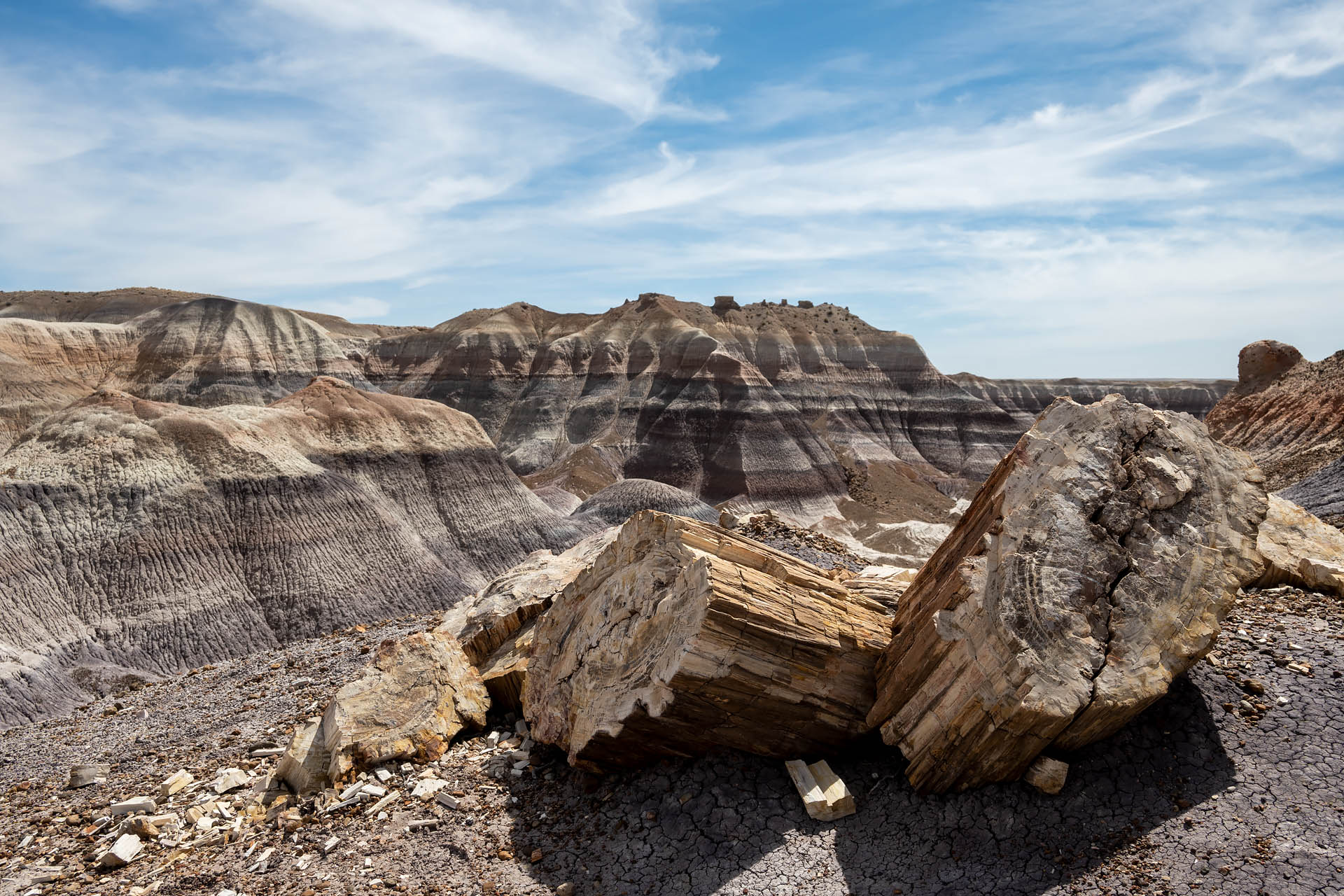
The fossilized trees at Petrified Forest National Park date to the Late Triassic, between 211 and 218 million years ago. Some of the tallest approached 200 feet when alive. Today, the agatized fragments are all that remain of the primeval woodland. And while the trees are now almost entirely solid quartz, many give the illusion that they’d been felled just recently – with visible bark structure and concentric inner rings. It’s such a striking anachronism to see logs peppering an otherwise barren landscape; and as you’re wandering around, it’s kind of wild to imagine you’re standing in the footprint of forests from eras past.


Getting there
Although it’s in the more remote, eastern part of Arizona, Petrified Forest National Park is easily accessible via I-40 (Historic Route 66)… so much so that the interstate actually bisects the northern and southern sections of the park (Painted Desert to the north and Petrified Forest to the south).
If you’re interested in experiencing a little Americana, there are plenty of places you can stop along America’s ‘Mother Road.’ One of the country’s first highways, the 2,448-mile stretch of road was built in the 1920s to connect Chicago with Los Angeles. For decades U.S. Route 66 saw waves of traffic – from the Dust Bowl migrants of the 1930s, to the WWII convoys of the 1940s, to the good old family roadtrippers of the 1950s that kickstarted the cross-country ‘vacation culture.’ While the entirety of the route had been either realigned or replaced by the mid-1980s, portions of the historic road have been since designated a National Scenic Byway.


Historic Blue Forest & Blue Mesa Trails
The Historic Blue Forest Trail was easily our favorite spot in the park. The dirt trail begins right off the main road (Petrified Forest Drive). However, within minutes it feels as if you’ve been propelled into another world. This route can be hiked as a 2.5-mile out-and-back, or combined with the Blue Mesa Trail (a one-mile loop) for a 3.5-mile return. Both trails navigate a particularly scenic section of rolling badlands, so we couldn’t resist checking out both trails.


The Historic Blue Forest trail is one of the few unpaved tracks in the park and, although short in terms of distance, it’s a pretty fantastic little route. The narrow, dirt path winds up and down colorful badlands – hills of ivory and purple and mauve-colored bands that look like they came straight from the pages of a Dr. Seuss book.


As you navigate this alien universe, you spot huge chunks of petrified trees that look as if they were frozen in motion as they tumbled down the hillsides. With no one else around, it did kind of feel like time actually stood still.


After winding through the colorful knolls, the trail makes a quick descent down a dusty mound to join the Blue Mesa Trail – a flat, paved path that snakes along the base of the badlands. This portion of the route didn’t quite live up to the former, but the indigo hills over here were still exceptionally scenic.


Overall, we were seriously blown away by this trail. Neither of us is particularly a desert person; we both much prefer a verdant forest, crystalline lake, or alpine landscape. However this was stunning. Even Sanchez – a veritable mountain dog – had an absolute blast out here. Between being the only ones on the trail, the eye-catching terrain, and the closeup look at the crystallized trees, it was pretty much the perfect outing.


Total distance: 3.5 miles
Elevation gain: 287 feet


Crystal Forest
Crystal Forest is a one-mile, paved loop near the south entrance of the park. While the short, little loops with more foot traffic aren’t usually our favorites, this one was surprisingly cool. The Crystal Forest was originally named for the abundance of sparkling quartz crystals in the petrified wood. Over the years, however, thoughtless visitors have removed some of the crystalized relics. You can still see a number of glittering pieces here if you look carefully as you pass by; but please remember to just look.


This small corner of the park is exceptionally dense with pieces of agatized wood, as it’s the site of an ancient log jam (nearby Jasper Forest is another) The diversity in colors, textures and shapes is kind of remarkable. Stephan and I both thought it was super interesting to examine all the different specimens. Some pieces of wood have flawless, shimmering quartz crystals. Others are a rainbow of hues thanks to trace impurities like iron, manganese and carbon. Some logs have knotted ‘bark’ that could be mistaken for that on a currently-living conifer. And others that haven’t fully agatized look as if they’d been freshly chopped or splintered. Trust us… it’s seriously cool.


If you’re looking for a satisfying place to geek out and lament that you should have been a geologist (just me?), this is a great place to do it.


Giant Logs
Honestly, for as cool as the first two trails were, we could have totally done without this one. Compared to the landscape along the Historic Blue Forest Trail and the fossilized specimens along the Crystal Forest trail, this half-mile loop was completely underwhelming for us.
The trail’s main attraction is ‘Old Faithful,’ a 35-foot log that weighs an impressive 44 tons. Other than its sheer size, there’s not much noteworthy about the tree. If you look at the base, you can actually see where it was repaired with mortar back in the 1960s when lightning struck and cracked the log. It’s bulk is impressive, but (in our opinion) your time could be better spent elsewhere.


Newspaper Rock
A really unique archeological site, Newspaper Rock is named for its impressive collection of ancient pictographs. Spread over a few large rockfaces, the more than 650 symbols and characters were carved into the stone by the ancestral Puebloan people between 650 and 2,000 years ago. The images don’t depict a single story, but rather represent a compendium from many generations of Puebloan people living and farming along the Puerco River.
The site can be found roughly midway between the park’s south and north entrances, between The Teepees and Puerco Pueblo. Here, a short, paved pathway leads to a vista point overlooking the intricately-decorated rockfaces. Because the hillside is unstable, you aren’t allowed to directly access the pictographs; however, the park has installed several spotting scopes that offer a closer look at the images. If you’re interested in photographing the ancient symbols, make sure you bring a lens with decent zoom capabilities (our photos were taken with a 500mm).


Onyx Bridge Trail
Further north, in the Painted Desert section of the park, you’ll find the Onyx Bridge Trail. The Onyx Bridge was once a single piece of petrified wood – a long, Triassic-period conifer – but has since broken into pieces under the stress of its own weight. While you can no longer see a fossilized tree that resembles a wooden bridge across the sand, we picked this route to get a closer look at the kaleidoscopic colors of the Painted Desert.
The trail begins behind the Painted Desert Inn, a historic adobe building that now serves as a museum. Originally constructed from petrified wood in the 1920s, the ‘Stone Tree House’ once accommodated overnight guests as well as hungry lunch-hour visitors. Perched atop a mesa at an elevation of around 6,000 feet, the renovated museum overlooks the Painted Desert below.


From the museum, the trail is easy to follow for the first half mile or so as it descends a series of switchbacks to a large wash. Once you reach the basin floor, however, the trail quickly begins to fade in and out of the landscape. Before you stretches a seemingly endless expanse of flat, arid desert that sits about 400 feet below the rim of the mesa.


The route can be hiked either as an out-and-back or as a stem-and-loop out to the Onyx Bridge. We opted for a clockwise loop, heading slightly left (west) at a largely indiscernible trail split. From here, the trail rises and falls gently over a couple of small hills before crossing over the large Lithodendron Wash. The crude contour of a track then follows a series of narrow washes to the now fragmented ‘bridge.’


The eastern half of the loop – on what was our return trip – largely follows the Lithodendron Wash. This portion of the route is easier to follow as it sticks to the broad, unmistakable dry wash for much of the way back to the trailhead. When you get about a mile or so from the starting point, you can easily spot the Painted Desert Inn balanced at the edge of the mesa, a good visual waypoint if you start doubting your navigation.


If you’re comfortable with route finding, and eager to get a look at the Painted Desert, the landscape you’ll see here is vastly different from the more southern badlands. Rather than patchy hills of purple and blue, the rocks here glow bright red and stretch into the distance as far as you can see.
Know before you go: Bring a GPS map and make sure you’re comfortable with route finding because it’s very easy to lose trail here. Also, make sure your maps are all downloaded ahead of time, because there is no cell reception out here. Some basic trail info published by the NPS can be found here and is a good starting point for research.
Total distance: 5.1 miles
Elevation gain: 562 feet


Painted Forest Scenic Drive
If hiking isn’t your thing or your limited on time, Petrified Forest Road is a 28.5-mile scenic drive that offers a look at the colorful badlands of the Petrified Forest (southern section) and Painted Desert (northern portion of the national park).
The Painted Desert section of the scenic route includes a handful of scenic overlooks on the north side of I-40 including Lacey, Whipple, Nizhoni, Pintado, Chinde, Kachina, Tawa and Tiponi Points. Here, the rolling hillsides radiate with warm shades of vibrant reds, pale pink and burnished ochre.

It’s a striking contrast from the southern end of the park, where cool blue and indigo layers streak the otherwise grayish mounds of The Teepees and Blue Mesa badlands. While the rocks throughout the park are all part of the Chinle Formation, the rust-colored layers are younger, dating to around 205 million years ago. The purplish strata of the Sonsela and Blue Mesa Members are significantly older, having been laid down 216 to 225 million years ago.

The stark differences in color are not due only to age, but also to the environmental conditions when the soils were deposited. While the layers all contain roughly the same amount of iron and manganese, variations in climate affected these minerals. The pinkish-orange layers formed when the climate was drier, and increased oxygen exposure caused the iron within the sediment to rust (oxidize). The bluer strata formed when the water table was higher and less oxygen was available.
To get an appreciation of the full geology of the park, it’s worth driving the entire length of road if you have time. And if you happen to be in the park closer to sunset, east-facing Tiponi Point is pretty spectacular in the end-of-day light.
Know before you go:
- It is illegal to remove any specimen from the national park. If you’re interested in rockhounding, there are places on BLM land in Arizona where it is perfectly legal to hunt for and collect specimens. There are limits on how much petrified wood you can collect, as well as other restrictions regarding collection, so research responsibly before heading out. This Rockhounding in Arizona Guide published by the Bureau of Land Management is a good place to start.
- If you’re interested in rockhounding and want a place to search for petrified wood locally, consider visiting nearby Dobell Ranch. The small ranch has been owned by the same family since the 1930s, and they’ve been working the land and welcoming rockhounds for four generations. We had a great time, which you can read more about here.
- Most of the park’s trails are short, paved routes. We really enjoyed getting off the beaten path at the Historic Blue Forest and Onyx Bridge.
- It’s hot, it’s sunny, and there’s virtually no shade. Summer months can be particularly brutal (90°F on average). Make sure to have plenty of water and sun protection, even if you’re just doing a few miles.
- Unlike a lot of national parks, you won’t find restrooms scattered about at trailheads. The only public restrooms are at the Rainbow Forest Museum (south entrance of the park), Puerco Pueblo, and the Painted Desert Visitor Center (north end of the park). The distance between the museum and visitor center is 26 miles (40 minutes by car), with Puerco Pueblo about midway between the two larger facilities. If you need to use the bathroom, especially before hiking, make sure to plan accordingly.
- Petrified Forest National Park is not open 24/7. It has seasonal operating hours, and the road is gated during off-hours. Be sure to check the website before visiting. When we visited in the spring, the park was open from 8 a.m. to 5 p.m. There are signs at all trailheads reminding visitors of current park hours. If the park closes at 5 p.m., you are expected to be in your vehicle and driving (without stopping) to the nearest exit (either south or north).
- With the previous information in mind, remember to pay careful attention to the time. The national park operates on Mountain Standard Time year-round, as this part of Arizona doesn’t observe daylight savings time. That said, reservation lands in AZ do observe daylight savings time, so the time can change by just driving a few miles across local land boundaries.
- There are a number of trails we didn’t visit. Other short paved/groomed trails to consider include the Tawa Trail, Painted Desert Rim Trail, Agate House and Long Logs. Other options for backcountry hikes can be found here. To hike Devil’s Playground (another backcountry route), you’ll need to get a free permit from one of the park’s two visitor centers.
- If archaeology and ancient cultures are more your jam, consider checking out the short trails to Agate House and Puerco Pueblo. Or maybe pop into one of the park’s museums.
- Petrified Forest is one of the truly dog-friendly national parks. Dogs are allowed on all trails within the park, so long as they are leashed and cleaned up after. Make sure to follow the rules with your pup. There are so few national parks that allow dogs, so please don’t ruin it for everyone. If you visit with your dog, you can also stop by the museum/visitor center to pick up a B.A.R.K. Ranger badge. Sanchez was super proud to show off her shiny insignia.


