Along with Perley Rock, Abbott Ridge was one of our favorite trails in BC’s Glacier National Park. Arguably one of the most beautiful spots in the area, the scenic ridgeline and summit sit just southwest of Rogers Pass in the Selkirk Mountains and offer some seriously stunning views of Mount Sir Donald and the Illecillewaet Glacier.
Like many routes in Glacier, the Abbott Ridge Trail (#18) is a steep, uphill grind. And while a good chunk of the trail is forested, the views atop the ridge are a worthwhile reward for the effort. Additionally, Glacier seems to lack the rabid popularity of nearby Banff and Jasper National Parks, which makes it an even more special place to explore. While Glacier is certainly smaller and less diverse in scenery than its more famous neighbors, it’s by no means short on beauty.

Like most trails in the national park, Abbott Ridge begins at the Illecillewaet Campground. For the first couple miles, the trail climbs fairly steeply through the forest with the occasional switchback to temper the grade. There’s not much to see through here, though the trail does pass by the shores of Marion Lake, a small, wooded pool that you can almost miss if you’re not paying attention.
At around two miles (3 km) from the trailhead, the trail splits into two, forming a modified lollipop route (the two trails ultimately rejoin about a mile before gaining the top of the ridge). Here, a signed junction presents two options: the unambiguously named ‘shorter way’ and ‘longer way.’ The shorter option is steeper and roughly 0.8 miles (1.3 km) one-way; while the latter is pretty moderate and about 1.8 miles (3 km) one-way. If you take the short route, the total distance from the trailhead to the top of the ridge is about 3.8 miles. If you go for the longer trail, it’s about 4.8 miles to gain the ridge.

Route choice is ultimately up to you, although the park recommends the shorter route in the early season, when steep snow slopes can still dominate the longer path. With snow lingering on the longer route until after Labor Day this year (kind of crazy), our first hike to Abbott Ridge was via the short route. Not knowing how much snow remained on the longer, or how stable it was on the heels of a three-week heat wave, we didn’t care to risk it. A steeper, dry ascent was totally fine with us.
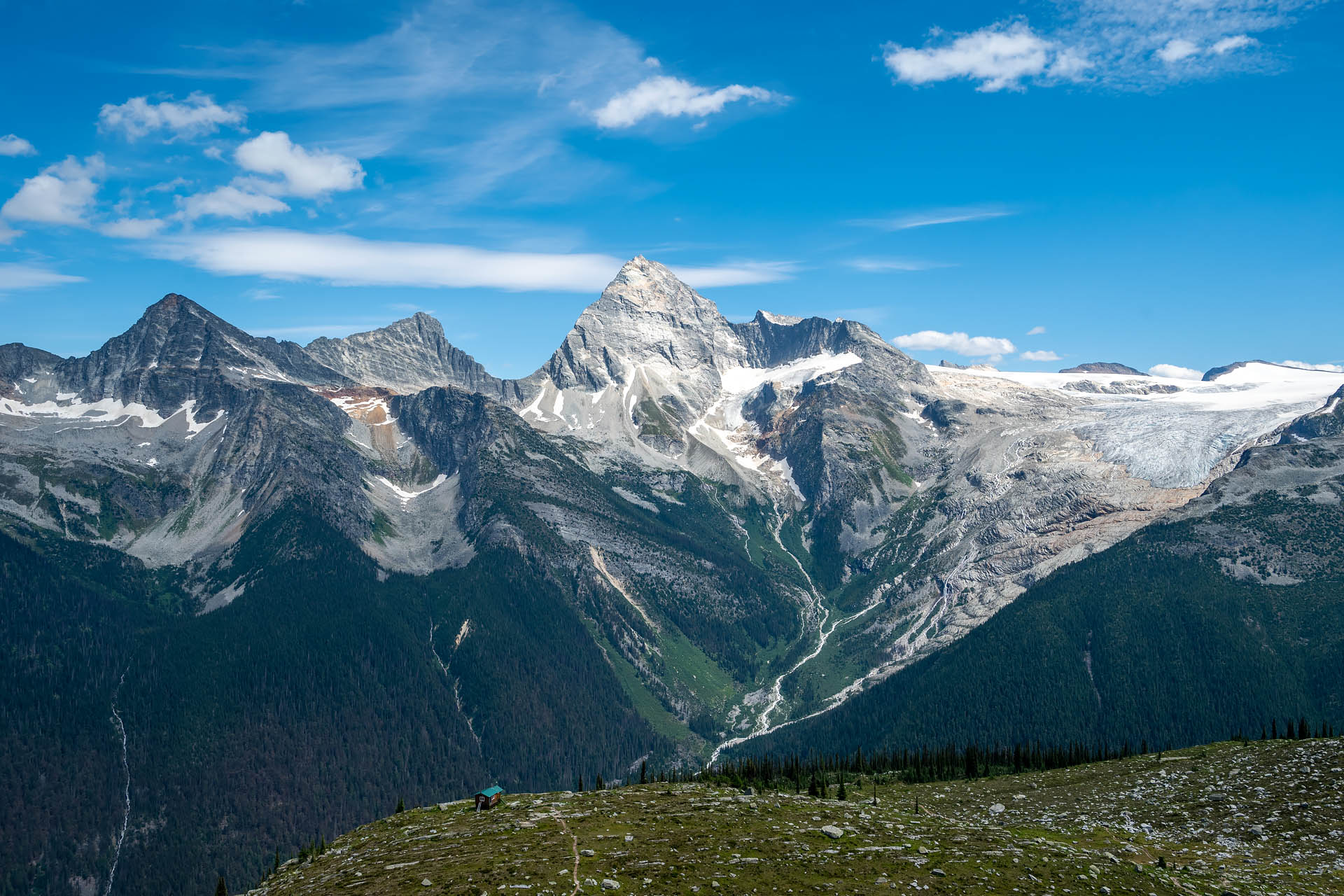
After a reasonably steep climb up the short route, the rocky trail opens up on an alpine meadow just below Abbott Ridge. Here, it meets up with the longer route, where it switchbacks through the open meadow for about another mile. Now above the tree line, the views out to Mount Sir Donald and back toward Rogers Pass really start to open up.


From the meadow to the ridge, it’s about another 700 feet (210 meters) of elevation gain. It’s just enough to offer some seriously gorgeous 360-degree views of the Rogers Pass area, including Eagle and Uto Peaks, Mount Sir Donald, Vaux and Illecillewaet Glaciers, Terminal Peak, Mt. Bonney and Bonney Glacier. Once you gain the ridge, a wooden signpost marks the end of the trail and makes a great little lunch spot.


If you’re interested in a fun scramble, you can traverse the rocky ridgeline to its highpoint, or continue on a bit further to bag Mt. Abbott’s 8,087-foot (2,465 m) summit. If you choose to scramble the narrow ridge, be aware that it is a bit airy in places. The quartzite rock here is nice and solid, but probably not great for those with a fear of heights.


Just before you reach the highpoint of Abbott Ridge, a glacial tarn comes into view beneath the summits of Mount Abbott and Mount Afton. When we hiked the trail in mid-August, the pool was a crystalline turquoise color. When we returned for a second outing in mid-October, the lake had transitioned to a cloudy, greenish hue. If you get the chance, it’s pretty fun to visit the alpine lakes in different seasons to check out the shifting shades of glacial meltwater.


From the highpoint of the ridge, you have to downclimb a short section to reach the saddle before making the final push to the summit of Mt. Abbott. From the saddle, it’s just a quarter mile (0.5 km) and 400 feet (120 m) of vertical to reach the top of the peak. After scrambling the more airy ridgeline, there’s really not much to gaining the summit. The route here is pretty straightforward. While there’s no discernible trail, the rocky crown is marked with a handful of cairns and it’s pretty easy to visualize the line to the top. Just make sure to pay attention to where you’re scrambling here and don’t head too far left. The drop-off on the north side (hiker’s left) of the mountain is massive.


Admittedly, on our first outing to Abbott Ridge, we stopped shy of the summit. We weren’t sure what the scramble was like, and instead of just going as far as we felt comfortable, we just turned around at the saddle. Sometimes an overly conservative scrambler, I was pissed we didn’t at least scope it out. Consequently, we returned about six weeks later to nab the top.
Once we finally made it up there, the views from Mt. Abbott’s crest were pretty stunning – not a lot different from the ridge, but now with a better view of Mt. Swanzy, Swanzy Glacier and Asulkan Glacier. Finding ourselves once again alone atop a gorgeous summit, we spent about forty minutes up here eating lunch and soaking in the views. Sanchez also celebrated her eleventh summit scramble of the season with a bison bully stick. It was hard to believe that it was the middle of October and there wasn’t a speck of snow at 2,500 meters. It was warm enough that it actually felt like an early summer outing, and we were feeling totally grateful to have been lucky enough to enjoy such an extended hiking season.


Whether you stop at the trail’s official endpoint or scramble your way off-trail along the ridge or to the summit, this hike is more than worthy. It was one of our favorite spots in Glacier – and really, all of Canada’s mountain national parks we visited – and one we could see ourselves definitely coming back to.


Total distance: 11.2 miles (18 km)
Elevation gain: 4,186 feet (1,275 m)


Route options
About two miles into the hike, the trail splits at a signed junction for the ‘shorter’ and ‘longer’ routes. As you’d expect, the shorter route is a fair bit steeper. It’s also the preferred route for early season hiking, as steep snow slopes can linger on the long route well into summer. We hiked Abbott Ridge once by going up and down the short route. The second time we hiked the trail, we went up the short and down the long just so we could check out the latter option.


Overall, you don’t really gain any additional views by taking the longer route. You basically just get a few more minutes to look out over Mount Sir Donald. It just comes down to whether you prefer a longer and slightly less steep hike, or shorter trip with a bit more rugged terrain. Distances are as follows:
- Round-trip to the summit via the long route only: 12.2 miles
- Round-trip to the summit as lollipop (short one way, long the other): 11.2 miles
- Round-trip to the summit via the short route only: 10.2 miles
If you aren’t comfortable scrambling, you can stop at the ‘End of Trail’ sign once you gain Abbott Ridge. You still get some beautiful views of Mount Sir Donald and the Illecillewaet Glacier from this point, and it seems to be where most hikers choose to stop. If you’re comfortable with scrambling and some exposure, it’s another 1.2 miles from the trail’s official endpoint to Mt. Abbott’s summit over a narrow and rocky ridge:
- One-way distance from ridge (end of trail marker) to summit: 1.2 miles
- Elevation gain from ridge (end of trail marker) to summit: 810 feet (250 m) including 120 feet (40 m) of elevation loss
If you’re comfortable with class IV scrambling and have gear, you can pair Mt. Abbott with neighboring Mount Afton.


