Tucked away beside Banff National Park’s Egypt Lakes, The Sphinx (Sugarloaf Mountain) is one of the shorter peaks in the area and one that doesn’t seem to get a lot of attention. There’s not a ton of info out there about this minor summit, and I have to wonder how many people bother with this one given that the more prominent Pharaoh Peaks are right next door. But while The Sphinx may be markedly dwarfed by its lofty neighbors, this small summit offers some seriously big views.

If you want to bag The Sphinx as a day hike, it makes for a fairly aggressive outing. While the summit is about 700 feet (200 meters) shorter than the more imposing Great Pharaoh, the roundtrip distance and elevation gain are almost identical – clocking in at just over 20 miles (33 km) with 6,000 feet (1,800 meters) of vertical. That said, if you’re camping at Egypt Lakes, this would be a pretty easy one to nab if you’re comfortable with a little scrambling and route finding.


About ninety percent of the route is the same as that out to Greater Pharaoh. From Sunshine Village, the trail climbs up and over Healy Pass before descending down to Egypt Lakes. From Egypt Lake Campground, the trail then makes a second ascent as it makes its way toward Whistling Pass. When we hiked on the 18th of September, the alpine larches here were just beginning to turn gold – fairly late compared to most seasons.


Rather than continuing around the southwestern side of Greater Pharaoh to either scramble the Pharaoh Peaks or gain Whistling Pass, however, a signed trail branches off to the left that heads toward Scarab Lake. From the fork, it’s a short quarter-mile descent to the lake.


The trail briefly skirts the eastern shore of Scarab Lake, then continues toward Mummy Lake where it eventually passes beside a large boulder field. When you reach the boulder field, you’re about ten miles into the hike. To the left, you can see The Sphinx rising immediately overhead. Instead of following the last quarter mile or so of trail up to Mummy Lake, the route to the top of The Sphinx turns into a bit of a choose-your-own-adventure scramble from here. There’s no discernible trail that leads to the summit – and really nothing in the way of cairns – but it’s easy enough to spot the general line over the boulder field and up to the saddle.


From the saddle between The Sphinx and an unnamed peak to the southwest, it’s a pretty straight shot to the top. The final push to the summit is just a quarter mile, but it’s a fairly steep pitch – gaining around 500 vertical feet (150 vertical meters). Heading hiker’s left (north) from the saddle, there’s occasionally the faint whisper of a track, but not much. There’s a combination of some loose scree and talus, as well as one section of rock ribs where you’ll probably need to use your hands to get up. There’s no exposure here, just a bunch of rubble to get through, all made slightly slower without the luxury of a well-worn path to follow.


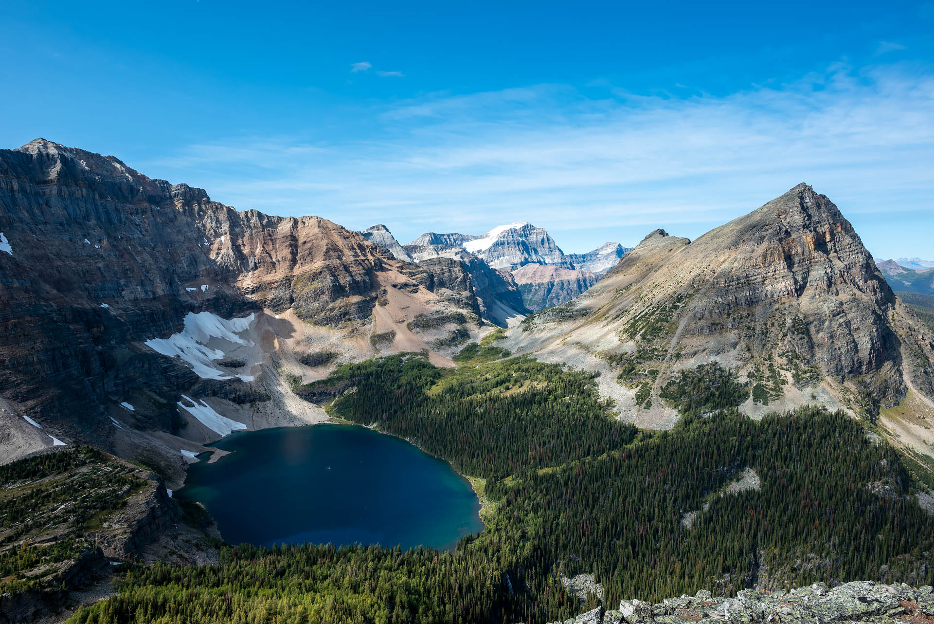
In short order, we found ourselves atop the humble crown of The Sphinx – straddling the Continental Divide and border between BC and Alberta. While it may be the most stunted little knob in the Egypt Lakes area, it’s certainly not short on views. Looking to the north, there’s an absolutely incredible view of Scarab and Egypt Lakes with Greater Pharaoh towering behind. It was cool to look up the western side of the mountain and see the steep gully we’d made our way up just a few weeks prior. Beyond the Pharaoh Peaks, Mount Ball’s massive, ice-capped summit was easily recognizable.


To the east, Mt. Bourgeau, Mt. Brett and Pilot Mountain peeked out of the distance beyond the Pharaoh Creek Valley. On the south side of the summit, the unnamed peak that shares a ridgeline with The Sphinx towered above Talc Lake, with the 9,498-foot (2,895 m) Monarch rising just beyond. Along the northwest side of The Monarch, we could see a swath of matchstick trees, remnants of the 2017 Verdant Creek wildfire. The lightning-sparked fire burned nearly 45,000 acres (18,000 hectares) of spruce forest in Kootenay National Park in what was one of the worst wildfire seasons in British Columbia’s history.


Looking back toward the west, Mummy Lake and Scarab Peak were equally striking. While we didn’t get quite the panoramic look at all three lakes like we did atop Greater Pharaoh, the lighting for photos was much better from The Sphinx. Instead of shooting due south into harsh sunlight, the north- and west-facing views here afforded much better color on the vibrant, jewel-toned pools. It was just beautiful.


While we saw only about half a dozen people when we hiked Greater Pharaoh, Stephan and I saw absolutely no one on the trail to Scarab Lake or on top of The Sphinx. Given it’s diminutive size – 8,220 feet (2,500 m) versus 8,901-foot (2,713 m) Greater Pharaoh – we speculated that this may be a comparatively overlooked little peak.
Although The Sphinx is quite a bit shorter than Greater Pharaoh, the vertical gain from the trailhead at Sunshine Village is exactly the same due to the descent to Scarab Lake and then down to the gully on the southwest side of The Sphinx. We forgot to account for this loss when we first checked out the route. Consequently, our presumed 5,000-foot (1,520 m) gain day turned out to be 6,000 feet (1,830 m) – always a fun surprise when you get back to the car and check your Garmin, bewildered at why your time wasn’t significantly better.
Although the majority of this twenty-mile slog was an echo of our Greater Pharaoh outing just a few weeks prior, the trip out to The Sphinx instantly earned a spot on our list of favorite Banff hikes. The scenery in this part of the park is just so spectacular and, because of the distance required to get out here, seems to be meaningfully less trafficked. Although it requires quite a bit of stamina for a day hike, Stephan and I both agreed we’d come back again in a second. Hopefully someday in the not-too-distant future, we’ll make it back when the larches are at their golden peak.

Total distance: 20.5 miles (33 km)
Elevation gain: 5,992 feet (1,830 m)


