For the first time in the six weeks we’ve been in Leavenworth, we finally picked out a hike that was right here in town. I don’t know why it took me so long to stumble across this trail, seeing as hike research has pretty much become my new full-time job, but it somehow managed to evade my dozens of searches. You know what they say, though, good things come to those who wait… or those with obsessive persistence. It was the first weekend in May, the weather was absolutely stunning, and we weren’t spending 2 hours in the car driving to a trailhead. We were pumped.

Getting there
The Canyon Crest and Rat Creek Ridge Trailhead is about 15 minutes (4 miles) south of downtown Leavenworth, right off Mountain Home Road. It’s a residential, dirt road with just a small parking area, so if you decide to venture up here, be respectful of traffic flow as well as others’ property. Additionally, be sure to stay on the designated Mountain Home Ridge trail system (it’s well marked and signed at the trailhead) as the surrounding area is private property.
Route options
For a short hike, the Canyon Crest-Rat Creek Ridge Loop is about 3.5 miles roundtrip. If you want to add on the 1.8-mile spur (600’ of elevation gain) to Boundary Butte, the total trip will be just over 7 miles.
There’s also a 0.75-mile spur on the Ridge Ride Trail1, running in the opposite direction as the main loop. This can be used to add an additional 1.5 miles roundtrip onto either the shorter, standard loop (now 5 miles total), or the route up to Boundary Butte (now ~8.5 miles).

The hike
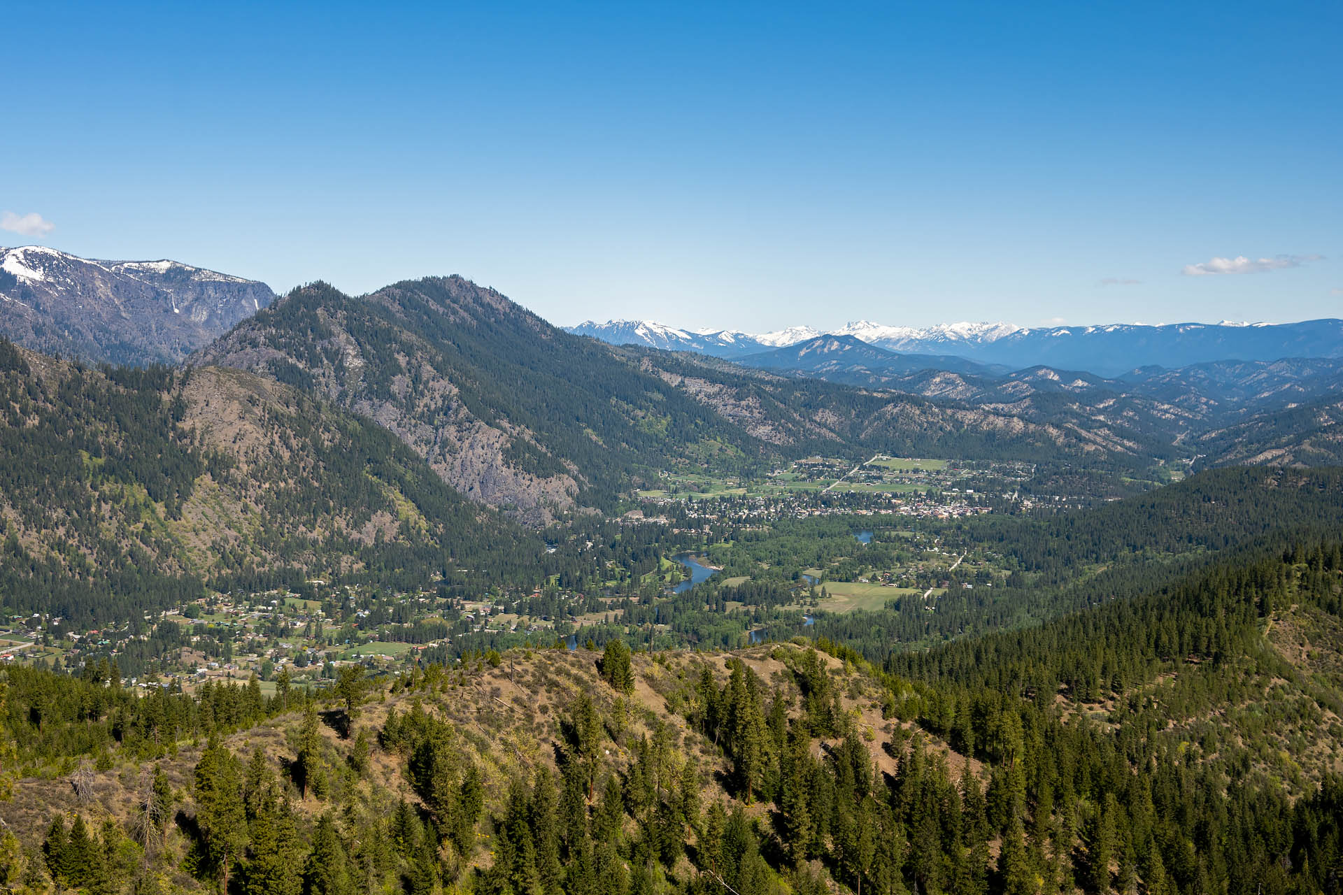
With some nice morning light illuminating the town of Leavenworth, we decided to hike the first part of the loop counterclockwise along the Rat Creek Ridge Trail. Based on the map and suggestions of other hikers, this half of the loop offered the best views. From the parking area, the trail begins at a gated-off, decommissioned service road. After about 0.4 miles, a large informational sign with detailed map marks the official start of the trail system. Keeping right from the trailhead sign, we walked for another 0.4 miles before coming to the split for the loop (right: Rat Creek Ridge, left: Canyon Crest). Bearing right, we followed the Rat Creek Ridge Trail along a scenic high ridge overlooking Leavenworth. As others suggested, this is arguably the most scenic section of trail, with sweeping views of the Leavenworth Valley and surrounding peaks.


After less than a mile, the trail starts to turn away from the open ridgeline, heading back toward the trailhead via the Canyon Crest half of the loop. Wanting to continue the hike, we chose to continue straight and head up to Boundary Butte. The hike up to Boundary Butte’s summit (~3,300’) is a nice addition to the route, albeit primarily on a forest service road (NF 7300-500). Continuing straight from the Canyon Crest turnoff, the trail continues a gradual climb for about 0.75 miles until it reaches a T-intersection with the service road. From here, take a left and follow the road for just over a mile to the top of the butte. The views to the west and north are quite lovely. While the views overlooking Leavenworth don’t change much from the lower ridgeline, you do get a better glimpse of Cashmere Mountain rising in the distance.


After Sanchez enjoy a handful of summit snacks, we descended Boundary Butte and headed back toward the trailhead via the Canyon Crest Trail – the back half of the main loop. There are no real views from this side of the trail, so if that’s your primary objective, you may want to just do an out-and-back along the Rat Creek half of the loop.


Once we arrived back at the main trailhead, we decided to continue on the spur trail to the left. It was marked as part of the official trail system on the map1, so we thought we’d check it out. It was just too gorgeous a day to not be on the trail. While were able to walk only about three-quarters of a mile before the trail terminated at a large ‘private property’ sign, it was still a pretty little addition to our outing. No one was on this section of trail, and there was a nice view looking back to Boundary Butte’s stunted summit. Additionally, the balsamroot through here was just spectacular, with some of the largest and showiest blooms we’ve seen all season.


Heading back to the car, we were both really pleased that we’d found this trail. It was really peaceful when we started out in the morning (trail traffic did pick up a bit after lunch), and was surprisingly scenic for a short little trail. If you’re anxious to get out for an early season hike around Leavenworth, Mountain Home Ridge is a great option.
Total distance: 8.6 miles
Elevation gain: 1,381 feet


1Note: The large sign at the trailhead shows a route running in the opposite direction of the main trail system, culminating at a marked overlook before terminating at a private property line. We’d studied some maps online before heading out, and it looked like this section of trail was the Ridge Ride Trail. While it looks like the trail stretches for a couple miles to Peshastin Lookout on some (presumably older) maps, it does in fact terminate at private property after about three-quarters of a mile. The current terminus is well marked with a large barricade, but if you want to tack on an extra mile and half to your hike, the short, publicly-accessible portion is really lovely.


