Back in July, we made our first trip to the Bugaboos. After just one visit, we were smitten. With sheer granite spires erupting from a vast sea of ice, it’s a landscape unlike any other you’ll find in the surrounding area. This quiet corner of the Purcell Mountains is remote and takes much more effort to get to than many of the neighboring provincial and national parks. As such, it’s much easier to escape the crowds, especially if you’re just hiking.
While the wilderness area boasts a number of coveted technical climbing routes, there are just two hiking trails in this small provincial park: one that leads to Applebee Dome via the Conrad Kain Trailhead, and one to Cobalt Lake. A 26-foot (8-meter) ladder up a granite slab prevented Sanchez from joining us on the first route up to Applebee, so she was stoked when we told her she’d able to come along to check out the remaining trail up to Cobalt Lake.

Getting started
The trailhead for Cobalt Lake is just a kilometer or so before the Conrad Kain Trailhead. Consequently, getting there requires the same 50-kilometer (30-mile) drive up the unpaved access road. There’s no real parking area here, so you’ll need to take care to pull off the shoulder properly to allow traffic to pass. Just like the Conrad Kain Trailhead, you’ll find a small supply of chicken wire and stakes lying around the bushes to safeguard your vehicle from the mischievous porcupines, particularly important if you’re overnighting.
The roundtrip trek to Cobalt Lake clocks in at around 11 miles (17 km). While the majority of the trail is easy to follow, there is about a half mile where you’ll need to do some route finding. Make sure you’ve got a GPS map downloaded offline (you definitely won’t have any hint of service here) and are comfortable navigating with no real trail markers. The Golden Hikes website has a map outlining the easiest route to the lake, so make sure your track roughly lines up with this one. We saw one pair of hikers clambering up a super steep ridge from the meadow rather than using the much easier and more obvious path through the gully. We couldn’t figure out if they’d made a mistake navigating or if they were just looking to unnecessarily destroy their knees on some vertical terrain.

The route
For the first three miles (5 km) or so, the trail switchbacks steeply through the forest – gaining about 1,000 vertical feet per mile. There’s not a lot to see through here, though there is an optional side trip to Walker Lake. The junction for Walker Lake is signed and just under two miles (3 km) from the trailhead. It’s only about 500 meters (0.3 miles) one-way to the lake, but the trail does gain a couple hundred additional meters along the way. Wanting to have more time at Cobalt, we skipped the detour.
About three miles (5 km) into the hike, the trail finally pops out atop Cobalt Ridge. From here, the trail to Cobalt Lake heads hiker’s right. If you follow the trail to the left, it continues to follow the ridge crest and offers the opportunity to do a bit of scrambling. If you want to take a quick detour in this direction, you can get a beautiful look out to Bugaboo Glacier and Hound’s Tooth after just a couple hundred meters.


Continuing toward Cobalt Lake, the trail reaches a faint junction after just a couple hundred meters (~0.1 miles). If you head slightly right, the path traverses the ridge for about a half mile until it reaches a cairn marking the highpoint. Alternatively, if you bear slightly left, you can begin immediately crossing the alpine meadow without continuing up along the ridge. Whichever you choose, the views are fantastic.


We opted for the first choice, following the slightly higher ridgeline to take in the views of Cobalt Lake and the surrounding spires before dropping into the meadow. After reaching the highpoint, the trail dips down (hiker’s left) toward the bench. This is the point where you’ll need to do a bit of route finding. There aren’t really any cairns through here – at least, none that we spotted – so a GPS map will prove invaluable. If you look ahead, you can roughly gauge the route from the contour of the terrain. The line you want to follow heads more or less northwest where it eventually descends down from the meadow via an obvious gully.

Once you find the gully and begin descending toward the lake, an easily discernible path suddenly reappears. The well-worn trail continues for the remaining mile (1.6 km) to the lake. As you make your way there, the path meanders through some gorgeous wildflower meadows that were awash with some of the most vibrant paintbrush blooms we’ve ever seen.


The trail then crosses Cobalt Creek and heads hikers’ left of a small waterfall, climbing one last hill to the eastern shore of the lake. We were kind of taken with how pretty it was down here, and even more so with the total lack of foot traffic.


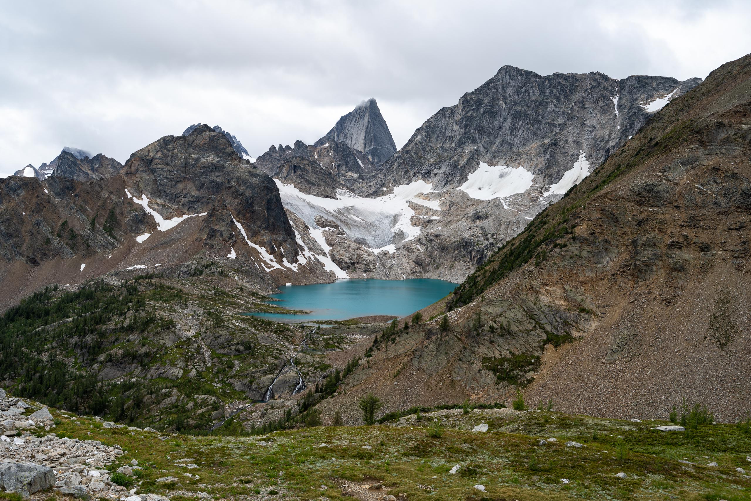
Aptly named, the stunningly azure ripples of Cobalt Lake are tucked away in a cirque beneath Brenta and Cobalt Lake Spires. While the views from the high ridge were pretty breathtaking, the scenery around the lake was equally striking. When the sun popped out, the lake was an almost blinding shade of turquoise, a stark contrast from the steely spires that encircled the tarn. Unfortunately, we had some stubborn cloud cover to contend with once we reached the lake, but it was a beautiful little spot nonetheless.


For Stephan, this hike was an instant favorite. Even having explored a few hundred miles of trails around Banff, Jasper and Glacier National Parks, something about this one just called to him. Consequently, I immediately promised we’d try to make a return trip later in the season. With any luck, we’ll be able to see some snow-covered spires before we head back east in November.


While Stephan and I were partial to the views from the high ridge – as well as the dazzling late-season wildflower blooms (we hiked August 28th) – Sanchez was a huge fan of the many marmots whistling and scurrying around the alpine meadow. By the time we were midway through our return trip, she was just about trembling with excitement. Like Stephan, I think this outing may have been an all-time favorite for her.


If you’re looking for a trail with very little foot traffic and awesome views – and don’t mind the remote drive and extra route finding – Cobalt Lake is a pretty great place to explore.
Total distance: 10.7 miles (17.2 km)
Elevation gain: 4,600 feet (1,400 m)


Know before you go
- Compared to the accessibility of the nearby national parks, getting to the Bugaboos takes a bit more effort. The isolated spot is about 70 miles (115 km) south of Golden, and the park’s two trailheads (Conrad Kain Hut and Cobalt Lake) lay fifty kilometers up a dirt road. Make sure you’re properly prepared, because it’s much more off the beaten path and facilities and cell phone reception are basically non-existent.
- If you’re enjoying the views from the ridge crest, you can continue to hike along the spine rather than dropping down to visit the lake. Cobalt Ridge parallels the eastern side of Vowell Creek and looks like it stretches quite a ways into the distance. A trip report on Golden Hikes suggests there may be the potential to wander for some twelve kilometers along the ridge (though this was just someone’s speculation having looked at a topo map). While we can’t confirm the actual distance you can explore without getting into any major scrambling or other difficulties, it does look like a somewhat worn path stretches for a good bit further into the distance. Perhaps an adventure for another day.


