Established in 1910, northwest Montana’s Glacier National Park is home to some of the country’s most pristine wilderness. Encompassing the jagged peaks of the Lewis and Livingston ranges and home to an abundance of native plant and animal species, the park was designated a UNESCO World Heritage Site in 1995.


Glacier’s rugged landscape was shaped by the movement of vast ice sheets that covered the region during the Pleistocene Ice Age, between 12,000 and 2.5 million years ago. The glaciers that remain today, however, are much younger. They likely formed around 6,000 to 8,000 years ago and grew in size during the Little Ice Age (400–500 years ago).
In 1910, when the national park was established, about 100 glaciers peppered the landscape. That number is much lower today, with only about two dozen meeting the size criteria to be considered active glaciers. Regrettably, those glaciers that do remain have retreated rapidly within the last century, driven largely by human-induced effects on the environment. And while glaciers may be the park’s namesake, they make up just a tiny fraction of the national park. Glacier has so much more to offer outdoor lovers – from shockingly turquoise glacial lakes to dramatic summits and a host of wildlife.


We visited Glacier regularly during our three-month stay in Whitefish, and we’ve included some of our excursions and tips to both inspire your exploration and assist with planning. While the easternmost portions of the park were closed during our visit due to the COVID-19 pandemic, we were able to explore the western and northern areas. Although we were disappointed to miss a few of our top hikes, we now have even more reason to return!
Going-to-the-Sun Road
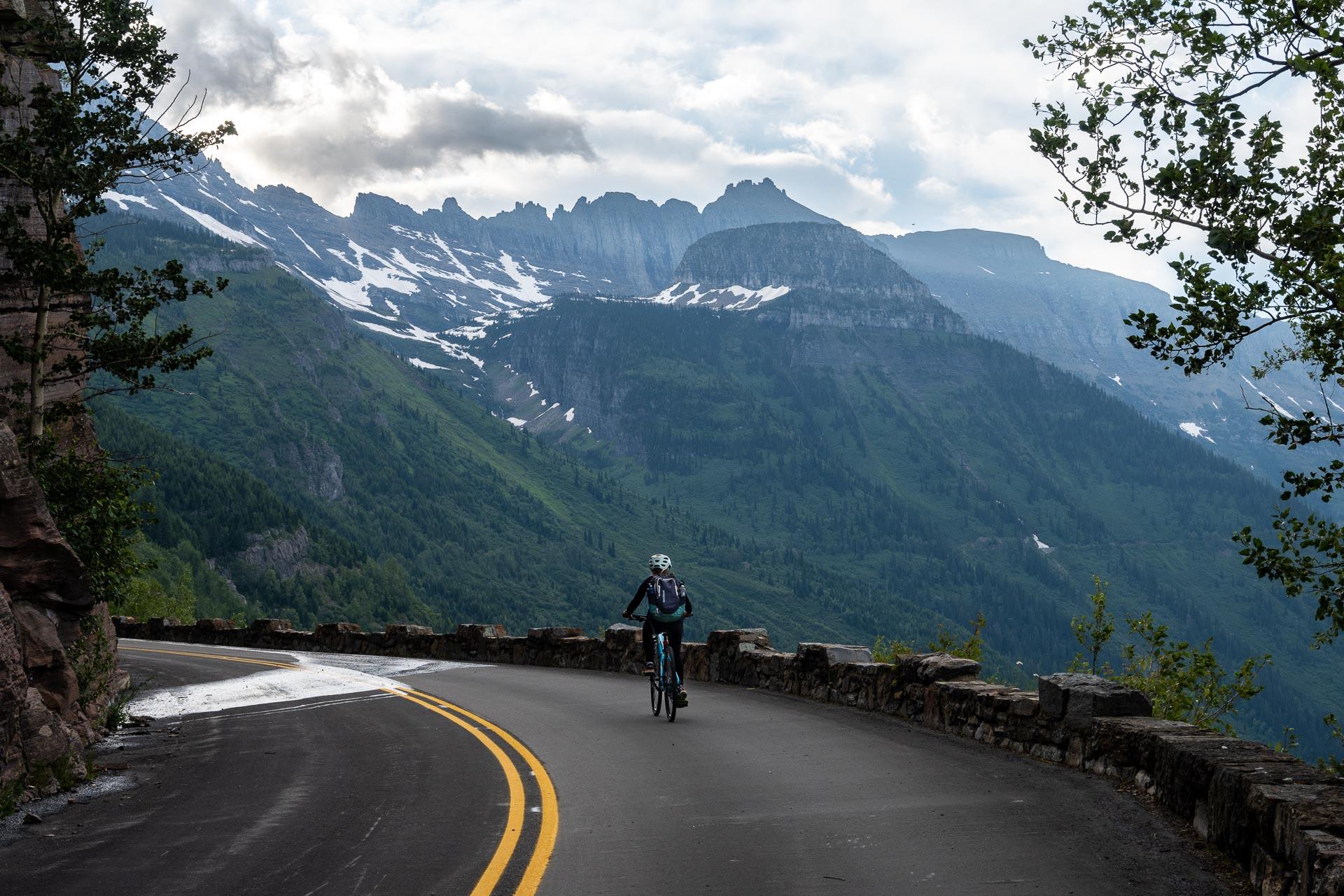
One of Glacier National Park’s biggest draws is the Going-to-the-Sun Road. Completed in 1933, it was one of the National Park Service’s first major efforts to cater to vehicle tourism and increase accessibility within the park’s boundary. Named after neighboring Going-to-the-Sun Mountain, the road stretches roughly 50 miles between Lake McDonald on the west and Saint Mary Lake on the east. The road’s biggest attraction is Logan Pass – the road’s highpoint at 6,646 feet. Situated on the Continental Divide, Logan Pass offers a variety of scenic overlooks and also serves as the starting point for the popular Hidden Lake and Highline Trails.


The alpine portion of Glacier’s Going-to-the-Sun Road is open seasonally – typically opening to motor vehicles in late June or early July, and closing again by mid-October. The road’s opening is dictated by crews’ ability to clear the massive accumulation of seasonal snow. Each year, the biggest challenge for plow crews is the Big Drift, an area just east of Logan Pass that is regularly buried under some 80 feet of snow. Similarly, the road’s fall closure is also weather dependent, sometimes occurring as early as mid-September. Lower elevation portions of the road, however, remain open year-round, providing access to some locations.
Each spring before the road opens to vehicular traffic, the park allows cyclists to pedal from the western side of the park to Logan Pass. From the preferred starting point at Avalanche Creek, about 15 miles from the west entrance, the journey is 32 miles roundtrip with about 3,500 vertical feet of gain. If you enjoy cycling and ever have the opportunity, this is such a special way to enjoy this part of the park. If you’re interested, read about our experience pedaling the pass.


Hiking around Glacier
Glacier National Park offers outdoor enthusiasts 734 miles of scenic hiking trails, from shorter day hikes to longer, multi-day excursions. With trails leading to jewel-toned lakes, tumbling waterfalls, evergreen forests, alpine meadows, frozen glaciers, high mountain passes, and craggy summits, there’s certainly something to captivate any outdoor enthusiast.
Glacier’s trails crisscross more than one million acres of land – from North Fork and Goat Haunt in the north, to the Lake McDonald Valley in the west, and to Many Glacier, St. Mary, and Two Medicine in the east.

Because our stay in the area coincided with the COVID-19 pandemic, a number of trails remained closed for the season. The eastern side of the national park borders the Blackfeet Indian Reservation, and with COVID cases surging, officials made the prudent decision to keep visitors away from the tribal land. Because of this, our hiking was limited to the western and central areas of the park. While we were unable to hike several of our top trails in the Many Glacier and Two Medicine areas this summer, we fully intend to make a return visit. Here are the handful of hikes we did complete during our time in Glacier:
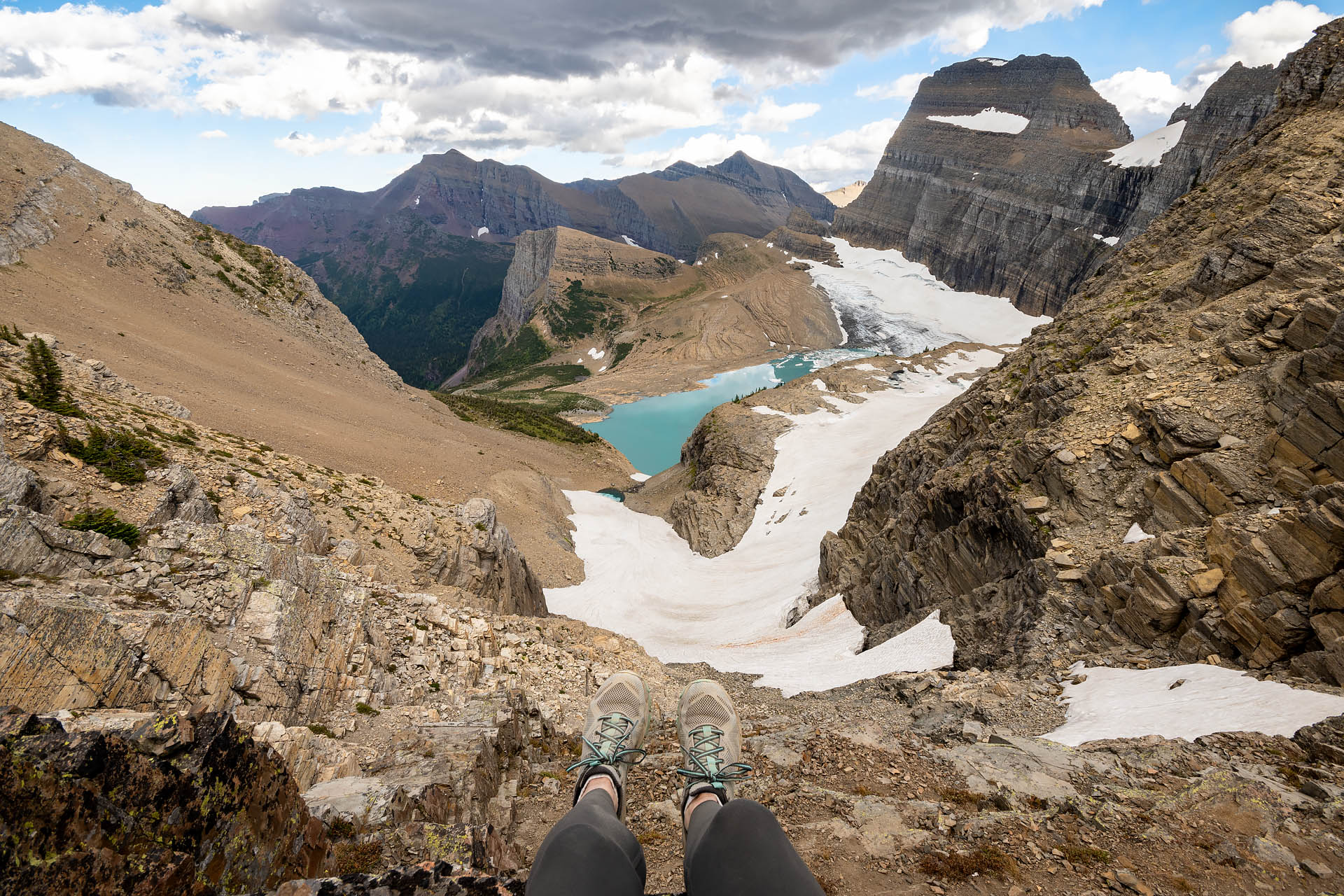
Sperry Chalet / Sperry Glacier
Bowman & Kintla Lakes
Located in Glacier’s remote, northwest corner lie Bowman and Kintla Lakes. Getting to the two lakes is a bit more challenging than visiting the easily accessible Lake McDonald and Saint Mary Lake, but the turquoise waters and majestic mountain views are worth the effort. Bowman’s turquoise waters are surrounded by the craggy crowns of Mt. Peabody, Mt. Carter, and Rainbow Peak, while the serrated summit of Long Knife Peak and the pointed King Edward Peak tower above Kintla Lake.
Bowman Lake is about 30 miles north of Lake McDonald via the North Fork and Inside North Fork Roads. The drive is along rough, dirt roads, so take care when traveling to the lake. Kintla Lake is about 20 miles further north, not far from the Canadian border, and this section of road is quite a bit worse than that leading to Bowman. Before you travel here, make sure to read the regulations and check the road status. There are restrictions on vehicle length and tow-behind trailers, and the road is only open seasonally (with some portions even remaining closed during the summer months for repair).
I spent our last day in Montana on a little North Fork adventure. Stephan was working, and I was feeling a little sad to be leaving, so I thought one last visit to Glacier was needed. My solo excursion began at Bowman Lake. I arrived mid-morning to some absolutely stunning scenery. Moreover, with the campground having closed on Labor Day, it was exceptionally peaceful. I walked part of the trail around the lake, then just sat on the shore soaking up the warm sunshine. I even had an impromptu lunch date on the beach – a sweet little frog who gobbled up flies from the comfort of his warm rock while I ate my PB&J.


With plenty of time left in the day, I decided to make the 20-mile journey up to Kintla Lake. I figured if I was that close, I couldn’t leave without checking it out. The road to Kintla turned out to be more of an undertaking than going over to Bowman. It took about an hour to make the 20-mile trip, with the last several miles of road north of Ford Creek being exceptionally exciting. While we’d driven over a number of nasty national forest service roads throughout the Flathead, this was my first behind the wheel. I’m not sure if Stephan would have been impressed or appalled with my off-road skills, but I consider the journey a rousing success – I was not stranded in the middle of nowhere with a disabled vehicle and no cell service.


Kintla Lake was comparable to Bowman in beauty. Imposing peaks soared above the rippling, turquoise lake, and only a few other people dotted the shoreline (like Bowman, Kintla’s campground also closes after the Labor Day holiday). If you’ve got the time and a reliable vehicle, both Bowman and Kintla are gorgeous areas. And while I didn’t stick around long enough for sunset, I’d imagine that the late-day light would be just stunning on the peaks (standing on the shore and looking at the mountains, you’re facing almost due east).
If you’re interested visiting either of the lakes, both offer primitive (seasonal) campsites as well as a number of hiking trails. Additionally, both lakes can be used for non-motorized watersports:
Bowman Lake Campground
https://www.nps.gov/applications/glac/cgstatus/camping_detail.cfm?cg=Bowman%20Lake
Kintla Lake Campground
https://www.nps.gov/applications/glac/cgstatus/camping_detail.cfm?cg=Kintla%20Lake
North Fork Hiking Trails
https://www.nps.gov/glac/planyourvisit/hikingnorthfork.htm
Know before you go
- Some roads in the national park have vehicle restrictions regarding length, height, and tow-behind trailers. Such roads include the rough and lightly trafficked Inside North Fork as well as the popular Going-to-the-Sun Road. Before traveling through Glacier, be sure to research all regulations: https://www.nps.gov/glac/planyourvisit/gtsrinfo.htm.
- Dogs are not allowed on trails or in the backcountry of the national park. If you intend to do some hiking, unfortunately your furry friend is going to have to stay home. For more information on Glacier’s pet policy, check out: https://www.nps.gov/glac/planyourvisit/pets.htm.
- Weather conditions affect some of the roads through Glacier National Park. The alpine section of the Going-to-the-Sun Road as well as the Inside North Fork close during the winter months. Additionally, changing weather conditions can temporarily close sections of roads. The park is very diligent about reporting current road statuses and conditions, which can be found here: https://www.nps.gov/applications/glac/roadstatus/roadstatus.cfm.
- Similar to roadways, it is common for some of Glacier’s trails to close temporarily for visitor protection, due to factors such as inclement weather or bear frequenting. The popular trail to Hidden Lake is frequently closed due to bear frequenting, while the highly trafficked Highline Trail can close due to snow/ice accumulation. Always check the trail status before setting out on a hike: https://www.nps.gov/glac/planyourvisit/trailstatusreports.htm.
This page is particularly useful for checking area closures and postings/warnings: https://www.nps.gov/applications/glac/infobull/closures.cfm.
- A wonderful amenity offered by the national park is the fare-free shuttle along the Going-to-the-Sun Road. This is especially helpful for hikers intending to do longer point-to-point day hikes that start and end along the Sun Road. For a map and list of shuttle stops and timetables, refer to this page: https://www.nps.gov/glac/planyourvisit/shuttlestops.htm.
- While some campsites are first-come first-served (Bowman & Kintla Lakes included), a few require advance reservations. Additionally, a permit is required for any backcountry camping: https://www.nps.gov/glac/planyourvisit/permitsandreservations.htm.
- If you’re in the North Fork area and looking for an awesome bakery in a historic building, check out the Polebridge Mercantile. They’re locally famous for their huckleberry bear claw, and have a pretty impressive selection of other baked goods as well. One of Stephan’s favorites: the huckleberry brownie.


